
![]() Disappeared when updating Weather4D Pro to Weather4D Routing (¹), Iridium satellite passage prediction returns as a small stand-alone application : iWatchSat.
Disappeared when updating Weather4D Pro to Weather4D Routing (¹), Iridium satellite passage prediction returns as a small stand-alone application : iWatchSat.
Presented with the same interface as Weather4D apps, it optimizes the connection for downloading GRIB files.
At the launch, a tap on the central clock in the upper banner to return to the current time, then tap on the "Next" button displays the time at which the next satellite pass over to you for at least 5 minutes to more than 30° above the horizon (default mode). Something to be assured of maximum signal. This passage is shown in the world map by a luminous circle.

The settings button allows you to change these two values. Indeed, once offshore, without any obstruction, we can lower the elevation at 20° and increase time de facto up to 5mn30s. This will download a file 50 up to 55 KB with the same satellite (²).
Currently, a satellite rising on the horizon takes approximately 7 minutes to disappear on the opposite horizon. 11 satellites follow each polar orbit, and orbits are shifted slowly relative to the rotation of the earth. Thus, when a satellite is properly up above you, you are virtually guaranteed that many others will follow. It is therefore possible to download biger files, by relaunching the connection each new satellite pass, until completely obtaining file. This is particularly optimized with Weather4D in direct connection with an Iridium GO!®. The fact remains that the data throughput is very slow, and one can hardly exceed 10 KB per minute download, sometimes less with connection resume. However, once offshore, it is rarely pressed for time !
The database used is the ephemeris of the current Iridium constellation. It will be replaced by the new Iridium NEXT constellation (³) as soon as it has been declared operational by Iridium Communications Inc..
–––
(¹) Weather4D makes its (r)evolution
(²) The file size displayed in Weather4D is a raw size . A compression rate is applied when downloading, of the order of 15 up to 20% via SailDocs, 25 up to 35% live on Weather4D servers with Iridium GO!®. It is usually possible to create requests displaying a size 60-70 KB for the passage of a single satellite via SailDocs, but much more in direct download Weather4D.
(³) Iridium NEXT maintains its schedule [Update-3]
–––
Having an older model phone satellite this application I used to get the grib files on computer via messaging Skyfilemail ( fast ) or OnSatMail ( Slower)
Thank you for delivery
Thank you for this article. I do not still have the utility, but I wondered about the volume of a file with a single satellite (I understand that the same query can continue satellite satellite) : Article perfect answer there.
So I wanted to watch the area it covers GFS (by downloading only the "wind" info, gusts »).
65KB, it covers an area of about 180 nm by 70 nm (I really looked quickly-made).
If we ask to also receive "precipitation and pressure and cape", I think I saw that the area is reduced to 70 nm by 40NM for the same file size.
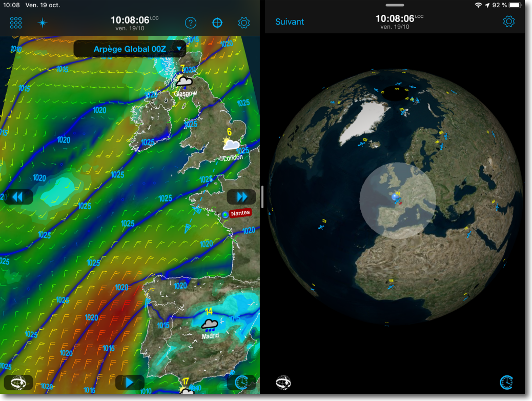
I wanted to compare with Arpège Global (I say perhaps a mistake error but it seems to have read only by request via GRIB W4D and Iridium Go, W4D the GFS servers provide only), and I was surprised that the area covered is much larger for the same file size : approximately 980nm through 270nm . With a narrower "corridor" (too narrow?), one could almost even cover Cape Verde -> Caribbean.
Subject not to be mistaken (I do not exclude at all because I did it quickly) : (1) Why, equivalent to file size, Arpège covers an area larger than GFS ? (2) And why did you choose that W4D servers do not provide Arpège to those who make requests through Iridium Go ?
Hoping not writing nonsense,
Steph
The file 50/60 Ko quoted in my article corresponds to a GFS 0.5 °, 3 days by 6 hours range, with Wind Wind + + + Pressure Precipitation (which are the essential data useful). This equates to about 3 days sailing 150 MN / j.
Global arpege is 0.5 °, must be compared with a GFS 0.5 ° (not 0.25 °).
For a given file size, 50 Ko par example, it is clear that the geographical coverage depends on the selected data. Do not confuse : avec Weather4D et Iridium GO! you can download ALL forecasting models. I personally downloaded with Iridium GO! Arpege a file Europe 450 KB in the Bay of Biscay to optimize routing. It took 50 minutes but it allowed me to route me on the right edge to win the Raz de Sein with headwind !
These are only requests through SaiDocs limiting the GFS model (+ waves possibly).