
![]() No holiday for developers ! I mentioned the upcoming new tests at our long journey from Corsica to Normandy last May. After several weeks of finalization, and mainly to adapt early to future iOS 10 available this fall, here is the delivery of the new version 2.0.15 in Weather4D 2.0. Addition of new highly anticipated features.
No holiday for developers ! I mentioned the upcoming new tests at our long journey from Corsica to Normandy last May. After several weeks of finalization, and mainly to adapt early to future iOS 10 available this fall, here is the delivery of the new version 2.0.15 in Weather4D 2.0. Addition of new highly anticipated features.
Analog instrument panels
You can now display in full screen, or in half-screen, a customizable instrument panel. These instruments analog design offer five pages a combination of 1, 2 or 4 instruments, displaying navigation, speed and wind data.

5 combined instruments pages can be created to be then displayed successively
For each instrument, the choice is made by a long press on the instrument that opens a selection popup window :

A long press on the instrument allows to choose one to display
During navigation, addition of chart and instruments in two screens allows accurate monitoring of the course :
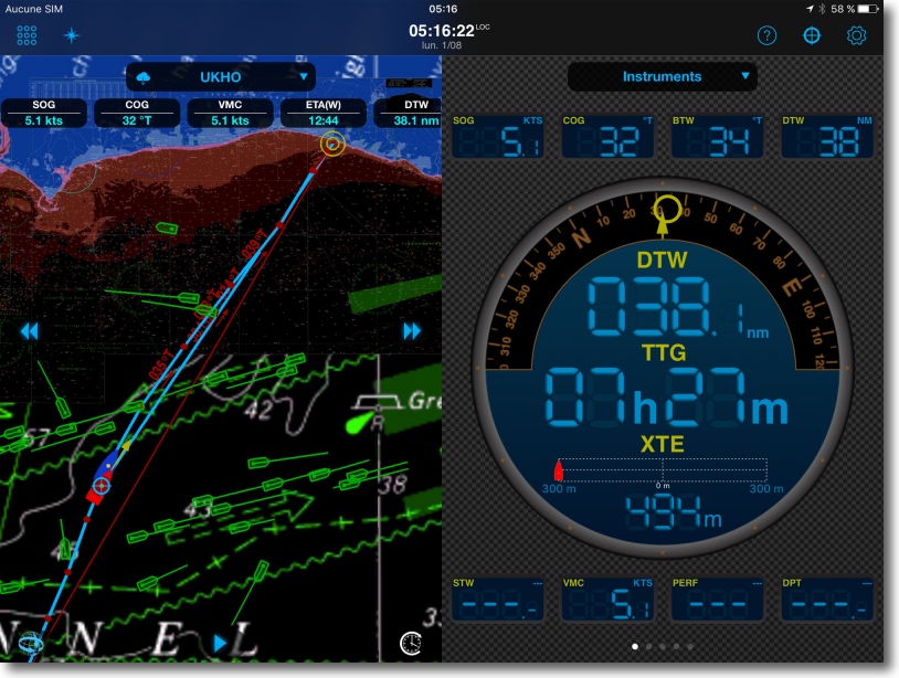
Monitoring route by night combining chart and Navigation instrument in night-view mode
For speed and wind instruments, a short tap on the instrument allows you to select the data to display : SOG, STW, VMC (¹) for speed, APP (apparent) or TRUE (real) for the wind.
Track
Advanced track management has been added. You can enable the track, display it, save it sequentially, then delete it to launch a new track. There is no limit to recorded tracks number. Tracks can be exported and imported in .vdr (specific Weather4D) or .gpx formats. You can customize track color.
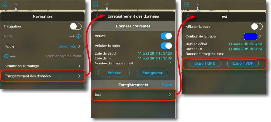 Recording includes all navigation data associated with completed course (NMEA data) by 1 minute steps.
Autopilot control
Now, as with Weather4D Android version, You can control the autopilot by sending NMEA sentences according to route followed to an active waypoint :

A selection of NMEA sentences depending autopilot model
GRIB files requests via SailDocs
Pending full integration GRIB Weather requests to Weather4D 2.0 servers with an Iridium GO! (²), automated request process, via applications XGate or Iridium Mail & Web app, has been added, same as Weather4D Pro. This allows to recover GRIB files GFS and WW3 models available on the American Server SailDocs with a satellite phone.

A tap on the center top banner button opens the page of the GRIB imported from external sources.
The left button "Saildocs" opens a window to create specific zone for satellite phone that, once composed, is sent to the available satphone application on your tablet.
Charting
Good news for Mediterranean mariners, the Geogarage website has negotiated with the Italian company Navimap the integration of their official raster charts catalogue covering in detail all Italy coasts for 50 € annual subscription. The catalogue Navimap is displayed in yellow on the website Geogarage.
 With UKHO covering Spain in part, Balearic Islands and Croatia in detail, SHOM which covers in detail the coast of France and Corsica, Navimap complements the Western Mediterranean basin in detail. It expects that the negotiations for the Greece and the Turkey.
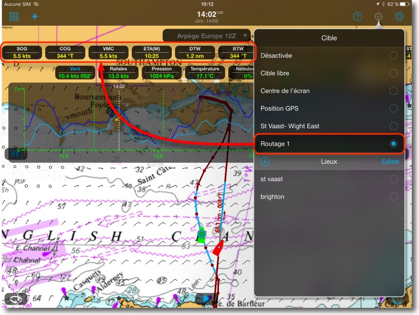
Display simulation data in instruments data labels
Latest update 2.0.16 will respond within a few days of urgent request to see the simulation data and routing in instruments, Alternatively to the actual data. This will be made. The data will automatically appear in yellow (for not to be confused with the actual data in white) as soon as a target will be enabled on the simulated route or routing.
 Here is a set of functions which enrich this amazing application, In addition to 'under the hood' many functional improvements to still greater efficiency.
———
(¹) See free tutorial for an explanation of acronyms.
(²) The APP4NAV company is a developer referenced Iridium GO!, allowing it to integrate the application control of the Iridium GO! and so to manage the connection to its own servers. This opens access to all other models available as ARPEGE, AROME, etc,.
———
Can we finally have the GPS coordinates of the target?
Ask the developer, not to me !
Belles améliorations, la trace est un vrai plus. Dommage que la mise à jour du livre « Navigation et routage météo » ne se fait pas sur iBooks.
If the shift is absent in iBooks > purchases > update, then remove the book and download it again.
Savez vous si les infos moteurs nmea 2000 de type RPM et Fuel rate etc. pourrons être affichés ??
Il vaudrait mieux le demander au développeur ! support@weather4d.com
Effectivement cet email marche mieux 🙂
Réponse ce matin même:
Le fuel rate n’est pas géré car W4d ne supporte pas le nmea 2000 nativement mais via une conversion en nmea183.
Le RPM fonctionne en revanche.
Bravo!! Merci for the update!
Been testing a few days and improvements are multiple. Well done.
My little quibble: the zoom level on which it is possible to cache charts is really to high to be practical for des courses au large
For a short off-gsm-network crossing of, let’s say, only 100 nm one needs to select, at minimum, 6 successive areas to have downloaded the necessary chart tiles. That’s not very appealing and practical.
Dear developers, please add a graphical overview of the charts in cache and/or switch on manual caching at a much lower zoom level. (300x300nm? or more?).
Though it will not stop me from using the app of course. I think it’s brilliant and versatile.
merci
p
Application très sympa. J’utilise encore en double avec iNavx, notamment pour les infos AIS des navires que l’on croise.
Pour la carto je reviens des baléares Ménorque, Majorque) et Barcelone, la couverture UKHO reste très incomplète, pour zoomer je passe sur iNavx avec la carto Navionics. Dommage mais pas du ressort de Weather4D 🙂
To quibble, We should also :
– ability to define the limits of wind downwind speed and at the close for the calculation of the route
– ability to define not only the speed limit of the sailboat (According to polar compared with true wind) at which it was decided to start the engine (in example : below 1.5 knots background one starts the engine…) _And_ to how fast the boat advances with the motor running (in example : 6 knots)
…. to quibble eh.
rectification :
«possibilité de définir les limites de vitesses de vent APPARENT au portant et au près pour le calcul de la route»
(étant donné que la nouvelle version peut afficher la simulation des données des instruments, c’est donc possible 😉 )
..
C’est pour chipoter. Je me doute que les développeurs ne manquent pas d’idées.
En tout cas chapeau bas pour le travail déjà accompli.
Je trouve que différencier la vitesse fond mini à laquelle on allume le moteur, avec la vitesse que l’on fait quand on allume le moteur, manque également cruellement …
BRAVO