
For this 300th blog Navigation Mac entry (Eh, yes, time flies !), I invite you to a survey to find out what charting application is the most used according to the type of practiced navigation. From daily trip to ocean crossing, the need is not the same and this should necessarily guide the choice of the navigation application. But it has yet to prove. Of course we speak here only Apple iOS on iPhone and iPad applications.
After two weeks and 260 answers, here are the results.
• Preamble
The market of yachting in short
Knowing that only 20% recreational vessels registered in France are sailing ships, and that nearly half of those are less than 6 meters high, only 8 motor boats on 10 are also less than 6 meters high (¹), It is logical to think that the vast majority of registered ships is little concerned by this blog. This may explain, in part, the small part of respondents to this survey (12%) for exclusively dayly coastal navigation, mostly practised on sailboats and powerboats registered less than 6 meters high.
The practice of boaters
A study conducted in 2008 by GMV Council (²) practices from 800 boaters, only boats more than 6 meters high, It is clear that :
“Behind the term“ pleasure ”hides a diversity of practices. These different modes of practice combine and are not mutually exclusive : one of the important characteristics of boaters being to be multi-practical. "
This trend in 2008 was certainly confirmed, even amplified so far, especially among younger generations.
Among these practices, 60% boaters are on sailing boats opposit 40% on motorboats. These figures correspond roughly to the registered park, boats being 80% under 6 meters high, actually not falling in this investigation on practices . However it is clear that 53% boaters navigating to the day. Once again, If it eliminates the proportion of motor boats which are used predominantly for the day, found about the survey figures.
• Analysis of the survey
I would remind you that this survey relates only to applications for tablets and smartphones. This survey received 260 responses in two weeks. It is little in absolute terms, in proportion to the potential number of active boaters (³), but significant regarding the "population" of boaters attending this blog.
Navigation areas
Often there were multiple answers to this question. I have however kept for each questionnaire practiced distance farthest, more reliably determines the, or more, application(s) chosen(s).
It is clear that offshore navigation is majority, and strictly coastal navigation little represented on this blog.
Distribution of applications
Here again there are multiple answers, and the sum of the percentages is always greater than 100.
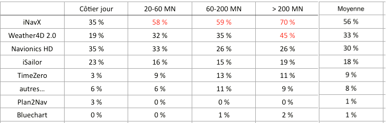
The predominance of iNavX is obvious, and even on par with Navionics HD in coastal navigation, what is surprising. Weather4D 2.0 has taken an important place on the tablets in few time, especially in the high seas. iSailor is still far from catching up iNavX.
However, When you know the sales figures provided by Navionics for its applications, It can be assumed that the largest share is sold to powerboating, its main target, whose followers are almost absent from this blog.
Number of applications used

Almost half of the boaters uses more than one application. This proves the trend to wear 'belt and braces '., for safety to have a choice between two different and/or additional charts. This is also explained by the relative low cost of applications and charts on tablets and smartphones.
———
(¹) http://www.developpement-durable.gouv.fr/IMG/pdf/plaisqqc2014b.pdf
(²) http://www.adt-herault.fr/docs/578-1-atout-france-le-marche-de-la-plaisance-en-france-pdf.pdf
(³) It is estimated the number of active boaters 2,1 million in 2015 (4% of French population + 15 years ago)
———
iNavx, clearly. But I would like to discover iSailor just download. As for W4D, I've not yet tamed the two version and I tend to return to the previous version.
InavX in main tool. I'm currently testing W4D 2.0, but do not know exactly the nature of the tiles in the cache is a major handicap (perdre la connexion internet en cours de navigation côtière « un peu lointaine » est fréquent); If this information, the knowledge of the maps contained in the cache at a time t, is not available in next updates, then I will forsake the Geogarage carto in W4D 2.0 When the subscription renewal, Despite the interest and quality of the product.
Sorry francis but for me it's mac enc on macbook …
For my sailing in the day, OU in coastal, I use IMRAY. Easy, reliable, …
Certainly, not d.optimisation road, but the ballad for, is perfect.
I read very regularly, and therefore, by acquis of conscience and not die idiot, I look at this moment what interest I might have to equip myself of Weather 4 d, that, you read, appears effective …
In addition to iSailor, I use Skipper and SeaIq which allows to use the NOAA raster maps for free. It is spoiled in the USA, because the maps from NOAA, paid by our taxes are set for days and at our disposal for free. Not like SHOM which in addition to finance itself with 100% public fund sell its cards. The French like it pay 2 times for the same thing.
Navionics HD. But I went there is little on Weather4D 2.0, I keep the two in parallel because I need offline operation and at the moment has no list of loaded maps (cache seemingly too weak to handle + Ireland) It is a risk that any sailor can take!
In fact if I checked Navionics and Time Zero , I'm using nav MTZ on PC in raster including his routing module, Navionics duplicate and W4D for weather. I took the habit following two mapping to navigate with the two errors. Sailing South Britain and Scotland and Ireland summer area.
As Henri, I was using iNavx and W4D pro for routes but I went to W4D2.0 I find bcp more powerful and interesting ; however, I'd like a larger cache in order to put more tiles and especially know at all times what is his level of filling ; I'd also like to fill visualize the isochrons in order to take decisions of road beyond the reliable weather forecast periods.
I also thank Francis for the quality of the tutorials
To add to the questionnaire:
What software do you consider switching to? Weather4D
iNavx first and Weather 4 d 2.0 what I am trying to tame and will replace the first that I had also had some time to tame and that I control today on the tips of the fingers…by help and tutorials of Francis