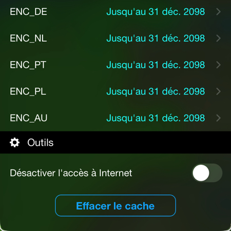
UKHO delays removal of Admiralty paper charts

British backpedaling : UKHO postpones phasing out of Admiralty paper charts until at least 2030 ! Six months after setting the goal of 2026 for the complete withdrawal from production of all paper navigation charts (¹), UKHO (United Kingdom Hydrographic Office) said the 2 February only in response to user feedback, It now plans to continue to provide a paper map service until 2030 at least (²).

Read more …

SHOM removes facsimiles from UK charts

With the latest update of the SHOM the 16 th 2021, Geogarage announces the removal of 18 facsimile charts from British charts covering, mostly, the south coast of England and Gibraltar. These areas are now only covered by the British Admiralty portfolio (UKHO).

Indeed, SHOM recently announced (¹) the rationalization of its catalog of nautical charts, onwards September 2021, by the deletion of many foreign charts reproduced under historical reciprocity agreements with some foreign hydrographic services. Read more …

The S-100 standard for ENC charts is quickly evolving [Update]

in May 1992, the International Hydrographic Organization (IHO) had adopted a standard aimed at defining the specifications of electronic charts, the ENC, used by ships, as well as the devices that display them, Called ECDIS. This standard has been published under the name S-57 – IHO Special Publication N°57. This standard was subsequently significantly updated, The version 3.1, in November 2000. Ten years were then left to the various operators, manufacturers and publishers, to bring their navigation systems on board ships into compliance. In January 2010, A new standard S-100 IHO Special Publication – Universal Hydrographic Data Model has been published, an important evolution aimed at adapting to this rapid growth in the data available for navigation. Read more …

Electronic maps and updates… be prudent !

Over the last few years, I have expressed myself several times on the quality and reliability levels of the electronic charts we use in yachting., more particularly with the navigation applications of our mobile devices (¹).

Since the oldest article in 2013, It appears seven years later that nothing has really changed. On the occasion of a search for a landing in Galicia, I discover that some publishers have still not updated changes that are almost five years old, like the port of A Coruña, which is so busy. I can always be told that the examples I will cite on the West Atlantic coast do not affect safety in any way., But it gives reason to wonder about the rest of the coastline. It should be remembered that SHOM took nearly a year to update on its raster charts the extension of the port of Minimes in La Rochelle, while the German cartographer NV Verlag had long since represented it perfectly on the NV Charts (²). Read more …