
 The October newsletter of WMO (*) announces that sea surface temperatures reflect the intensification of El Niño at the end of the year 2026. The El Niño phenomenon, started in July 2026, continues to intensify, leading to exceptional heat conditions across the tropical Pacific, some coastal areas of South America recording temperatures more than 6°C above average. The El Niño episode is expected to last until at least April 2027 before it begins to decrease.
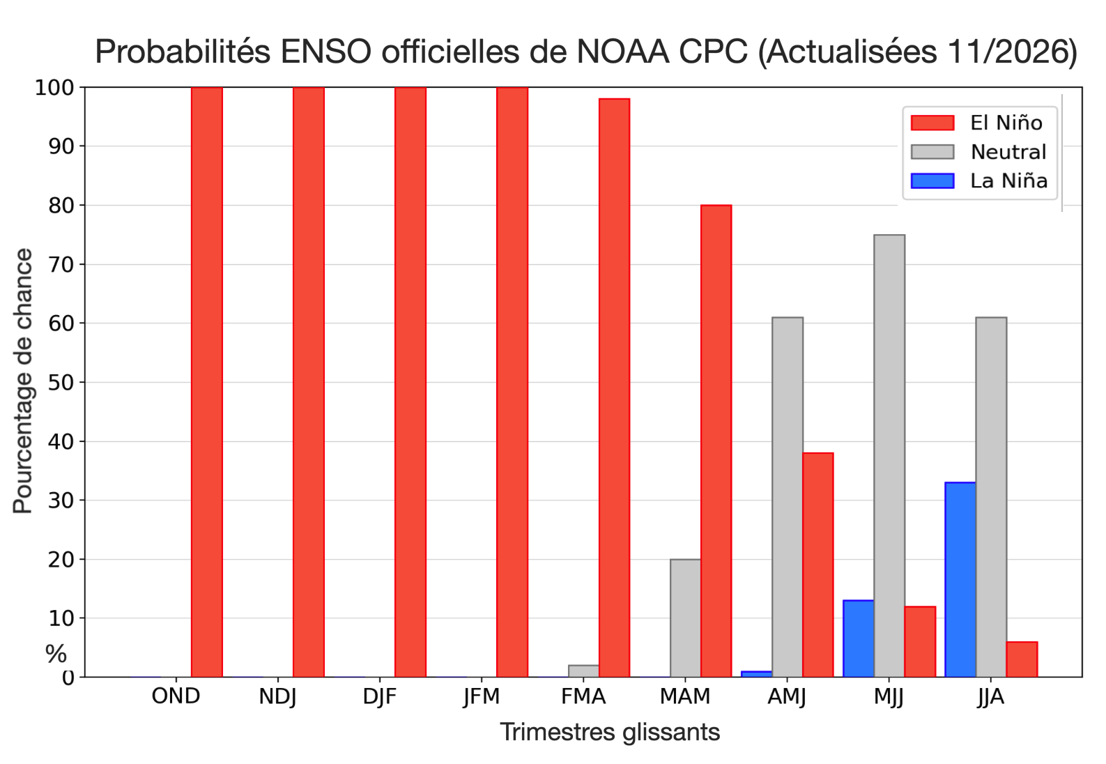
Source: NOAA Climate Prediction Center
" The El Niño phenomenon is well established and intensifying rapidly. WMO forecasts indicate a probability close to 100 % that it persists until February 2027, which would potentially make it one of the most powerful for at least 1950 ”,
said Celeste Saulo, Secretary General of WMO at the Global Heat Forum in Bangkok. He clarified :
" El Niño does not bring additional heat to the planet. It releases heat that the ocean has already stored beneath its surface – which is why an intense episode so often results in one of the hottest years on record, as it was the case in 2024. The ocean from which it draws this heat is the hottest we have ever measured. There is simply more heat available to release. ”
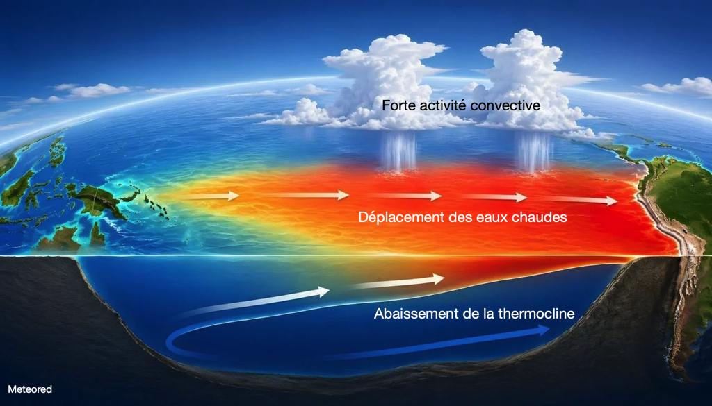
Phenomenon El Niño – Source illustration: METEORED
Sea surface temperatures (SST) worldwide
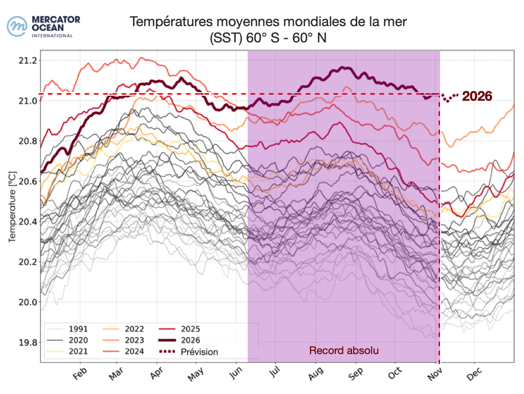
Sea surface temperatures (SST) globally (between 60°S and 60°N) reached a record level for the month of October 2026, with a average temperature slightly above 21°C, thus surpassing the previous record in October 2023. 75% of the world's oceans had above-average mean sea surface temperatures, the hottest regions for the month of October recorded in the tropical Pacific, the subtropical Atlantic and the northern Indian Ocean. Marine heatwaves hit 42% of the planet's oceans, making October the most extreme month on record for ocean heat stress.
Source: EU, Copernicus Marine Service Data © Mercator Ocean.
SST North Atlantic
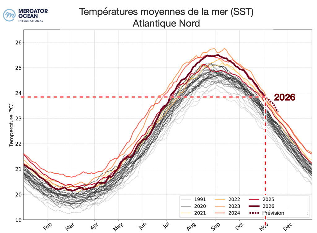
83% of the North Atlantic presents sea surface temperatures (SST) above average, of which 24% exceeding the average by at least 1°C. A broad band of above-average sea surface temperatures extends across the basin, from the Gulf of Mexico to western and northern Europe, where SST reached between 1°C and 2°C above average and locally reached 2.5°C. Off the coast of Guinea, sea surface temperatures are more than 2°C above average along the coast. Only mid-latitudes showed below-average SST, between the Canadian coast and 30° West, with SST locally 3°C lower than average (region called “cold blob”).
Source: EU, Copernicus Marine Service Data © Mercator Ocean.
SST Mediterranean
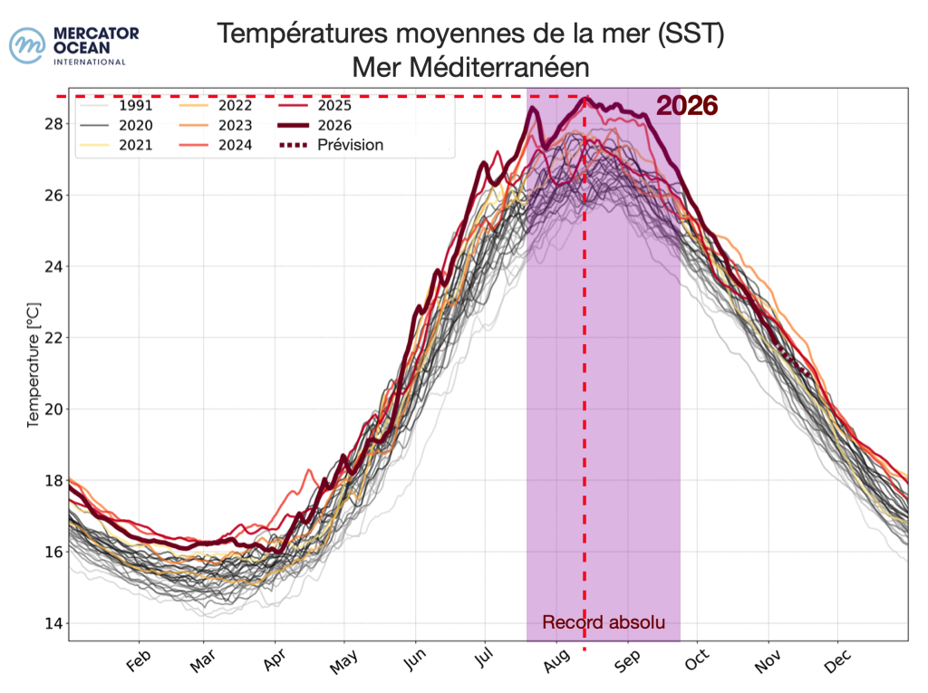
68% of the Mediterranean Sea recorded sea surface temperatures (SST) above average, SST anomalies being more marked in the western part, where they reached more than 2.5°C to 3°C in the Adriatic Sea and along the French coast, Italian and Spanish. 36% of the Mediterranean Sea displays SSTs above average by at least 1°C. The absolute record for average temperatures was between mid-July and mid-September with a peak in mid-August.
Source: EU, Copernicus Marine Service Data © Mercator Ocean.
What consequences for navigation ?
In the Pacific
- Weakening and irregularity of the Trade Winds. Easterly winds may decrease in strength, become more variable in direction and locally move to the west.
- Modification of currents and sea level. Warming of surface waters and west-to-east circulation modify currents and cause sea level to vary locally..
- Precipitation rate. Heat buildup in the center and east causes more convection and gusts in tropical areas near the U.S. coast.
- The oceanic conditions caused by the El Niño phenomenon is favorable for cyclone formation in the eastern and central tropical Pacific.
In the North Atlantic and Europe
- The impacts are less sensitive than in the Pacific, but the phenomenon influences global atmospheric circulation. According to Météo-France, El Niño episodes are accompanied on average by slightly milder and wetter weather in Western Europe at the end of the year and in winter.
- A warmer sea favors increased convective instability, more intense squalls and more violent gales, more irregular local wind patterns, particularly in the Mediterranean.
- On the other hand, El Niño tends to limit cyclonic activity in the North Atlantic by increasing the shear in convective phenomena.
–––
(*) WMO : World Meteorological Office (WMO)
Related Mac Navigation Articles : ENSO / El Niño – La Niña
–––
Cette épisode de El Nino a commencé plus tot et plus fort que les épisodes passés, mais est déjà en train de se contracter.
https://metbob.wordpress.com/wp-content/uploads/2026/11/image-21.png
Bonjour, your comment goes against the majority of global climate forecasters. The graph you oppose does not show that the phenomenon is contracting, look at the evolution of the curves of previous years which also experienced fluctuations in the daily data readings. It is more prudent to wait until December-January to see where the curve will be and if, yes or no, the ENSO phenomenon begins to weaken.