![]() After three years of La Niña phenomenon (¹) in the tropical Pacific Ocean (from mid-2020 to mid-2023) having brought a fairly calm meteorological situation to Polynesia : regular trade winds, lack of hurricane, mainly dry weather, this idyllic situation will be reversed with the announced return (²) of the El Niño phase of the ENSO climate phenomenon (El Niño Southern Oscillation). Finally, idyllic, it wasn't for Southeast Asia, Indonesia, Melanesia and western Australia, which experienced episodes of intense rainfall well above normal and an upsurge in hurricanes during the same period.
After three years of La Niña phenomenon (¹) in the tropical Pacific Ocean (from mid-2020 to mid-2023) having brought a fairly calm meteorological situation to Polynesia : regular trade winds, lack of hurricane, mainly dry weather, this idyllic situation will be reversed with the announced return (²) of the El Niño phase of the ENSO climate phenomenon (El Niño Southern Oscillation). Finally, idyllic, it wasn't for Southeast Asia, Indonesia, Melanesia and western Australia, which experienced episodes of intense rainfall well above normal and an upsurge in hurricanes during the same period.
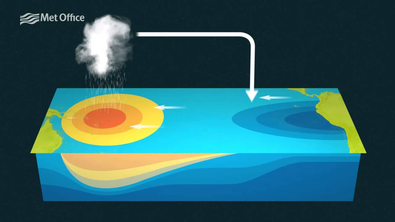
From La Niña to El Niño
WMO published in its 3 May :
According to WMO’s State of the Global Climate reports, based on expert advice and input from the WMO World Long-Range Forecast Centres, it is likely to 60 % whereas neutral ENSO conditions give way to an El Niño event between May and July, and this probability increases to about 70 % between June and August and 80 % between July and September."

ECMWF also published a similar forecast in one of its recent bulletins :

I am not going to give you a lecture on this phenomenon and its consequences on the global climate (³). You will find by Links at the end of the article explanations much more expert than I can provide.
The main purpose of this article is to alert sailors who wish to travel to French Polynesia by 2024 that they could encounter a serious increase in the risk of tropical storms and cyclones, heavy rainfall, erratic or even inverted trade winds. It is therefore necessary to follow closely the information concerning the evolution of the phenomenon in the coming months (⁴), by referring to the bulletins of the organizations links below and all other means of weather forecasting.

Influence on seasonal cyclone activity
Given the uncertainties related to the global climate impacts of the ENSO phenomenon, It can be seen that :
The hurricane impacts of El Niño and its counterpart La Niña are like a see-saw between the Pacific and Atlantic oceans, strengthening hurricane activity in one region while weakening it in the other. Simply put, El Niño favors stronger hurricane activity in the central and eastern Pacific basins and suppresses it in the Atlantic basin – Dr. Gerry Bell, NOAA (⁵)

Typical influence of El Niño on seasonal hurricane activity in the Pacific and Atlantic. From original documents by Gerry Bell
–––
Useful links and sources :
(¹) El Niño and La Niña (Météo-France)
(²) WMO Bulletins
(³) La Niña : What effects on the global climate (Météo-France)
(⁴) WMO : info Niño/Niña
(⁵) Impacts of El Niño and La Niña on the hurricane season (NOAA Climate.Gov)
For English speakers :
–––
Thank you and what about the Caribbean area? ?
I have added an addendum to this article in order to answer this question succinctly.
Thank you, Mr. Fustier, for this very interesting post and the associated links.
Sincerely
Thank you for this important climate alert. Nothing planned for the northern hemisphere ?