
 Following the catastrophic weather phenomenon that hit Corsica on 18 August 2022, causing considerable damage, Météo-France has undertaken to deploy additional resources in the western Mediterranean to better predict the occurrence of such phenomenon.
March, the 5 th 2025, Météo-France has launched the fifth in a series of weather buoys anchored off the coast of France northwest of Corsica. This deployment is part of the reinforcement of the sea observation system, initiated in June 2023, and aims to improve local capacity to anticipate extreme weather events before they reach land.

Position of Météo-France's ODAS buoys in Weather4D (¹)
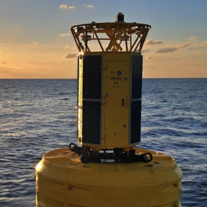
Weather buoys
These buoys are equipped with two independent weather stations, powered by solar panels. Their structure consists of a yellow float, a steel keel and a mast on which sensors are attached. The buoy measures up to 7 meters high (half of which is submerged) and weighs more than three tons. Its anchor line can reach 6 km deep.

The anchored buoy allows you to measure and transmit weather parameters such as wind in real time, air temperature, air pressure and humidity, but also ocean parameters such as wave height and frequency, the temperature and salinity of the sea. These recorded data feed into various numerical models used by Météo-France forecasters.
Strengthening observational data
This infrastructure aims to improve the coverage of sea surface observations in this region, as well as weather monitoring and nowcasting such as the arrival of a thunderstorm. During hazardous weather events, storm, Mediterranean episode, Medicane, The data transmitted by the buoys will be essential if the weather scenarios diverge on the intensity and location of the phenomenon. The data transmitted in real time will make it possible to confirm or refute a scenario and to retrace the episode on the basis of proven observations.
Significant results
The first buoy deployed in June 2023 provided important information during the severe thunderstorms that circulated on the 27 and 28 August 2023 in the Mediterranean. The scenario chosen by forecasters predicted a passage of the storm to the south of Corsica, with strong gusts expected on the island. The data transmitted by the buoy during the advance of the storm confirmed the trajectory and intensity of the storm. An orange warning for thunderstorms had been issued for Corsica.
The buoy data also provided a better understanding of the violent episodes that affected Corsica in the autumn 2024 and have been a valuable aid for risk estimation in the Provence-Alpes-Côte d'Azur region. This was the case, in example, between the 15 and the 18 October 2024, during a stormy deterioration that gave very large accumulations of rain over a large part of the territory, leading to sometimes devastating floods, Particularly in the south-eastern quarter where six departments had been placed on red alert for rain-flooding and/or flooding on Thursday 17 October.

Wednesday rainfall totals forecast 16 to Friday 18 October 2024 – Credit meteologix.com
Also, The reinforcement of buoys proved useful during the Mediterranean episode of the 24 until 27 October 2024. This episode was distinguished by its duration and the gradual accumulation of rainfall over several days. The coastal departments were the most affected, in particular the Var and the Alpes-Maritimes.
–––
Source : Météo-France

–––
(¹) Buoy file to be opened in Weather4D
–––
Est que on sait quelle modele utilise les donne des balises? Arome, Arpege….
To ask the question is to answer it ! Aroma for sure, Arpeggio most likely.
Merci
Indeed since now 15 years I see an evolution in the suddenness and violence of these worrying episodes.
I hope it will be a way to navigate these wonderful waters more safely.
This is the reason that pushed me to publish my textbook on the weather in the Mediterranean, at the end of a training course given in Marseille in 2023.
How were the risks of collision apprehended ? Prevention and depreciation?
ODAS weather beacons (Ocean Data Acquisition System) are shown on nautical charts, and filled in beforehand in the GANs (Notices to Mariners Groups).
Bravo and thank you to the Météo France teams who show the way to the clowns who are getting.