
With the advent of powerful weather-routing applications on our tablets and smartphones, as Weather4D and SailGrib WR, at truly affordable prices, routing is becoming more popular for pleasure boating. The quality of these applications is already appealing to amateur sailors, and even some high-seas professional riders, but also a growing number of leisure boaters. Riders use the routing in the essential interests of performance, Achieve the fastest route from one point to another, so leisure boaters are more focused on getting safer and more comfortable routes. For them, The notion of speed is mainly used to avoid periods of bad weather, and the optimized route to escape areas where sea and wind conditions can be dangerous. Routing is also used for this : even in powerboating, you may try to avoid too much wind speeds or wave heights to ensure ypur crew comfortable and serene trip. But what credibility can be given to routing ?
Can we believe in routing ?
I see, to browse a number of forums devoted to marina navigation, as much in France as in front-Atlantic, that many practitioners throw themselves on this tool in a somewhat blissful way, and without really taking the measure of its limits. It seems to me important to remember that the routing is but a tool to help in the boater decision, of which all components are based on hypothetical predictions : weather, currents, speed polar, which makes it perfectly random, therefore requires an absolute caution.
• Weather and current forecasts :
Huge progress has been made for several decades to predict the time it will do on the planet, on land and sea, with the main purpose of preventing natural disasters, but also to meet the requirements of air and sea traffic, Rail and road, to agriculture and how many other uses. The boaters therefore have increasingly reliable weather forecasts, For increasingly reduced areas. Some forecast models can provide data with 1 km resolution, one hour steps. at range of 24 to 36 hours steps, all the 4 km range up to 48 hours steps, 16 km range up to 96 hours. This is called Fine grid models (¹). The so -called "global" models that can cover the world offer forecasts for shipping with large grids 30 to 120 Nautical miles range 8 up to 16 days. This is the case of the NOAA GFS model(¹) distributed for free worldwide. These long -term models have reliability for large areas that can be approximately qualify as 90% to 3 days, 50% to 5 days, and trend beyond. They allow you to see the distribution and evolution of phenomena, across the North Atlantic in example.
Forecasts of ocean currents and tidal streams , as reliable, are now available, from Australian society TideTech or European organization MyOcean (²) frequently mentioned on this blog. These predictions for several days for ocean currents are reduced to a few hours for coastal currents with high resolution, but are still not approaching a sufficient accuracy for local tidal streams.
• speed fleeces
Speed fleeces generally come from specialized programs called VPP (³) combined with naval architecture programs. They are most often provided by architects or boatyards. Boredom is that they are perfectly theoretical, and can be easily degraded depending on the charge of the ship, the state of the sails and the hull cleanliness, the quality of the coxswain (the autopilot so), and a thousand other factors reducing theoretical target speeds. Routing applications, for this reason, generally offer the possibility of applying a global fleeing minor coefficient. All this brings a certain factor of imprecision.
Routing, distance and grid
The implementation of routing requires a certain common sense. It should be kept a reasonable proportion between the distance and the resolution of weather file used. To exaggerate, A course of 60 nautical miles with a GFS file at 0.5 ° (30NM) Can never give a relevant routing. It goes without saying, but still worth saying. If it only does have such a file, one can reasonably optimize only a road comprising at least 10 grid points, at least 300 nautical miles, but never routing a trip around Belle-île island, As I read somewhere. It doesn't make sense !
In the examples below I compare a routing on a theoretical course of 150 NM, with a GRIB GFS 0.5° and a GRIB high resolution WRF France 0.04° (2,4 NM)

With GFS file without current data, routing brings a gain of 5 Direct road hours, But pass through a strong wind zone.
The above optimized route shows 23 waypoints corresponding to 23 calculation isochronous. We see that there is between 3 and 4 isochrones between two grid points, The calculation must therefore operate a linear geometric data interpolation and a temporal interpolation between two grid points. Constant wind and current, this provides little impact on the result, but if the variations in strength and direction are important along the way, The result can be significantly distorted.

With the WRF France file, the route is more accurate in following more closely wind changes but does not avoid the area of strong winds.
With high resolution, in approaching more direct route, We see that the gain is only to 2 hours on arrival. Is routing to be followed ? In this case the direct route, A little slower but made in mid -wind conditions, isn't it better ? For my own this is the choice I would do, except indead if I was in regatta. But I am on a cruise and I don't want to tire neither the boat nor stomachs. It is therefore always necessary to have a very good reason to deviate from the direct road !
 Just compare the grid of two files to be convinced of the proportion necessary to keep between the distance and the resolution of the model to use :
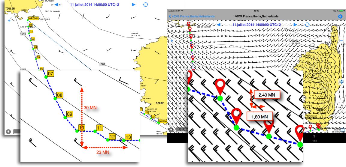
By enlarging the card, we see that a large density of data between two isochrones allows a more precise calculation, Especially if the data vary over the course.
I would like to quote Pierre Yves Goemans, a Belgian sailor familiar of navigation areas with strong currents and frequent changes in weather, who wrote on his blog last year:
So should we believe in routing on a scale of a few hundred miles?
Yes provided that they do not use the results of how more accurate that are data ! The big lesson I withdraw from this first experience, is that you must be able to analyze the results and understand the road options proposed by the tool, In order to make the strategic navigation choices, taking into account the uncertainty inherent in the data ... such a daring option, to the coast or the sea, She remains valid if the wind turns a little or has a somewhat different force? Question to which it is not always easy to answer ...
Wise reflection that I offer to everyone's meditation, and that I will not fail to remember.
—
(¹) See the entry "Forecast Models" in the Glossary.
(²) Weather4D Pro still improves routing
(³) Velocity Predicting Program
—
Relative article :
ENCs, Routing and sailing shaves stone
—
As always Francis, Thanks for your right classes on the modern navigation technique based on the high technologies of current computer science introduced into your blogs.
A.B.V.
Thank you again Francis for the whole sum of free information provided in your blogs.
Sincerely,
Philippe
It is always a pleasure to read the measured and enlightening comments of this excellent blog.
Thank you Francis