
 An exponential number of cases of jamming and spoofing of GPS signals has been observed throughout the world in recent years. Whether due to conflicting states, to terrorism, or simply by using a jammer accessible to anyone on eBay or the Dark Web for less than €100 ! Our modern world is based on a frighteningly fragile system, extremely vulnerable to jamming, signal spoofing and the threat posed by anti-satellite weapons. Simply consult the site in real time gpsjam.org to convince yourself (¹). Read more …
Category : Navigation
Articles related to maritime navigation
Navimetrix provides ensemble routing and much more…
![]() With the brand new update 1.9 NavimetriX brings, among other new features, a high-level routing function : the overall routing. Read more …
With the brand new update 1.9 NavimetriX brings, among other new features, a high-level routing function : the overall routing. Read more …
THE U.S. Navy returns to sextant
In the age of AI, dual-band GNSS and inertial units, the U. S. Navy returns to good old fundamentals by encouraging its sailors to practice celestial navigation. To prevent jamming, spoofing, or even a hypothetical total electronic blackout, US Navy commanding officers and navigators must master the dead reckoning and handling of the sextant. Excerpt from an article from U.S. Naval Institute freely translated and adapted (¹). Read more …
NavimetriX, universal navigation
![]() NavimetriX is the world's first navigation application featuring a unified, cross-system 3D GUI, synchronized in real time across all devices.
NavimetriX is the world's first navigation application featuring a unified, cross-system 3D GUI, synchronized in real time across all devices.
The new navigation and weather-routing application NavimetriX was just published. Result of long development work, this application revolutionizes navigation on mobile as well as fixed devices with its universality. It indeed offers a unique user interface, with elaborate graphics, for all operating systems : macOS, iOS/iPadOS, Android and Windows. In addition, regardless of the devices used, a single account allows full settings and data synchronization . Read more …
New tutorial : Weather in the Mediterranean
March, the volume 2 from Introduction to Marine Weather has been published on the iBook Store (Apple Books)

The Mediterranean Sea has a unique configuration in the world. An enclosed maritime area of nearly two thousand nautical miles from west to east, it is only open to the Atlantic by a strait of eight nautical miles. Read more …
BBC Radio 4 – The Shipping Forecast celebrates its 100 years old
![]() 2025 marks the 100 years of the broadcast of marine weather forecasts The Shipping Forecast on BBC Radio 4. This emblematic transmission, produced by the UK Met Office on behalf of MCA_media, continues to be a vital safety service for mariners along our coasts.
2025 marks the 100 years of the broadcast of marine weather forecasts The Shipping Forecast on BBC Radio 4. This emblematic transmission, produced by the UK Met Office on behalf of MCA_media, continues to be a vital safety service for mariners along our coasts.
I had written an article at the beginning 2010 (¹) on the gradual disappearance of radio weather forecasts in France, and praised the consistency of the BBC bulletin. Fifteen years later, the marine weather forecast is still broadcast on BBC Radio 4 Long Waves at the same unchanging times. Hats off ! Read more …
The magnetic north pole is on the move [Update-2025]
Earth's magnetic north pole is rapidly moving away from the Canadian Arctic towards Siberia. NCEI scientists (¹) updated the global magnetic model (WMM) 2025.

The position of the geomagnetic North Pole is 80.8°N in latitude and 138.6° E in longitude
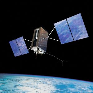
Galileo completes his constellation [Update]
 March, the 5 th 2024, the last two satellites launched during the 12th launch of Galileo the 28 th, were officially integrated into the Galileo constellation, thus ensuring the sustainability of all services in orbit.
Now Galileo has 25 operational satellites out of 30 satellites placed in orbit. 5 satellites being currently considered unusable for some or unavailable for others (¹). Read more …
Bloc Marine is back
![]() First appeared at the end of June 2023, l’application Bloc Marine, edited by Weather Consult / Le Figaro Nautique, has replaced the Guide Escales (¹), previously removed from the Apple Store. This latest application was far from unanimously accepted following a catastrophic pricing policy over successive updates. (²). Read more …
First appeared at the end of June 2023, l’application Bloc Marine, edited by Weather Consult / Le Figaro Nautique, has replaced the Guide Escales (¹), previously removed from the Apple Store. This latest application was far from unanimously accepted following a catastrophic pricing policy over successive updates. (²). Read more …
R-Mode, future alternative to Positioning System
Global navigation satellite systems GNSS (Global Navigation Satellite System), have become the primary source of Positioning, Navigation and Timing (PNT1) for ships and marine operations. GNSS is also used for the automatic identification system (AIS2). Unfortunately, GNSS is recognized to be vulnerable to jamming and spoofing, intentional or not, that may result in the loss of positioning information, or, still worse, inaccurate positioning information. Read more …