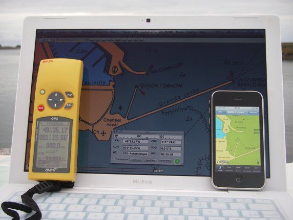
Many wonder about the accuracy of the GPS built into the iPhone, and therefore on the reliability of iNavX.
So I did a little comparison, staging :
- A MacBook with MacENC + GPS antenna BU-353
- An iPhone with iNavX
- An (old) MLR SP24 with its formidable precision
Placed in the extremeness of a mole of 2 meters wide, the three devices gave exactly the same latitude and longitude, minute (click on pictures to enlarge) :
Or 49 ° 35′,17 of latitude and 1 ° 15′,66 about longitude. For Macen and Incax, The position icon (the point at the top of the triangle representing the ship) was placed on the end of the mole, Precisely for Incax using the vector cartography Navionics Gold+, down to 1 or 2 meters near for Macen using, for this test, my old raster SHOM charting 1998 (From, I bought the Navionics Gold charts for MacENC).
However, if the iPhone GPS accuracy remains largely sufficient for yachting, He has the big defect not to have a WAAS/EGNOS reception channel (*) allowing permanent correction of the GPS position. The result is that the receiver "picks up" regularly and then presents a fanciful position, for a period of a few seconds until 1 or 2 minutes (**).
Despite this, in most cases in navigation, the built-in GPS of the iPhone has an accuracy quite sufficient, the open-stones in the mist with GPS is particularly not to recommend !
To conclude, I give you a testimonial received last summer from a visitor to my website :
This summer I went to the Red Sea, as a cruise of 15 days for diving. The boat was obviously armed by the Egyptians. I had bought the Navionics African card for a modest sum for the iPhone and, for this reason, I had much more nautical information than the captain who was really amazed ! Almost all coral reefs that we had explored were on chart and the coupling of the application with the GPS of the iPhone has proved very effective.


Hello Francis,
"He has the big lack of not having a WaS/Egnos reception channel"
I am a little surprised by this assertion, What source comes from ?
Because the GPS Broadcom BCM4750 chip contained in iPhone is able to manage 24 signaux satellitaires simumulaténement.
Gold, les corrections WAAS/EGNOS sont envoyées sur la bande GPS normale (L1, 1575.42MHz) 😉 .
Mes tests comparatifs effectués entre un Garmin GPS 60 et iPhone était clairement favorables à iPhone en tout cas et surtout il avait un bien meilleur time-to-first-fix (TTFF) grâce aux AGPS(Assisted GPS) et LTO (long-term orbit)
Bravo pour ton Blog, c’est une très bonne idée !
Friendly,
— Loïc
ps : http://www.egnos-pro.esa.int/ESTB-EGNOS%20FAQ%2017%20May%2006.pdf
Après avoir interrogé Broadcom, il s’avère que cette société a fourni le module combo BCM4325 WiFi 802.11a/g/b et Bluetooth 2.1 mais pas le chip GPS. Celui-ci pourrait être le PMB2540 de Infineon/Epson, ou bien toujours le PMB2525 qui équipait déjà l’iPhone 3G. I will soon make an additive on this subject when I have enough information.