
 An exponential number of cases of jamming and spoofing of GPS signals has been observed throughout the world in recent years. Whether due to conflicting states, to terrorism, or simply by using a jammer accessible to anyone on eBay or the Dark Web for less than €100 ! Our modern world is based on a frighteningly fragile system, extremely vulnerable to jamming, signal spoofing and the threat posed by anti-satellite weapons. Simply consult the site in real time gpsjam.org to convince yourself (¹).
Time to upgrade to new technology ?
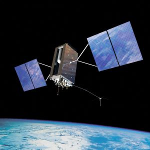
GPS is not just a map positioning tool, it is above all the invisible metronome of the modern world. Atomic clocks on GPS satellites synchronize cellular networks, timestamp billions of financial transactions to the millisecond and regulate electrical networks. If the sync signal were to disappear, our global digital infrastructure would completely collapse. We linked the pulse of the global economy to a barely perceptible radio signal from space. It would be urgent to free ourselves from it.
-
Strategies diverge
The American government focused its response almost exclusively on strengthening military resilience measures, such as encrypted M-code signals and anti-jamming antennas. But this does not help commercial transportation or global logistics networks that must operate in environments where access is restricted.. The United States considers GPS a purely military asset.
China took a radically different approach. It injected massive public investment into the BeiDou satellite system, which has achieved complete global coverage in 2020 and whose scale exceeds that of the American network. Simultaneously, it reinforced BeiDou with a multi-level terrestrial architecture including a fiber optic network of 20 000 kilometers and a national eLoran system. By actively exporting BeiDou under the Belt and Road initiative and achieving complete autonomy in domestic production of navigation chips, China is building an ecosystem with commercial and strategic leverage that will become more important as GPS-deprived environments become the norm.
 Europe, on his side, with the mission Celeste from l'ESA, intends to complete its Galileo constellation with a program of 11 low orbit satellites (LEO) in order to test a multi-layer and multi-frequency system aimed at optimizing the provision of services, to strengthen the overall resilience and robustness of PNT systems (²). The first two satellites are planned for orbit at the end of March 2026.
-
Beyond GPS 2.0
Satellite constellations that simply come closer to Earth (LEO) GPS type instruments, such as Iridium with Satelles Co (³), or the ESA with Celeste, have many of the same vulnerabilities as the system they are intended to replace or improve. But to compete with the “free” solutions that States provide today with their multiple constellations, revolutionary innovations will be required, and not simple incremental improvements.
What alternatives ?
-
Innovative initiatives
New start-ups such as EarthTraq aim to fill these gaps by proposing new, specially designed constellations, associated with inexpensive, low-power devices that do not depend on any GPS constellation.
Other companies rely heavily on computer vision or radar to automatically determine their position using what can be called “artificial intelligence dead reckoning navigation.”.
Giants such as Vantor et Niantic Spatial rely heavily on high-fidelity photogrammetric digital models of the world to enable precision navigation in difficult-to-access environments.
Another example, Skyline Nav AI uses computer vision and deep learning to determine a vehicle's position in real time based solely on its surroundings.
![]() Also, the European start-up Vydar uses onboard AI to match live ground camera footage with offline maps, thus calculating very precise coordinates even in the event of a total GPS shutdown.
Also, the European start-up Vydar uses onboard AI to match live ground camera footage with offline maps, thus calculating very precise coordinates even in the event of a total GPS shutdown.
-
The future
All these solutions, among others, offer operational performance that GPS cannot match and seem very promising to complement or replace it in a hostile environment. We will all have to get used to a world without GPS. The days of blindly trusting a single vulnerable satellite network are over.
If we want to safely operate autonomous systems and AI in the real world, we need to develop more precise positioning methods in an absolute reference frame, which cannot be circumvented by simple cheap jammers bought on eBay. It's time to make the system resilient, redundant and reliable through other means, to make AI-driven autonomous navigation a reality.
-
What about recreational boating ?
A majority of boaters sail in low-risk regions — except for the Baltic countries — far from conflicts. The multiplicity of networks accessible to our navigation devices, with more than a hundred satellites, allows us to hope for the guarantee of reliable positioning. The fact remains that wise caution should make us follow the measures recently taken by the U.S.. Navy on some of its units, which I echoed not long ago. Redo learning navigation by dead reckoning, for coastal cruising, and astronomical navigation for the open sea.
––––
(¹) Source Pulse, freely translated and adapted. Relayed by Geogarage Blog.
(²) See Glossary “Satellite” section.
(³) Iridium Communications acquires Satelles
–––