 I've been asked this question regularly, but until now I've never wanted to give my opinion on the subject publicly, so as not to offend anyone or create unnecessary controversy.. But after doing so many of my training courses, why not express it to me openly ?
My opinion, forged by observation and a long professional experience in pleasure boating (¹), is that this assertion of the systematic optimism of GRIB forecasts regarding wind strength, which unfortunately persists, no longer has any reason to exist, and has not been verified in practice for some time.
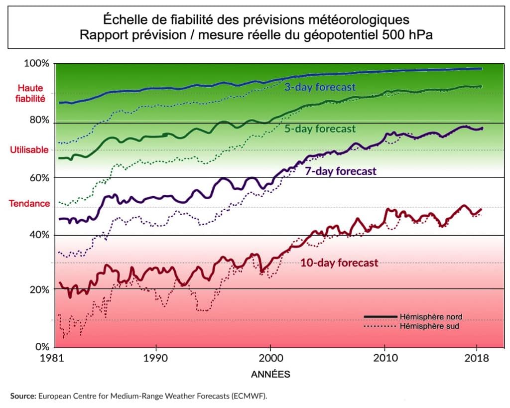
First of all, because weather models have made enormous progress in reliability over the last few decades. The atmospheric and oceanic data collected have increased considerably, thanks to the proliferation of specialized satellites, increased maritime and air traffic, the significant increase in data sensors of all kinds. Forecasting models have benefited from the exponential power of supercomputers and the growing skill of forecasters around the world (²). What if the wind strength forecasts were always systematically optimistic, it seems obvious that this would not have been missed by the forecasters, The models would have been corrected a long time ago (³).
Then the average to average winds 10 meters high forecasted in the GRIB actually represent an average. And for any statistical average there are deviations from the mean (Standard deviations) more or less. Negative gaps in wind strength are of little importance, it is the positive gaps that matter to us. In this sense, systematically increasing the wind strength of the GRIBs was not totally wrong in the past, although the systematism is overstated. Because the amount of gap depends to a large part on the weather conditions in which we are, and is directly linked to stability. (High Pressure) or instability (Low pressure) of the air mass present. The gaps will be greater as the air mass will be unstable. A contrario, there is little correlation between the value of the gap and the strength of the average wind.
To overcome this inaccuracy, for a few years (2012) GRIB models provide, in addition to the forecast for the average wind to 10 meters high, those of the Risks of gusts (⁴). We then obtain a reasonable range between the average wind and the maximum winds that we are likely to encounter. This turns out to be, All models combined, highly efficient, especially in very disrupted situations (Storm cells, cold and occluded fronts for example).

On the left, the color gradient represents the average wind speed. On the right it represents the gap between the average wind speed and that of the gusts. In the meteogram the average wind curve is drawn in light blue, that of the bursts in dark blue.
In the example above, we notice, to the position of the target when a cold front passes, that the greatest value of the mean wind-gust gaps does not occur when the mean wind is the strongest, but when it decreases in its rotation behind the front (Left window). The gap value then goes from simple to double (Right window) : 21 knots up to 43 knots.

For the same average wind speed, The gap with gust speed has completely narrowed in a stabilized system.
36 hours later, at the location of the target, the air mass being much more stable, the gap between the average wind speed, same as the previous situation, has been considerably reduced (21 knots up to 27 knots).
Thus, the assertions still made by some recognized specialists in marine meteorology, with all due respect, seem to me to be obsolete. For my own, since the availability of this "Gusts" data, both in the Atlantic and in the Mediterranean, I have almost always found myself sailing in the range of these two values.
However, Sailing close to shore, Care must be taken to use a weather model with a sufficiently high resolution to take into account the effects of thermal wind, which can be strongly combined with synoptic wind. This is the case of thermal breezes, accelerations by the Venturi effect when passing certain capes, katabatic winds that can generate strong gusts, aso. In France, only the AROME model knows how to take these phenomena into account. But this does not mean that the forecast values for the average wind are optimistic, or even false.
Learn more, I advise you to look at (in full) Christophe Asselin's excellent video on his YouTube channel : Why is it so difficult to predict tornadoes ? (and time in general).
–––
(¹) https://francis-fustier.fr/formations/#expertise
(²) https://www.noaa.gov/stories/weather-prediction-its-math
(³) View ongoing evaluations by CEPMMT.
(⁴) https://www.navigation-mac.fr/weather4d-apporte-encore-plus-de-finesse/#rafales
–––


Bonjour,
An excellent article (as usual) and which this time twists the neck of preconceived ideas and many pontoon noises.
I took the liberty of putting a link on our club's website to share it with our teammates.
Many thanks.
Kind regards.
Hello Francis
Excellent article that summarizes and shows the qualities of the weather.
I would add the Swiss model with intelligence based on past developments in the same current conditions and on dynamic calculation models.
NEMS (NOAA Environment Modeling System).
It focuses on Western Europe, with the advantage of awakening our minds because it is different from others. Be careful, it is specialized for the mountains, so the influences of thermal breezes are not necessarily good for the sea .
Thank you Francis