![]() NavimetriX is the world's first navigation application featuring a unified, cross-system 3D GUI, synchronized in real time across all devices.
NavimetriX is the world's first navigation application featuring a unified, cross-system 3D GUI, synchronized in real time across all devices.
The new navigation and weather-routing application NavimetriX was just published. Result of long development work, this application revolutionizes navigation on mobile as well as fixed devices with its universality. It indeed offers a unique user interface, with elaborate graphics, for all operating systems : macOS, iOS/iPadOS, Android and Windows. In addition, regardless of the devices used, a single account allows full settings and data synchronization .

NavimetriX on macOS (Large screen), Windows (MacBook), Android Samsung (TabS5e), iPad (9e gen.), iPhone (12 Mini)
A little history
Let's remember, in October 2022, Henri Laurent (SailGrib) and Olivier Bouyssou (Weather4D) come together to create eSail4VR, application dedicated to gaming Virtual Regatta. The application is already a revolution because it is multi-platform, synced across all devices, with a 3D interface of the most beautiful effect. It is published the day before the start of the Route du Rhum. Acclaimed upon its release, it will be boosted with the Vendée Globe 2024, used by thousands of players to whom it provides crucial decision support thanks to an expert routing engine, equipped with numerous fine adjustments, while remaining easy to use for a novice. The two friends will not stop there, this will be the mock-up of the future real navigation application. Three years of developing and implementing a high-level back-office infrastructure and NavimetriX was born.
Multi-supports, multi-OS, unified navigation
NavimetriX works with the following operating systems and processors :
- macOS : Version 13 and higher, x86_64 processors, x86_64h one arm64. Compatible with macOS Monterey (released on 25 October 2021) and all later versions.
- Windows : Version 10 ("build" 1809 —10.0.17763) or higher, Windows 11 (all versions), x86_64 and arm64 processors.
- Android : Version 9 (API 28) down to 15 (API 35) – arm64-v8a, x86_64, x86, and armeabi-v7a, Android 9 released in August 2018.
- iOS : Version 16 or higher, processors – armv8, poor64.
These operating system versions are prerequisites for running NavimetriX, corresponding to compatibility with development tools. However, they do not guarantee that the application will be fully compatible with the multiple devices present on the market.. Many other factors can influence performance and compatibility, like insufficient RAM memory, a mediocre graphics processor, aso. NavimetriX requires significant graphics and functional capabilities. It is prudent to take advantage of the free week to test all functions available.
Synchronized
Synchronization works in real time if devices are connected to the same Wi-Fi router, on land and sea. Most settings made on one device are immediately activated on others, except some which must be adapted locally depending on such a mobile. Numerous parameters allow you to customize according to the characteristics of the boat used, up to the ship icon which can take the form of a monohull, of a catamaran or a trimaran. GRIBs downloaded, POIs, routes and routings, are also instantly synchronized : no more tedious re-entry from one device to another.
All these features, to which is added the download of weather files and charts, are supported by a powerful, high-availability server infrastructure (¹), adapted to cope with large volumes of transfers. Already functional for a few months for Weather4D, SailGrib and eSail4VR, this infrastructure has been subject to specific security measures capable of ensuring continuity of service to users.
Weather routing, spearhead of the application
The routing options and settings have been enriched by the work carried out for eSail4VR with expert mode, and also developments made in SailGrib through the experience of racing-cruising. There we find the pivot points, exclusion zones, the lens zones, and numerous advanced settings for a high level of precision. Generating a routing table is automatic, accompanied by a table of TWA/TWS cross statistics and even the creation on demand of a AI-generated briefing. This detailed analysis contains a link opening a frontology map covering the relevant routing area from NOAA, and also the bulletin Mer from Météo-France.
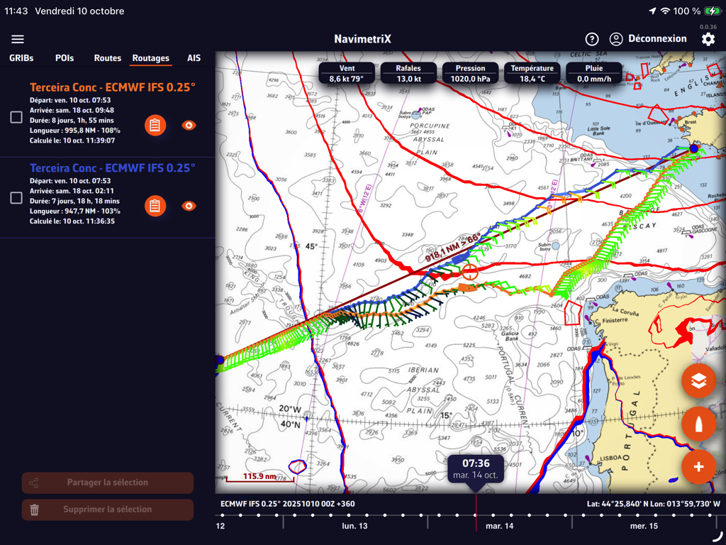
Routes with an option from a pivot point
NavimetriX takes the best of the two applications Weather4D and SailGrib, in a high quality graphical interface, and much more : wind display choice of animated particles or vectors/barbules, Timeline for scrolling forecasts and simulated boat progress on routes and routings, tide gauges, pull-out side drawers, aso.
Charting
Like Weather4D and SailGrib, NavimetriX uses the cartography provided by the platform Geogarage under the same conditions. This cartography, based on data from official hydrographic services – more than twenty worldwide – is updated approximately four times a year. A complementary vector cartography offer should see the light of day soon.
Where ? When ? How ?
NavimetriX is available for download on all four stores : Mac AppStore, App Store, Google Play and Windows Store, or directly from the application website. The download is free, all options usable during 7 days, then in a free degraded version, or in full version by auto-renewable annual subscription at the price of 79,99 € .
The first version 1.0 will include all essential functions, more than many functions are already under development which will enrich the application in the coming months.
It is important to note that NavimetriX is a new application developed, just like eSail4VR, by the company SOFT4SAIL. It does not replace SailGrib, Weather4D, which remain maintained and supported, but which will no longer receive any major developments in the future. There is no link between these applications apart from the import-export of data.
–––
(¹) The back office
–––
Bonjour,
It’s attractive but at €80 for the app plus €60 Shom card plus €70 for UK equals more than €200 per year…
You take us for Americans o)
Good luck, but without me…:)
Weather4D is a paid app for €65 + weather subscription €46 + the same map as NavimetriX. SHOM + UKHO €130 to have 1690 charts, even if you only use 10%, compare with a paper map between 34 and 38€/unit. NavimetriX is free in basic version, the annual Premium subscription can be easily deactivated when the basic functions are sufficient. The “Americans” are those who buy TimeZero on PC + Carte Europe + Routing + Premium Weather = 1147 € ! That being the case,, you can settle for OpenCPN…
Je ne savais pas que W4D coûtait 65€ par an… 😉
There are some great features in this new software. A great “programmer’s trip”…
However, I am quite surprised to see that support for vector maps is not available from the version 1.0.
NOAA, like other hydrographic services, no longer distributes raster maps since 2021, and it has already been several months since the raster mode mapping files have been stopped being updated.
Unless I'm mistaken, the main target audience remains the boater, who is especially looking for clear and fluid cartography – a bit in the Navionics spirit – with possibly simple weather routing to prepare for navigation.
Advanced routing, which requires time and good control of the parameters, is aimed more at professionals. For my own, on a sailboat moving forward 6 knots, I prefer to enjoy the landscape !
And on major crossings, a little anxious by nature, I prefer to entrust the routing to a professional for a few days, just to sail with more peace of mind.
Regarding cartography, Geogarage has been converting ENC maps for two years, which are gradually replacing rasters from disappearing paper maps.. The integration of C-Map maps should not be completed for a few months for technical reasons of graphic adaptation to a spherical display. But it will happen. For routing, it is obvious that the choice of a navigation application must meet very personal criteria. NavimetriX, just like SailGrib and Weather4D, do not address the same needs as Boating, TZ iBoat or inavX.
Thank you Francis for this good news.
Is there a comparison table of the features available on the basic version (degraded version) and the full version?
Friendly
DD
Oui, it's in the section Subscription on the home page of the navimetrix.com website.
Hello Francis
Thank you for this new article on NavimetriX, which the press has been talking about since the beginning of summer.
Tout comme Weather 4D, will you be in support for this new application ? (manuel, FAQ,…)
Weather 4D fan for over 10 years old, the positioning of this new application is currently difficult to understand, except that it will eventually replace (2 years old, plus ?) Weather 4D because I can easily understand that the cost of maintaining several such similar software weighs on profitability.
Reply sent by email.