
A recent Thread on the Hisse Et Oh forum, I salute by the way, I challenged the accuracy of the chart data provided on the electronic charts. The subject concerns the observation that, in some location, existing information on the Navionics Marine HD application, or on some chartplotters, are missing on Navionics charts available on the website x-traverse.com used with iNavX (and MacENC). Quote :
"So the question is : Is there a difference between the 46XG map and the Europe map or is the difference due to the software that makes the cards tick?. ”
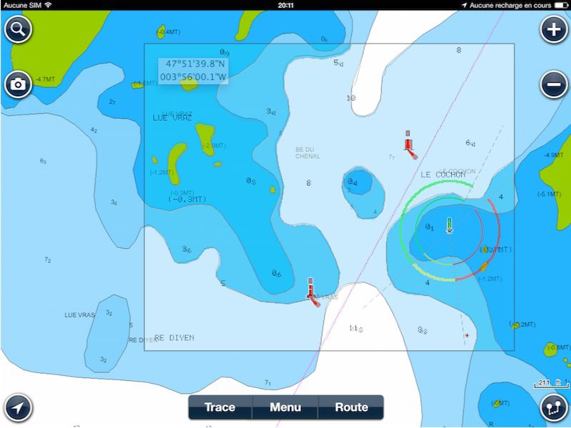
Damned ! It seemed useful to make comparisons closing electronic charts from various sources. As far as I know particularly well geographic location used in example, since it is the approach to the port of Concarneau, near the beacon tower Le Cochon, passage I borrowed hundreds of times over the years I was working with Glenans Nautical Centre.
On port in the channel (entrance) and outside of it approximately 300 meters high, are Lué Vras rocks (or Vraz depending charts). It goes without saying that boats have nothing to do there. But it is a fact that the heights of these drying rocks does not appear on some electronic charts.
Navionics versus Navionics

Heights of Lué Vras rocks are missing on Navionics / x-traverse

Perfect overlay, but the depth contours are better identified with Navionics / x-traverse
Navionics versus MapMedia (TimeZero)
Here we compare the vector charting with raster one. However, must logically find the same location at equivalent scale. In the case below, MapMedia chart is strictly reproduction of the raster chart from SHOM.

Heights of Lué Vras are existing on MapMedia chart


The coverage is almost perfect
Actually, the overlay of the two charts is almost perfect, aligning markup location as a reference. However, there is a slight shift to the right,
Navionics vs. CMap

We can already see that the probes carried on CMap are very approximate

 Once aligned beacons, there is a slight shift of Lué Vras rocks eastward. Globally, except depths, charting is faithful.
What can we conclude ?
Which is reassuring, is that the charts topography, namely the geographical elements positioning, is respected by all publishers. Reproduction of official charts correctly georeferenced. Which is damaging, on the other hand, it is the lack of precision in the reproduction of information. Red Card to CMap, Yellow Card to Navionics cartography delivered via X-Traverse. Concerning MaxSea MapMedia chart, it uses SHOM chart duplication and therefore has no merit.
About the above issue on the forum HEO, the answer was provided to our friend Jean Debèze (¹) by X-Traverse support :
“This is clearly a limitation of the Navionics 46XG cards resold by X-Traverse compared to the Navionics Silver cards incorporated in the plotters. I will ask Navionics to review this in their cartography department and see if additional data can eventually be put into this region of 46XG. Sorry I have no immediate solution, the data provided to us is that which we are able to offer for download. ”
However, should minimize such a gap. The area concerned is far outside the navigation channels, and if knowing the elevation of these rocks can be useful to evaluate a glance the level of the tide passing Le Cochon, this does not create a risk for navigation. Therefore let's be moderate in our comments about. Navionics is by far the most accurate charing and better updated around the World (²), and inaccuracies encountered by boaters can be reported, with screenshots and supporting photos, until dedicated service by Navionics.
I want to say to the readers that I have no particular interest in extolling the virtues of this charting, this is only the observation made during personal navigations, or reported by reliable sources, in many areas of the Globe.
—
(¹) Installing an iMux aboard "Lady Jane"
(²) Charting compared, a mixed result
—
Thank you Francis for this quick response , I would like to take this opportunity to offer you all my best wishes and congratulate you on the work carried out., thanks to you I was able to download and use inavx on my iPad your explanations are perfectly clear ! Thanks for everything, il me reste à charger navionics sur mon iPhone…
Bonjour
Désolé d’intervenir sur ce post mais j’ai la même question que Steph mais avec iPhone :
J’utilise inavx sur mon ipad mais je veux charger navionics sur mon iPhone en GPS portable de secours.
Si je prends Navionics Hd Europe sur mon ipad a 59€ (au cas ou invax plante) sera-t-il utilisable sur mon iPhone ou je dois télécharger Navionics Europe sur iPhone uniquement (39€) pour l’avoir ?
Même réponse. La version iPhone peut fonctionner sur iPad (en taille réduite) mais l’inverse n’est pas possible. Ce sont deux applications différentes.
Merci beaucoup pour l’article.
Je pousse le bouchon un petit peu plus loin 😉 :
Pour les personnes ayant un iPad et un smatphone android , is it possible to pay Navionics only once and the application can be used on both devices ?
Thank you Francis for this once again comprehensive article.. And since you cite my comment on HEO on the problem you will also have noted the one which confirms that although different on the two Navionics maps it is not dangerous. In fact, we agree that access to the channel does not encourage hanging around so close to the rocks in question..
I would like to take this opportunity to send you all my best wishes for the year. 2014 which begins.
Cdt
Bruno