![]() The Pacific Ocean is switching from an El Niño event at the beginning of the year 2024 to a La Niña event expected at the end of this summer. But it seems, for NOAA scientists, that a similar phenomenon is also occurring at this same time in the Atlantic Ocean (¹). Read more …
The Pacific Ocean is switching from an El Niño event at the beginning of the year 2024 to a La Niña event expected at the end of this summer. But it seems, for NOAA scientists, that a similar phenomenon is also occurring at this same time in the Atlantic Ocean (¹). Read more …
Category : Tutorials
How to…
After El Niño 2023 here is La Niña 2024
The climatic phenomenon ENSO (El Niño Southern Oscillation) had experienced a new episode El Niño towards the end of spring 2023 in the tropical regions of the Pacific (¹). After reaching a peak between November and December 2023, the phenomenon began to decrease (²). During the second quarter 2024 he returned to a situation called " Neutral ”. But quickly from July a new episode La Niña started, whose climatic consequences are the opposite of the previous episode.
Source : NOAA Climate / ENSO Blog Read more …
Currents and waves at hectometric resolution from Ifremer (Episode 2)
Episode 2 – Illustrations
Forecasts IFREMER (see Episode 1) available in Weather4D are of two kinds :
-
- Current forecasts from the MARS2D model
- Sea state forecasts (combined currents and waves) based on WW3 model
These files concern areas of the Channel and Atlantic whose coverage and resolutions are significantly different. Read more …
Currents and waves at hectometric resolution from Ifremer (Episode 1)
Episode 1 – Description
Since 7 May 2024 the latest versions of Weather4D have been enriched with several new weather and ocean models (¹). Among the latter, ultra-high resolution current and wave forecast models from’Ifremer come in addition to Copernicus models (formerly called MyOcean) for the Channel and Atlantic coasts. These forecasts are provided with hectometric grids, can be reduced up to 190 meters for some models. So Ifremer, what is ? Read more …
GRIB files and time zones
 An incomprehensible malfunction occurred recently for a Weather4D user, sailing in a “lost hole” on the edge of the Indian Ocean, namely the Cocos Islands, challenged me to the point of getting lost in conjectures. A GFS file due ten days ago categorically refused to be displayed in the application with the date, damn !
This unfortunate sailor - for which I would like to thank him - forced me to make a determined search for the cause of the problem.. After much procrastination, explorations of settings that may be faulty, since no other user had reported such a problem to us, the light finally came out ! Read more …
Update Weather4D R&N 2.0.92 -New charts update
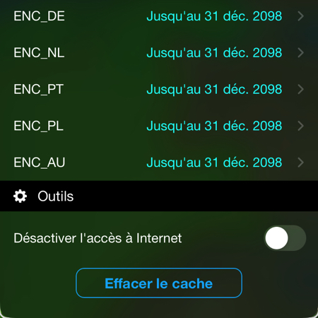 As part of the gradual conversion of raster charts to vector charts ENC (¹) on the platform Geogarage, Weather4D Routage & Navigation now includes the following ENC catalogs :
- Portugal (derived from the productions of the Portuguese Hydrographic Service – IH)
- Poland (derived from the productions of the Polish Hydrographic Service – HOPN)
- Australia (derived from the productions of the Australian Hydrographic Service – AHO)
These ENC catalogs are added to the previous ones already available (Spain, Croatia, Germany, Netherland). Others are under negotiation such as Greece and Sweden.
–––
(¹) Geogarage to introduce ENC charts for Weather4D
–––
Major update to Weather4D manuals
 To follow up on complete renewal of weather and ocean forecasting models in the latest version of the three Weather4D applications (Lite, Routing, Routing & Navigation) the revised English and French User Guides are now available to download. Read more …
Weather4D renews its GRIB model offering
![]() Latest releases Lite, Routing, Routing & Navigation arrive with a full renewed list of weather and ocean models in order to allow users to benefit from the evolution of the offer of international forecasting models. At the same time, all GRIB files go to format GRIB-2, this allows for a reduction in their size and a better compression ratio. Read more …
Latest releases Lite, Routing, Routing & Navigation arrive with a full renewed list of weather and ocean models in order to allow users to benefit from the evolution of the offer of international forecasting models. At the same time, all GRIB files go to format GRIB-2, this allows for a reduction in their size and a better compression ratio. Read more …
El Niño weakening in the Pacific
![]() Following the prediction of an episode El Niño started in March 2023 (¹) and confirmed the following June (²), this climatic phenomenon of the Pacific Ocean, called ENSO (El Niño Southern Oscillation), strengthened until the end of December, early January 2024.
Following the prediction of an episode El Niño started in March 2023 (¹) and confirmed the following June (²), this climatic phenomenon of the Pacific Ocean, called ENSO (El Niño Southern Oscillation), strengthened until the end of December, early January 2024.
The February ENSO forecast developed by the U.S. Climate Prediction Center predicts that we are on the eve of an episode La Niña, even though the Pacific Ocean is still affected by the El Niño episode. According to the forecast, there is 79 % chance that El Niño will become neutral by April-June, and 55 % chance that the Pacific will return to ENSO La Niña between June and August.
Weather4D R&N and distance calculations
![]() Since the arrival of ARM-based Mac (M1… M3…) and the system macOS 11 Big Sur, Weather4D Routage & Navigation works natively on our favorite computers (¹). But this happy event did not go, since then, without some small restrictions. The most annoying for users was, until this day, loss of distance calculation. This is carried out on touch devices by a two-finger long press, no function allowed the translation of this gesture on Mac. The mouse only has one pointer, not two ! Read more …
Since the arrival of ARM-based Mac (M1… M3…) and the system macOS 11 Big Sur, Weather4D Routage & Navigation works natively on our favorite computers (¹). But this happy event did not go, since then, without some small restrictions. The most annoying for users was, until this day, loss of distance calculation. This is carried out on touch devices by a two-finger long press, no function allowed the translation of this gesture on Mac. The mouse only has one pointer, not two ! Read more …