

With the progressive generalization of the AIS (transceivers) on board our yachts (¹), and their mandatory presence aboard a large part of merchant ships, capacities for display and processing of targets (surrounding vessels equipped with a transceiver) have significantly improved our security. Still need to know how to interpret this information that, in high-traffic areas, can quickly become a real headache.
In such a situation, better have a quick diagnosis of the risk of collision ! (Weather4D 2.0)
Best navigation applications, as the screens dedicated to AIS, are able to provide, the display and the progress of the targets, but also the detailed information issued by them, and especially the data calculated in real time on the crossing with these targets and risk of collision.

A drop-down window allows to read all data related to a particular target. Here in night view.
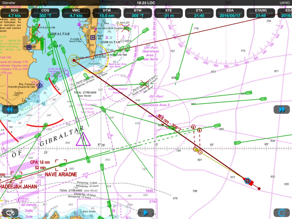
From the route (COG) and speed (SOG) on the ground of a target, combined with the same data of our own ship, the real time calculation allows to provide three essential information : CPA, TCPA and BCPA.
- CPA : Closest Point of Approach. Point where will occur the lowest distance of approach of a target, in other words the point where this vessel would come the more closely.
- TCPA : Time to Closest Point of Approach. The time remaining before reaching the CPA (in hours, minutes).
- BCPA : Bearing of Closest Point of Approach. The bearing of the CPA at the moment where it will happen.
These three information are inseparable. They will allow to anticipate events and modify if necessary our route to avoid any risk of collision, and also avoid cutting too close the way of a larger vessel less maneuvering.
 In the example above, the route of our boat will cross that of the target ship, 'Carmen Bandeira'. The respective velocity vectors are proportional to the speed over the ground for a specified period, 30 minutes in this example. This already allows a glance to assess the respective speed of both vessels, with the longest vector being the fastest. But this is not enough. The drop-down window enabled on the target confirms its speed and its route, and we informed in real time of its distance (RNG for Range), his bearing (BRG for Bearing), CPA, time remaining (TCPA) and bearing (BCPA) of target at the time of CPA. This information is crucial to know if the target will be behind or ahead, in addition to its distance.
 In the example above, if the target ship was much faster (say 15 knots) BCPA would probably have been of the order of 120°-130° and so the ship would come in front of us, presenting a lower risk. Because of its low speed, We are going to come ahead. Be sure it will cut its route sufficiently far ahead, and check frequently if its speed does not increase suddenly.

Weather4D Routing & Navigation indicates the prediction of positions at the time of the CPA by two circles, taking into account ships GPS antenna location.
With Weather4D R&N above, You can activate multiple targets simultaneously to display the predictions calculated in real-time. See also capture at the beginning of article.
In doubt, It should not hesitate to change his own way early enough, to make clear manoeuvre to the other ship, that also sees us on his own screen. The ship's route change is also generated by AIS transceiver, or calculated by navigation application : ROT data.
- ROT : Rate Of Turn. Ship's gyration rate, in degrees per minute, to port or to starboard.
This data is particularly important for large tonnage ships which manoeuvre changes are very slow and may be imperceptible to the eye. The display on the chart or the screen of the ROT is usually done in the form of an arrow to port or starboard at the end of the velocity vector, in addition to the data displayed .

AIS target information in iSailor
In all software and dedicated screens alarms are adjustable for the CPA, TCPA or simply a minimum distance of targets. But it provides nothing of a careful watch : all ships are not yet equipped with an AIS transceiver, or even sometimes switch it in "silent" mode, i.e. free broadcast reception.
———
(¹) AIS, the second maritime revolution after the GPS
———
Again thank you Francis for the Info. It should still be added as the Strait of Gibraltar, like sleeve, two of the busiest places in the world, have a descending corridor and an amount corridor, We sail right ! And it is forbidden to cut these corridors in bias but only perpendicular that visibly the 2 targets studied (Phaethon and Carmen Bandeira) do not comply with ! Where the interest of the AIS…
The Gibraltar rail begins, in the East of the Strait of Gibraltar, to the longitude of Algeciras. Example ships are en route from free navigation. In my examples the "Phaethon" is heading to be placed in the outgoing rail, the "Carmen Bandeira" has long since left the incoming rail, just like our own boat.
Hello,
Good article, with just two remarks retail : AIS transceivers are not the tanspondeurs, to the extent that they emit at a rate defined by their class without interrogation, as the aircraft transponders are (Military IFF, civilian secondary radar) or the SART radar. The corresponding word in English is the neologism "transceiver" and not "transponder".
The TCPA is the time remaining until passage CPA, as you say very well, and should therefore be defined in English as "time to CPA".
It would probably be useful to clarify for boaters that calculated CPA is often variable due to the variations in road and speed due to the sea, the wind and the quality of the coxswain of our small units, as well as the sometimes poor quality of the reference in Cape, This is also valid for the use of ARPA or mini ARPA on Marina radars.
Good to you
The term "transponder" may be technically incorrect., However it is used in french by a majority of manufacturers, reason why I picked it up. For the rest I perfectly agree with you.