
Less than a month before the launch by Ariane 5 of four new satellites carrying the GALILEO constellation to 18 satellites, manufacturers of tracking components have already presented their new tracking chips supporting European GNSS. This allowed the Spanish company BQ to offer the first “Galileo-ready” smartphone at the beginning of September., equipped with processor Qualcomm Snapdragon 652, l’Aquarius X5 Plus.
We might have expected to find the same chip in the iPhone 7 from Apple, which has since fitted the iPhone 4S and the iPad 3 all of its mobile devices with Qualcomm communications processors, integrating GPS reception (US) and GLONASS (Russian), it's nothing. With this latest smartphone, Apple reconnects with Broadcom, sidelined since 2012 to perform these functions, by integrating a chip BCM47734.
Broadcom comes back on board
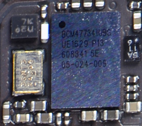 In the iPhone localization specifications 7 Apple only mentions GPS and GLONASS. The moment of disappointment is over, we can wonder about this – mysterious – BCM chip47734, which seems specific to the iPhone 7. Indeed, on his website (¹), Broadcom presents the BCM chip4774, successor to the BCM4773 :
The BCM4774 Sensor Hub chip integrates a GNSS receiver with second-generation sensor hub functionality on a single chip. It simultaneously supports Galileo, GPS, GLONASS, SBAS, QZSS and Beidou […]
– Support for the European Galileo satellite system combined with simultaneous support for six different satellite systems.
– Until 95 percent energy savings compared to standard GNSS receivers and Sensor Hub systems.
– 30 percent reduction in map area by integrating the GNSS receiver and sensor hub.
– Hardware optimizations further increase energy savings
– On-chip Wi-Fi positioning using a communications protocol by direct connection to the Broadcom connectivity combo chip family.
However Apple announced that the A10 processor includes its own sensor hub (Sensor Hub), so that if the BCM47734 also has a sensor hub, we can assume that it is disabled, or simply unused, in the iPhone 7.
Would it be reasonable to think that GALILEO support could be activated by an update of the iOS system? ? Or does Apple consider this feature to be premature?, and reserved for a future successor to the iPhone 7, or a future iPad ? The question remains unanswered to date..
GALILEO is tomorrow
With 18 Initial satellite services are expected to be open before the end of this year (²) :
- Search and Rescue (SAR) System integration Medium Earth Orbit Search and Rescue (MEOSAR) key contributor to the COSPAT-SARSAT international search and rescue service.
- Public Regulated Service (PRS) Encrypted signals for restricted use intended for strategic industries and public service missions. Reliable and secure thanks to anti-jamming mechanisms and anomaly detection systems.
- Open Service (OS) Free and open-access service, intended for the general public, offering positioning accuracy to the meter. This service will concern car navigation, land and sea, and positioning on mobile devices (smartphones, tablets, aso).
The complete constellation before end 2020 will provide commercial subscription services which should constitute the bulk of the system’s resources.
GALILEO today
Satellites currently in service, operational or in testing phase, are now visible to receivers. Satellites marked “F” in the table below are already transmitting valid navigation signals.

L’application pour iPhone GNSS View allows you to see in real time the constellations of all the networks sending a signal, dont GALILEO, together or separately. We also see the SBAS (³).

It would be a shame to have to wait for a possible iPhone 7S or iPad Pro 2 within a year to use the European network. Remember that there was a time, fortunately gone, where the American administration had put many obstacles in the way of the GALILEO project.
———
(¹) Galileo, the point of view of a chip manufacturer
(²) Source : EUSPA
(³) SBAS = Satellite Based Augmentation System. See Glossary.
———
Bonjour,
Thank you for these details on Gallileo, which we will have on our future tablets.
For the use of a ready meter stitch ( see in cm ) we must not forget that we with our boats are not the marketing target targeted by all these constellations of satellites. Cars without drivers, drone deliveries and other new services need this precision. The gnss of our cars do not know if we are on the left or right lane of the highway or worse on the parallel national road, the embedded software positions us on the right because it knows that we are in France, not with our English friends.
1 precision meter in GPS positioning, it is super. You still have to be able to take advantage of it. Let's not forget that most nautical charts are referenced to the WGS84 geosphere, and that these maps were collected well before the appearance of GPS. These maps have therefore been retouched to “correspond” to the WGS84 geosphere. On a map 1/40000, the geographer must draw his line with a positioning precision of +/-1mm. 1mm to scale 1/40000, it is 40 meters high…
For the anchor alarm, I can understand at a pinch the need for 1 precision meter, but for the use of cartography, it's completely useless.
I completely agree with your point of view. ! See ENCs, Routing and sailing shaves stone
Thank you for this very useful technological watch.