Since the start of the navigation season, many boaters have found an increasing number of errors on Navionics charts, following recent updates, all media. All over Europe, Germany, Baltic States, French coasts of the Channel and until Spain, appeared non-existent channels and erroneous soundings, missing soundings, Missing information, Conflicting bathymetric information depending on zoom levels, and so on. Most importantly, these findings are made by long-time regular users of Navionics charting, experienced sailors.
[Corrective update 26 August 2015]
[October Corrigendum Update 2 2015] See end of entry.
The first to inform me of this was Jochen Lührs, iNavX's German translator, with whom I recently collaborated in the writing of iNavX tutorial in this language. He sent Navionics support a documented email with screenshots of the many defects observed during his summer sailings. At the same time, Several threads on the subject have been developed on the French forum Hisse-et-Ho Where the revolt is organized. Some contributors to this forum have also sent to the help@navionics.com Their findings. This forum is public, I extract some revealing quotes from it, the authors will recognize themselves :
" Back from Holland, I noticed many differences between actual soundings (corrected potential gap of tides) and the sounder's values. Back in France, I am surprised to find out about new versions of the Navionics charts a channel around the island of Tatihou close to St-Vaast-la-Hougue. ”
" I did more than a few years ago 6 months attempting to report to Navionics that many soundings contours in the small port of Burela in Galicia were completely crazy over the official charts and all other electronic charts soundings. ”
" […] by comparing, about Perros-Guirec, Navionics SonarChart updated a few days ago with the ordinary Navionics chart : Martian canals spring up on the foreshore in front of the port, and, Oh surprise, There are now two benches which discover before two pontoons, including mine (For those who don't know : the underwater quay that surrounds the port provides at least 2,5 m water […] everywhere). ”
SO, what happens to Navionics ? I have promoted this charting, mainly for iNavX, I have it widely used and considered so far as being certainly the better designed and better update of private vector charts. Unfortunately, marketing orientation of Navionics to risky choices confirm the fears I expressed five years ago (¹). The recent deterioration of charting quality is undoubtedly the consequence.
SonarCharts and Community Sharing
 The concern to maintain the Navionics Boating application (ex-Navionics Marine) at the forefront of mobile navigation apps has generated the bright idea of offering users to power, by their own identified of soundings, bathymetric charts called SonarChart. These charts with the sole purpose to improve the marine recreational fisheries ground contours. Navionics has developed support of different sounders among the most used by boaters. The data collected in real time during journeys is supposed to feed a community database for this purpose.
However, it seems that the reality is a little different, and that SonarChart have only actually collected interpolated details. Moreover, what credibility should be given to the data collected by amateur sailors ? As these Internet users express :
" I find it absolutely implausible, even criminal, Navionics alters its charts […] using soundings provided by users who are not really able to give absolutely accurate information. ”
" When we know how seriously the hydrographic survey by official services are performed (even if they are old) One can be stunned by the fact that an ordinary boater, often unable to do a calculation of tide with twelfths rule, can transmit information affecting the safety of the ships to a provider of electronic charts. ”
I agree with these remarks all the more because I have already expressed myself in this direction in the past (¹). But that's not the worst.
Navionics nautical charts and SonarCharts
In Navionics Boating app, you can switch between the 'nautical' so-called chart and SonarChart. The first being to navigation use and the second to fishing use. This is what Navionics' customer service expresses to a user in response to an error report, I quote :
" […] We also remind you that the layer Sonarchart is not suitable for a safe navigation, it is useful for locating fishing areas at any depth level. While navigating, make sure you have activated the nautical charts.
Navionics Customer Service".
Surprising response regard to maritime safety. Even more surprising than the recent updates of the Navionics charts (all media) provide many mistakes that seem directly from data displayed in the SonarChart, unable to correct in iNavX or in a chartplotter because they have no alternative to display.
Below the two versions of the same chart in Boating HD, But there seems to be a reversal. The chart on the right should be the Navionics "navigation", and I hope that the absence of soundings has been corrected subsequently (I have not subscribed to Navionics+).

Navionics Chart (navigation) Left, SonarChart on the right. Charts appear reversed. I have soundigs at left, not at right. This is not the latest update, however.
Left, The two channels in blue do not exist and present a risk of grounding. This area is covered with oyster beds, only motorboats pass on above mid-tide. Found the same chart in the last Navionics Gold 46XG for iNavX update (from the X-Traverse server) :

Left non-existing channels issued from SonarChart in iNavX. Right the most recent raster chart NV Chart from SHOM
Another example in Perros-Guirec, two successive updates with appearance of "Martian canals". (See above) mentioned by a contributor. It is understood that these channels are totally far-fetched.

Two successive versions of SonarChart. More and more misinformation.
Below, the Navionics "navigation" version (Correct) compared to the raster NV Chart issued from SHOM. Found but minor details the same Navionics chart in iNavX (Indeed the alignment of the two leading lights at 224° is not drawn).
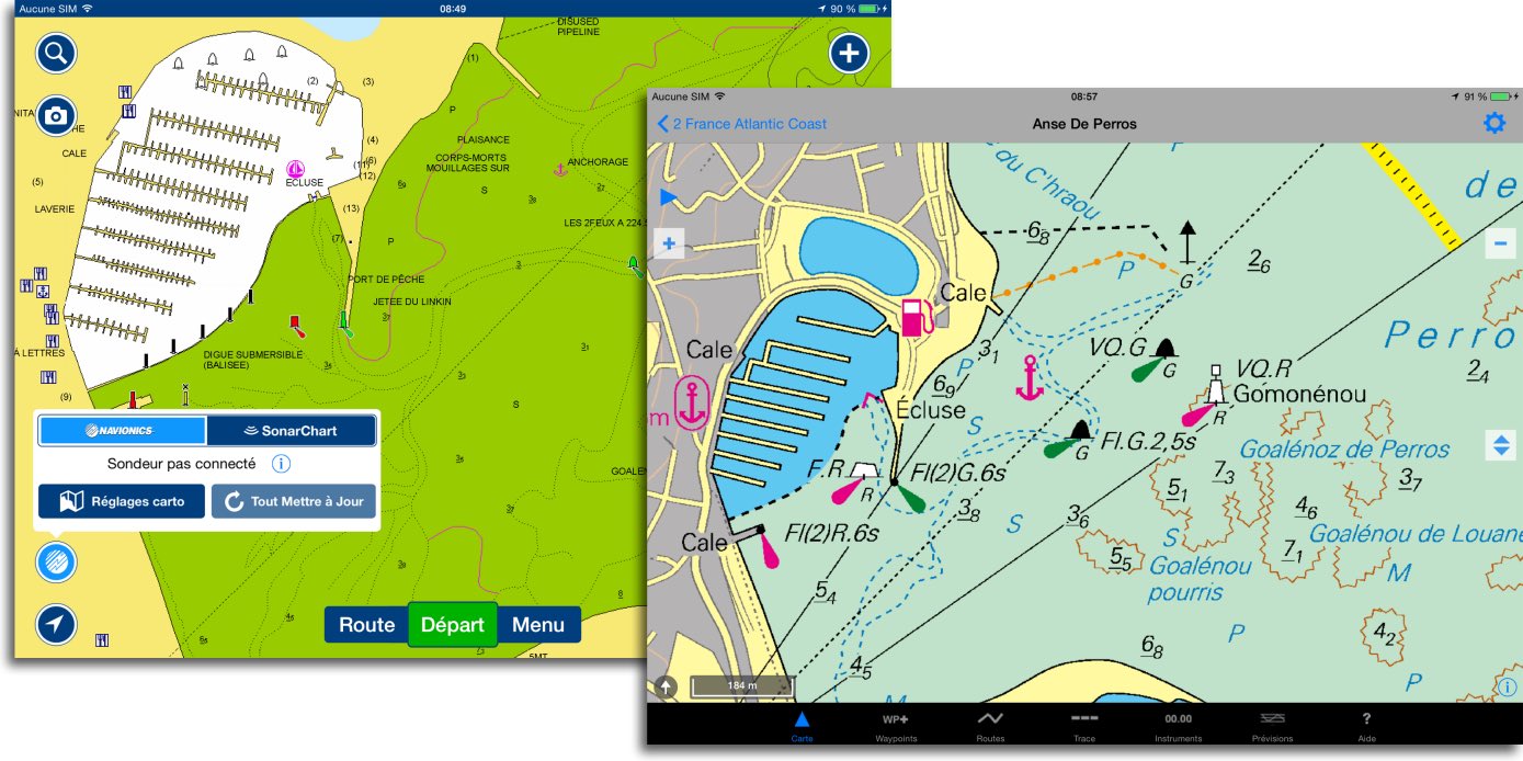
The map on the left in Boating HD by selecting "Navionics" has not been changed and looks correct.
Public or private charts ?
If Navionics does not quickly become aware of the rapid degradation of its products, It is likely that boaters will turn to other more secured solutions. With the rapid advent of’Open Data' within European administrations, boaters will certainly access public charting at lower costs, or even free soon. Today, It is already possible to use in Weather4D Android all SHOM electronic raster charts catalog (60 €/year) , UKHO, and other official publishers. Soon it will be available in a future iOS version. The SEAiq application also allows to use the official vector charting ENC S-57.
Private vector solutions (Transas TX-97, Navionics charts, BlueChart, C-Map charts, aso.) should a sacred level of excellence to maintain their economic model the day that European hydrographic services will be free as those from NOAA. Also in order to face the outsiders who have been appearing on the market for some time (²). And it is certainly not a random bathymetry that will make the difference, We will have to put a little more seriousness and professionalism into it.
[Corrective update 26 August 2015]
The Navionics 46XG update dated the 26 August 2015, available for iNavX on the website X-Traverse.com, has made the disputed "Martian channels" disappear. This update has not yet made an announcement by Fugawi mail as usual when major updates. Thanks to the user who just warned me. No info about the other files.

[Correcting update 17 October 2015]
The latest October Updates removed bathymetric data from SonarCharts from all standard charts. But Navionics is not abandoning the SonarCharts, Major selling point.
___
(¹) Navionics Mobile and Community Sharing
(²) Raster charts... the come back
___
Thank you for your quick response, the problem is that the 46XG is divided into two zones: Bay of Bicay Brittany South and : English Channel Brittany North (W4 and W3, Very recent references) and it was only this morning that the northern part was kind enough to take charge…..
That said, the different odds are still as fancy and I keep an eye on my paper cards .
After an update that erased my cards I bought a new card : 46XG. Unfortunately, the cover is no longer the same : I lost the south of the British Isles and the east of the north coast of Brittany (nothing left east of Perros-Guirec) . I wanted to top up another card (still under 46XG but renamed "English Channel and North Brittany" : impossible even if you pay, I don't understand !
On the other hand, by comparing with the paper maps I notice many approximations and very fanciful dimensions, particularly around Sein…..
The 46XG region always contains the same zones, there has been no change. If you have any missing areas, without the details, it's just that you haven't downloaded them completely. In doubt, download the entire 46XG file. Read this tutorial again :
How to update charts with iNavX
Thank you for this corrected post that allowed me to reload the patches applied by Navionics before the end of my subscription in 5 days.
In this regard, I sincerely wonder if we should continue to sponsor this company.
W4D should soon see the light of day on IOS with a serious official mapping. Isn't that what we're going to have to turn to quickly ?
I only regret that the loaded maps are apparently cached and not reside on the Ipads.
It would still be safer to make sure you don't lose anything, knowing that you don't always have quality internet on board to reload the necessary maps.
To be continued.
For now I am suspending my regular subscriptions to Navionics via x-traverse and I will let the shows know on the Navionics booth. If there are many of us around the world who do the same, perhaps they will end up reviewing their marketing models.
We can always dream.
Cdt
Bonjour. I end up not understanding anything about this case.
Know when these "channels" were added to the inavx cards without our knowledge ? Is it only a few weeks before summer, or several months, or even years before ?
Because I did my last update on Xtraverse at the beginning of April, and the map of the Glénan was good, without that famous blue passage between the Chamber and the Magpie. So I'm happy with my version.
My dilemma : Was my version loaded at the beginning of April made before the mass integration of imaginary channels? (it is therefore healthy) or does it contain any that I do not know ? (she's rotten)
True to the old adage, We don't change what works, I'm hesitant to update it.
There were updates in June and at the end of July, SonarChart inputs were incorporated at this time. You will receive an email from the company Fugawi for each updated file.
The latest update to the 46XG map removed the wacky data from SonarChart, You can update.
Bonjour,
I must moderate my previous remarks, because Navionics engineers have heard users' requests about tide times and water levels. In the Beta versions for android and iOS that I am testing, everything is good. In addition, the correction of water levels will be done on the user's smartphone/tablet and no longer on Navionics' central servers.
NOTE: Navionics charts are not certified for navigation without paper charts. The use of their Sonarchart charts is not recommended for navigation.
Only government maps without private modification are so as the SHOM maps in France, with of course an annual price much higher than the cost of a Europe card at Navionics.
No private electronic cards (Private ENC), from any publisher, is certified for navigation. Only the official ENC S-57/S-63 cards are. This is a purely legal argument that should in no way absolve publishers of the professional moral responsibility. The vast majority of mariners use electronic charts exclusively, on specialized readers as well as on computers, by trusting in the quality of the products. If doubt sets in, Trust will be lost and users will inevitably turn to official maps and abandon private publishers.
To date, the Navionics charts on the X-Traverse site have not yet been corrected from the numerous and dangerous errors noted.
Bonjour,
Back from holiday in Northern Brittany after updating the map at the end of June, I realize that the few aberrations of the maps observed are produced by an implausible and dangerous program.
I add to the list already mentioned, the crazy canals of Ploumanach and the old port of Roscoff.
But for Roscoff, The correction is made on the map linked above.
What does this mean, probably, which they correct as and when complaints are made.
Super professional approach.
It seems to me that we would be entitled to demand that the maps be updated free of charge, after complete rectification.
Not to mention the’ assurance that this unrealistic program is definitively forgotten.
It is indeed chilling and hurting the wallet when you know the price of these products.
What seems absurd to me is that the cartography, Mandatory safety feature on board a ship, is not governed by standards (THAT, ISO …) The compulsory vest meets a standard, but not the map. This is not normal.
Hello Francis, Thank you for this synthesis of our heated discussions at https://www.hisse-et-oh.com/
To see the latest updates to Navionics charts, No need for a smartphone with subscription, or to update your maps on the medium. Indeed, there is only one source of Navionics charts, which is visible on their website. Maps on other media or software are derived from it.
Look for example at Saint Vaast la Hougue with the modified navigation map and the sonarchart map still in error (Click on the blue button at the bottom left)
After having studied the entrances to ports and rivers from Dunkirk to Rochefort, I find 80% of false cards, especially for areas with tidal times and heights disturbed by local effects: bay of Mont Saint Michel for example. Watch the entrance to Granville in sonarchart, The navigation chart returned to normal today 24 August 2015. The same goes for Roscoff.
Then as a user of a probe connected via WiFi to my smartphone, I checked the tidal height corrections applied by the Navionics mainframe computer to my readings with the sonarchart live function.
Navionics has developed its own triangulation tidal calculator (The classic 3 points) and lead to beginner's mistakes in mathematics and hydraulics.
Hence all these errors in the calculation of probes leading to these blue channels.
For me, It is criminal to propagate these uncontrolled probes to the navigation chart
Courtox
Same for me. Wanting to show the cards (on Lake Geneva) To a friend who wanted to buy Navionics, I noticed inconsistent discontinuities among the respondents, of astounding water heights. Navionics has reached its limits, Long live paper
I have made the same observation several times.
Before leaving I bought the Navionics chart update for our Raymarine plotter.
The most important error was found in the port of Cedeira in Galicia.