I relayed in December 2018 an excellent issue published on the blog of our friends at Geogarage, who make a permanent duty of a press review of the best foreign articles concerning cartography, meteorology, and more generally all subjects related to maritime navigation. Here is a translation freely adapted and commented on in French.
The new American weather model shone during Hurricane Lane
It is well established that the European Meteorological Model IFS (¹) the European Center for Medium-Range Weather Forecasts (²), produces on average the most accurate weather forecasts in the world. For years, the American Global Forecasting System model (GFS), managed by NOAA's National Weather Service (³) , only placed third.
The "bad student" rank of the American GFS model has attracted the attention of Congress, which has appropriated money to the Weather Service to improve USA’s weather modeling on multiple occasions. Already, after Hurricane "Sandy" in 2012, whose final trajectory upon New York had been only anticipated by the European model, the U.S. Congress had, by an additional budget, enabled the NWS to make big progress with successful start to the GFS redesign early 2015 (⁴).
In addition, The U.S. administration has stated that building the best prediction model in the world is a “top priority.”.
The future GFS-FV3 forecasting model
A new analysis of the model's performance during Hurricane Lane, which unloaded historic amounts of rain on Hawaii’s Big Island, shows that the Weather Service may be making progress.
The NWS has developed a new version of the GFS, known as FV3 (Finished Volume Cubed-Sphere dynamical core), which it touts as “its next-generation global prediction system”. While still considered experimental, the FV3 produced the most consistently accurate predictions of Lane's track. The NWS claimed :
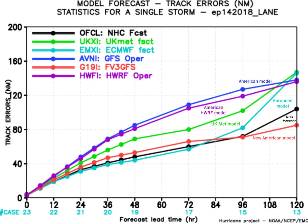
"We got a table from the weather service showing the tracking errors for each of the models at different times. Track errors tend to be large for forecasts of the storm’s position several days into the future, but they diminish over time. ”
- The FV3 produced the most accurate forecasts (or the smallest trajectory errors) made between four (96 hours steps) and five (120 hours steps) days into the future. It was neck and neck with the predictions of the European model and the National Hurricane Center in the 72 First hours.
- The European ECMWF model had large errors in its four- and five-day forecasts, but he has shown the talent for which he is known to be less than 72 hours steps (3 days).
- The British MET model, which is the second most accurate model in the world, managed by the UK Met Office in Exeter, lagged behind the performance of European model forecasts, Hurricane Center and FV3 at all times.
- The current operational version of the US model GFS practically had the worst prediction of performance at every step.
- The American HWRF model, which is a specialized model for hurricanes, also performed poorly, Ranking second to last. Some of its input data comes from the GFS, Which explains why both models had comparatively poor performance.
Although the FV3’s results were very promising for Hurricane Lane, they reflect just one very limited case. To be convinced that this new modelling system could reduce the gap with the European model, we will need to see such performance repeated, storm after storm and in everyday weather situations, from the tropics to the poles.
[Update 12 June 2019] This Wednesday 12 June, the GFS model-FV3 has just been Announced as operational.
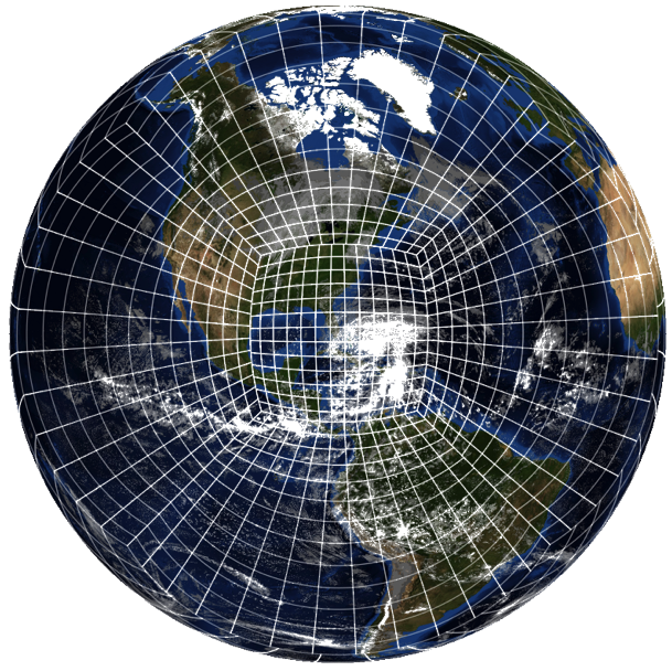
The FV3 dynamical core divides the atmosphere into small cubes arranged on a grid and computes the changes in winds and pressure within each cube as part of a model's forecast. Models using the FV3 have the capability to zoom in on storm systems to improve predictions. Here, we see a satellite image of Hurricane Sandy with a stretched version of FV3's cubed sphere grid, zoomed in on the hurricane.
–––
(¹) Integrated Forecast System, commonly referred to as CEP
(²) In English : European Center for Medium-Range Weather Forecast (ECMWF)
(³) U.S. National Oceanic and Atmospheric Administration
(⁴) New GFS grid 0.25° model
–––


Bonjour,
This seems to be great news if we look at the isolated cases of this study, but are there any similar studies (but more statistics for the time being) on a larger number of comparisons and on more used parameters (at least in navigation) such as wind strength and direction at a given point in time?
Sincerely
Re: [Update 12 June, 2019]
Do I understand it correctly that from now on when I download grib data based on GFS (in Weather4D 2.0 and others) it is effectively FV3 data? Or will apps will be updated upon.
Yes, GFS is now updated with FV3 core from yesterday 06Z in Weather4D (all versions).
It must be recognized that in the Mediterranean the GFS are being smashed by the WRF. Unfortunately in Thailand where I am sailing at the moment I don't know if and where the WRF are available!
Thank you for this very enriching article! Cdlt