
As discussed in the GPSNavX and MacENC help pages, under the “Simulator” section, you can use the function Simulator to carry out dead reckoning navigation. The simulator, Indeed, can be practical in the case where we do not have – or more – a connected GPS.
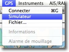
The simulator launches from the GPS menu
 The simulator uses the last known GPS position to position the vessel. However, an input pane open under the "GPS" window allows you to enter a starting position in latitude/longitude, or use a waypoint as a starting point by selecting it from the "Move to" drop-down window.

Input pane
Implementation

Seize the course
Speed and heading can also be entered. For the course, A dial is used to display the value : if you place the mouse cursor directly on the wheel to rotate it, You can only select an approximate value. If you point to the dial, Holding the left button moves the mouse cursor away from the wheel, the further away you go, the more you can choose a precise heading value (as if you were acting on a winch crank).
Of course, You must display a heading that takes into account the estimated drift of your boat : drift to wind and/or drift to current, as you would do by plotting the estimate on a paper map.
Once the simulator is in action, all navigation functions are also active, as with a connected GPS : Waypoints and routes, GoTo Function, Arrival Alarm, aso. For example, in the "Map Settings" window, "Waypoint" tab, You get all the information regarding your approach to the Waypoint.

Exemple de navigation à l'estime simulée
Note :
1 – The simulator does not automatically select airspeed and heading, even if the data comes from the instruments.
2 – The speed must be greater than 0,4 knots to be able to choose a heading.
Hello,
How to get this basemap (or the 9999!) To finish preparing the license with the Mac in addition to the paper card….
By checking your email inbox.
Thank you
JM PONCET
First of all, thank you for your valuable help in discovering and using MacENC and other software. For my part, having been trained in CNG, there are more than 35 years old, to navigation, to esteem, I came to MacENC only out of curiosity. I have acquired the rights to use it, I struggled a little with the GPS antenna, but I'm a little reluctant to buy vector charts from Navionics whose cost is not neutral. I sail in Southern Brittany and will continue to do so in high esteem with, for safety, a GPS.
Is there a cheaper solution to acquire a vector map of Southern Brittany??
Merci
JM PONCET
For a small area like Southern Brittany, we have to see if the official S-57 ENC cards would not do the trick, because the areas sold are smaller. The links to the dealers are on my website, to the page Vector maps.