![]() Weather4D Routage & Navigation offers a choice of raster charts from many international hydrographic services . Charts folders are available for application on the French web server Geogarage. Charts are subject to an annual subscription by Publisher directly on Geogarage website after creating an account there. After subscribing to a publisher, the entry in Weather4D 2.0 credentials created in Geogarage activate display of subscribed folder , ready to download. Procedure step-by-step :
Weather4D Routage & Navigation offers a choice of raster charts from many international hydrographic services . Charts folders are available for application on the French web server Geogarage. Charts are subject to an annual subscription by Publisher directly on Geogarage website after creating an account there. After subscribing to a publisher, the entry in Weather4D 2.0 credentials created in Geogarage activate display of subscribed folder , ready to download. Procedure step-by-step :
Create Geogarage account
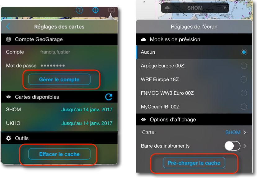
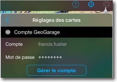
Geogarage can be accessed directly from the application by the "Manage account" button :
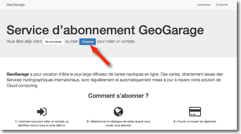 Sign Up is to create account, then to confirm it by clicking on a confirmation link received by email after validation.
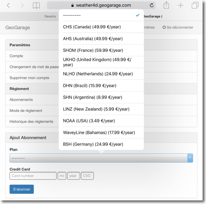
Subscribe to a publisher
Once confirmation completed , The account is accessed with the username and password created, and you select the file you wish to subscribe to in the "Plan" section, then proceed credit card payment.
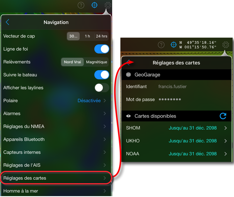
Accessing the Folder in Weather4D Routing & Navigation
After completing the payment, we open Weather4D Routing & Navigation, in Menu General Settings > Navigation > Charts Settings, enter the Geogarage identifiers entered to see the list of the (or more) chart(s) Subscribed(s).
Charts loading is done as "tiles" with display and zoom on a geographical area. Charts will be stored in cache to be used offline at sea. The memory cache of 1 Go is shared between nautical charts, satellite imagery (Bing) and land maps (OSM). It is awarded in a Protected memory area, cannot be deleted only by a user action : exceeding the memory size by loading new tiles or action on "clear cache" button.. The size allows a large number of "tiles" to be loaded with different levels of scale.
One can also pre-load all the tiles in a given area with the pre-load feature :
 The coverage of the entire geogarage portfolio can be consulted by publishers on this page " Coverage ”
See the free iBook tutorial provided with the application (*) for using maps in Weather4D Routing & Navigation.
———
(*) Weather4D 2.0 revisits navigation on iPad [Update]
———


Me again, I'm rereading your blog. Concerning the first question, MacEnc, unless I'm mistaken, it's not via Xtraverse, or not only via Xtraverse, free American Encs via the NOAA website and the others via Primar, Chartworld, ScanNav for example. I am wrong ?
X-traverse for Navionics, but also the ENCs via Chartworld, Primar and others, You're perfectly right.
Bonjour,
Thanks to the developer and the one who promotes it.
Just a quick question about cached maps. What happens if the ipad is turned off? Does this have an influence on the available memory and therefore the performance of the applications?? What if other apps need cache (is it taken by freeing from weather 4D)
Not being a great technician, I apologize for the naïve and/or incongruous questions.
Thank you in advance
No influence on cache memory, Standby or off. Cache assigned only to Weather4D, Not accessible to another application.
Hello again,
I use weather4d pro for routing and then export the optimized route to inavx, Imray.
I'm wondering about the pros/cons of weather 4d v2.0 compared to weather4d pro. Thank you in advance for your comments.
The answer is in my article and in the app's description on AppStore :
– Comprehensive map navigation application combined with weather routing
– Multi-Route Simulation and Routing
– Creation of waypoints and routes on official nautical charts
The options of the old PRO version will be added in future updates : Iridium phone queries, Road transfers and waypoints.
Bonjour,
I bought and installed Weather 4D 2.0, created an account on geogarageweather4d and took the subscriptions for the maps for Argentina and Brazil. Then install the account in Weather 4D. Cards appear in the account view under Card Setting = ok.
In app views, the Argentina card is ok and works very well. But the Brazil map is not. It appears in the possible choices, is selectable, But don't come to the screen. She deeled herself on her own from the closed window.
Can you find out about this point ?
Also, two other questions : What about loading a GRIB by request with an iridium connection ? And what about loading geogorage cards on the high seas or without internet connections = should you have preselected beforehand and on the ground all the desired tiles ?
Thank you in advance for these interesting points those who are too far from the WiFi Point…
For the first question you have to question the developer directly contact@weather4D.com.
For the second, The answer is given in this commentary.
Hello again,
Unless I'm mistaken,, The cards available on geogorage do not cover a large part of the Mediterranean…Could you if it is correct? Thanks in advance!
Indeed the coverage is not yet global. The eastern Mediterranean basin is not covered. This will evolve in the coming months
Bonjour,
If I understood everything, You must perfectly prepare your nav in the wi-fi zone and open all the cards without forgetting the detail cards before you get sea.
Having opened practically all the maps of the French Atlantic Channel Facade, I am amazed by the little memory used ( environ 500 MB ) and the speed of loading ( vs Maxsea )
Tell me if I'm wrong !
In any case thank you and thank you to Mr BOUYSSOU for this wonderful Christmas gift
Bon réveillon
Le cache mémoire est de 2Go. Vous avez donc tout bien compris 🙂
Bonjour et bonnes fêtes! J’ai sur mon iPad weather4d pro, est que on doit acheter la version v2, pour accéder à cette nouvelle fonctionnalité?
Thanks in advance.
Weather4D 2.0 is effectively a new application replacing Weather4D Pro. It is therefore the subject of a new purchase. However, Valid fine-mesh forecast subscriptions can be carried over by simply entering the codes and identifiers created in the old application. See page 15 of the new tutorial.
J’ai raté un épisode ? sur mon iPad je suis en Weather 4D Pro je suis en V1.4.6. La v2 est accessible depuis quand ? sur iPad ?
Effectivement je lai trouvé sur l’App Store, je ne sais pas pourquoi l’appli ne sort pas en premier, c’est pour ça que je ne l’avais pas vue. 50€ on change de catégorie, mais bon c’est une super appli 🙂
I must be very bad because I did not find the link on the geogarage site to register and create an account.
Francis can you put the direct link on the page concerned ?
I looked for here after clicking on the geogage logo of your article (http://www.geogarage.com/fr_FR/)
https://weather4d.geogarage.com/fr/
Oops ! Champagne bubbles should not be completely dissipated this morning, I forgot the principal : the link. Corrected by Olivier and in the article.
What about the access of this mapping by Incax and Mac Enc?
Happy end of the year to you and thank you again all your lessons and information.
No report. The card server for Macen or Incax is exclusively x-traversse.com