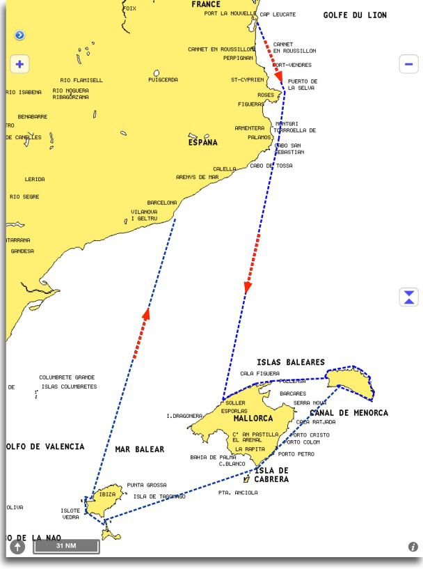
 Three weeks and 600 nautical miles of sailing between the mainland and the Balearic Islands have allowed me to test in live some of iPad maritime applications we have.
Warning : There is no question of making a point-by-point comparison between applications, but rather to highlight certain essential aspects of their use. On the other hand, applications used were up-to-date at the beginning of July. Developments are rapid, and updates may have occurred in August or early September that I did not have. Finally, the messaging app iNavX associated with Navionics charting available from the X-Traverse server for me is the "master-standard" marine applications. iNavX is the most complete application in terms of features to date, and Navionics charting (from the X-Traverse server, I specify) closest to the geographical reality observed by many users.
Designs
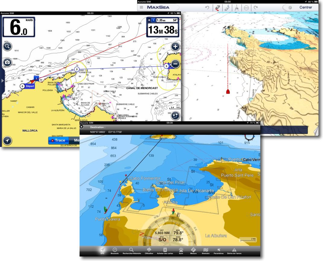
What is most striking when alternating applications on the same route, This is the sometimes fundamental difference in design and ergonomics. At least, applications incorporate three essential features : Create waypoints, create routes of many waypoints, and save the track all along the progress of the boat. They all do that, more or less easily, surely, But they do it. However, two aspects seem fundamental to me to compare : ergonomics, that is to say, the ease of implementation associated with design, and the quality of the proposed charting. you can see below two diametrically opposed designs between Navionics Marine HD and Nobeltec TimeZero :
In both cases the navigation information provided is the same, a retractable drawer to the left in Navionics Marine HD, a semi-transparent panel to drop from the bottom in TimeZero. However the first is frozen, The second is fully configurable. The creation of a route in Navionics Marine is extremely easy. In TimeZero a little less intuitive at the beginning, but once you understand the way to, very simple for use.
Nautical information
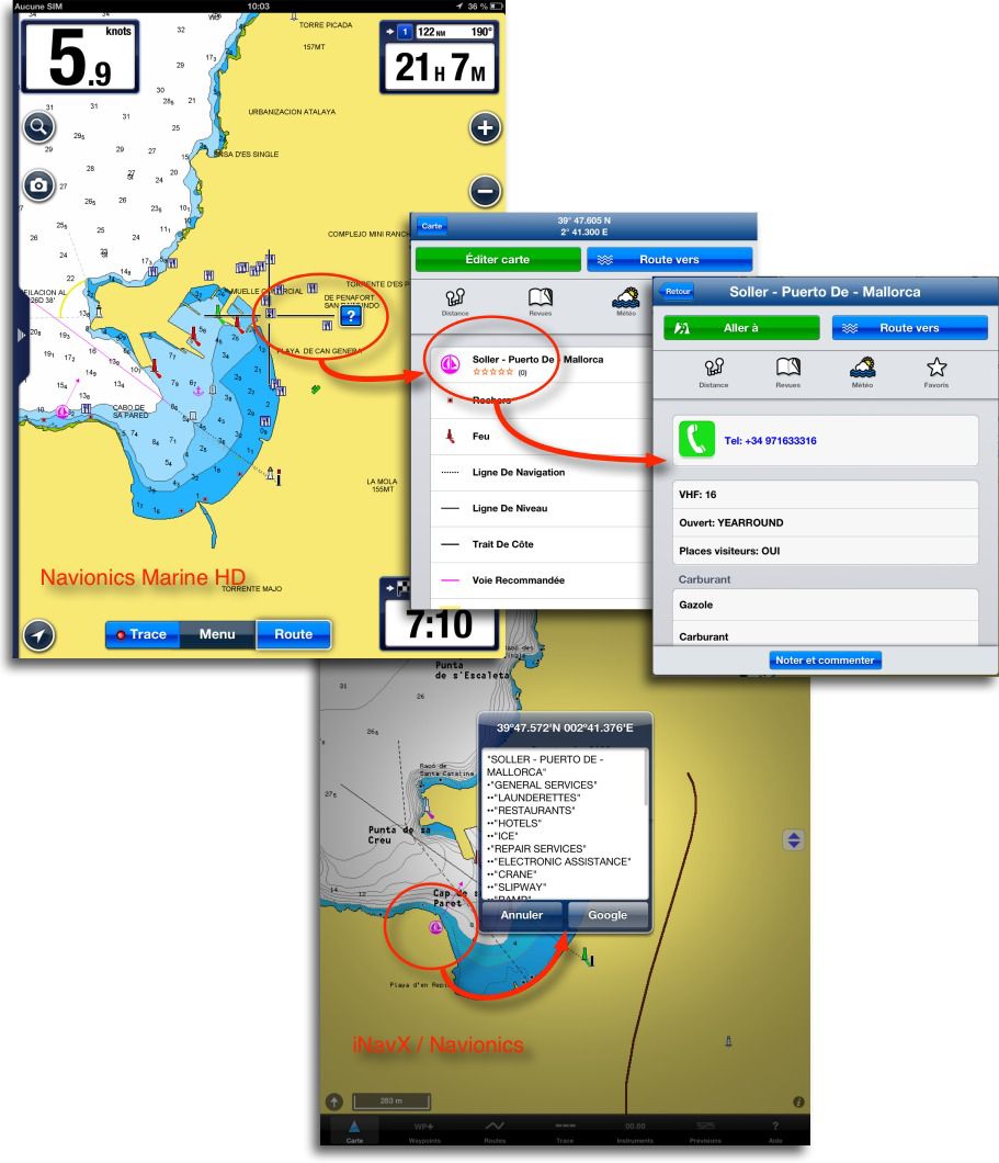
Usually two kinds of information must be provided by applications : the Navaids and the Then. If navaids are generally available in vector charting applications (iNavX, iSailor, Navionics Marine, BlueChart, Plan2Nav) Because extracted from a database associated with marine cards, they simply do not exist with the raster charts, that show only what is printed on the scanned chart. For peas, The palm comes back to Navionics Marine HD and at Plan2Nav (Jeppesen/CMap) for their rich information database, whose priority data are included in the chart (as harbour master phone number and VHF channel, in example). iNavX, on the other hand, only offers a limited list of information without much interest (¹). In other applications it is the desert.
Common use
The monitoring of navigation along the way makes it possible to appreciate the general ergonomics of the application. As we saw in the first paragraph, Conceptions can be radically different, and in this area only the user tastes and expectations will select. So for me, and a large number of offshore boaters, iNavX remains the reference application for the richness of the integrated functions, it is by far not the most user-friendly application or the best designed of market. It is however the only one to meet the requirements of offshore navigation : choice of charting, Interaction with other applications (Weather4D Pro, XGate, Iridium Mail), Connection with the edge instruments, Satellite phones connection, AIS display, GRIB weather display. It prevails for me on certain ergonomics points, But it will not necessarily be the same for only coastal navigation which does not necessarily require this plethora of functions.
Perspective views in directional 3D with TimeZero, 2D directional with CMap, are often appreciated rather than the traditional flat view.
A big disappointment to discover that Balearic Islands do not include 3D satellite images in TimeZero, while the same TimeZero application in onboard PC (More exactly a Mac Mini under Windows !) shown these images. This takes a lot from the interest of 3D perspective view, Especially for landing.
Cartographic quality
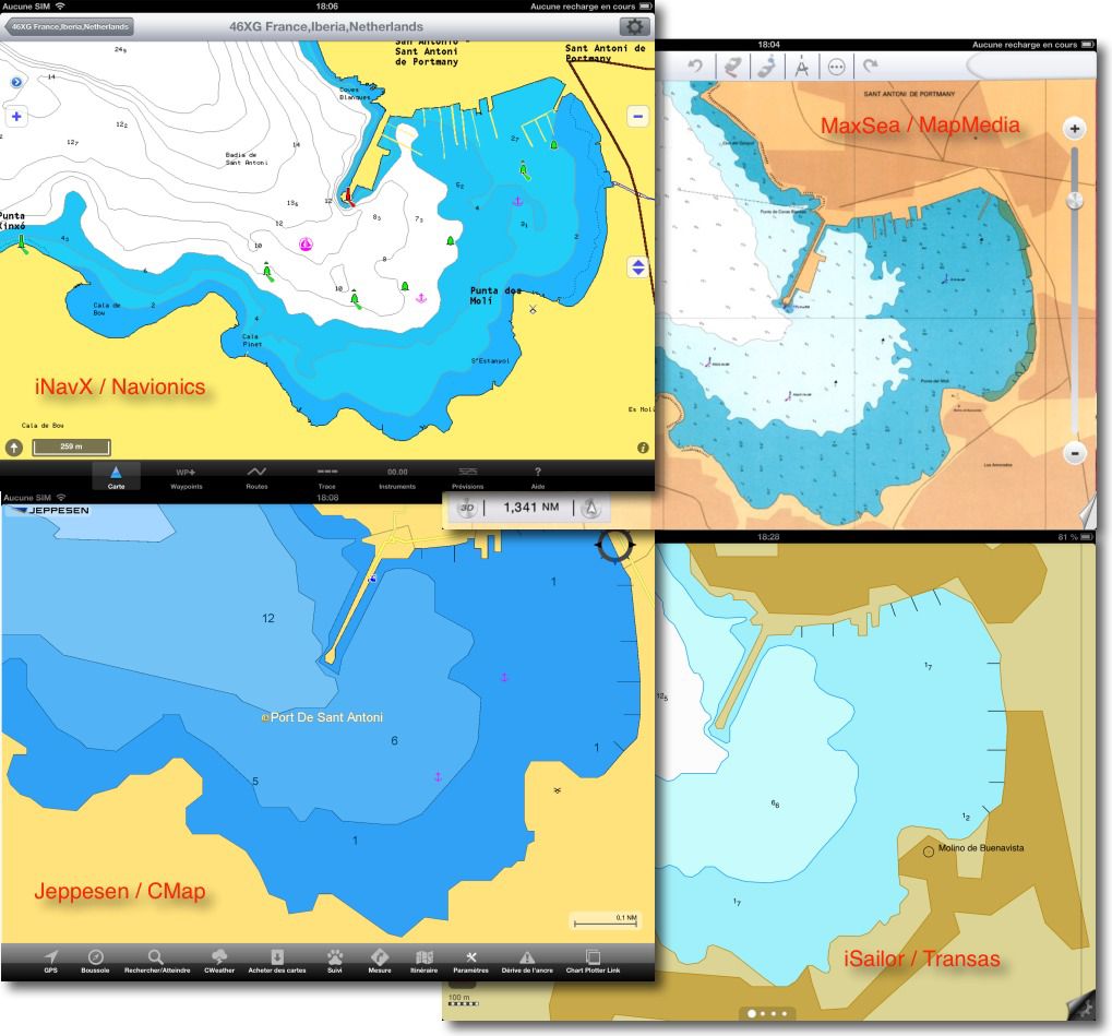
In this chapter, I will certainly make dissatisfied, But it wants to be useful. Accustomed that we are, we French boaters, using for decades a formal charting of extreme quality (SHOM), with a permanent update service, we are entitled to have requirements for electronic charting. It is about maritime security. And in this respect there is quite a work to do by publishers. They can clear itself by clauses to protect them from any legal recourse, that each user must accept by opening his favorite application, The fact remains that these "navigation aids" have become, for many boaters, the only source of cartographic information onboard. This is the inevitable course of things. It is therefore unacceptable to see cartographic representations without any detail (Timezero/MapMedia3), obsolete charts (Garmin/BlueChart (²), non existent marks or buildings several years after construction, And this in the majority of publishers.

The highly frequented port of Ciutadella, Minorca. Navionics is the only one to represent the pontoons, But it still lacks the n ° 1 which hosts tourist boats outside, and to which we were moored on catway inside.
Same thing in the following example, landing at San Antonio, Ibiza. Only Navionics shows real up-to-date markup and existing pontoon in north marina. The others are completely approximate, It's regrettable.
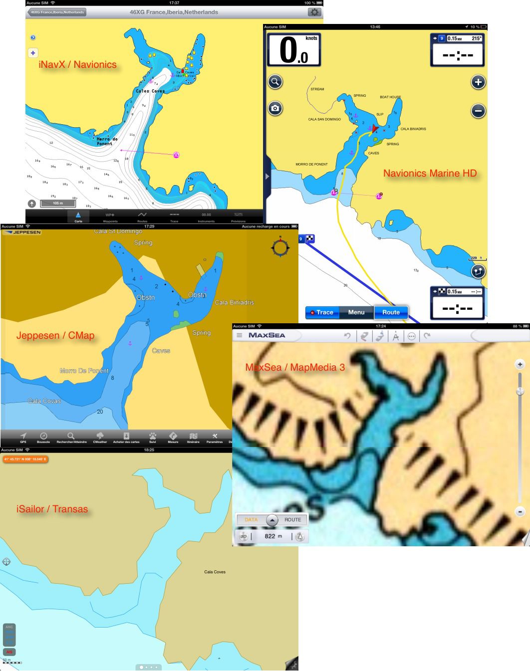
These are the pleasure ports frequented by hundreds of boats. But what about dreams of the north coast of Mallorca or the southern coast of Menorca ? I let you judge :
Below the Cala Coves. Useless to try to enter with poor visibility or without depth sounder with TimeZero, The southern coast of Minorca has no detail (I said that I downloaded all the charts). Navionics in iNavX (July edition 2013) presents curiously soundings and textual information different than Navionics Marine HD Europe (version 4.7). Again the markup is the most up -to -date with Incax/Navionics, in accordance with that encountered.
In conclusion
I remain quite skeptical to the vagueness of some charts. Navionics charts and Plan2Nav (Jeppesen/CMap), undisputed leaders for chartplotters for over two decades, are the most advanced in this domain. It is only a shame that Navionics do not provide, with the charting available on the X-Traverse server, the same information database as in its own applications, since in any case he wins on the two markets. iSailor uses very nice Transas charting, But it is seriously lacking in details, and the sequence of zoom levels lacks continuity in the display of data. The application does not provide setup to delete the light sectors that pollute display some zoom levels, or adjust the display of marks.
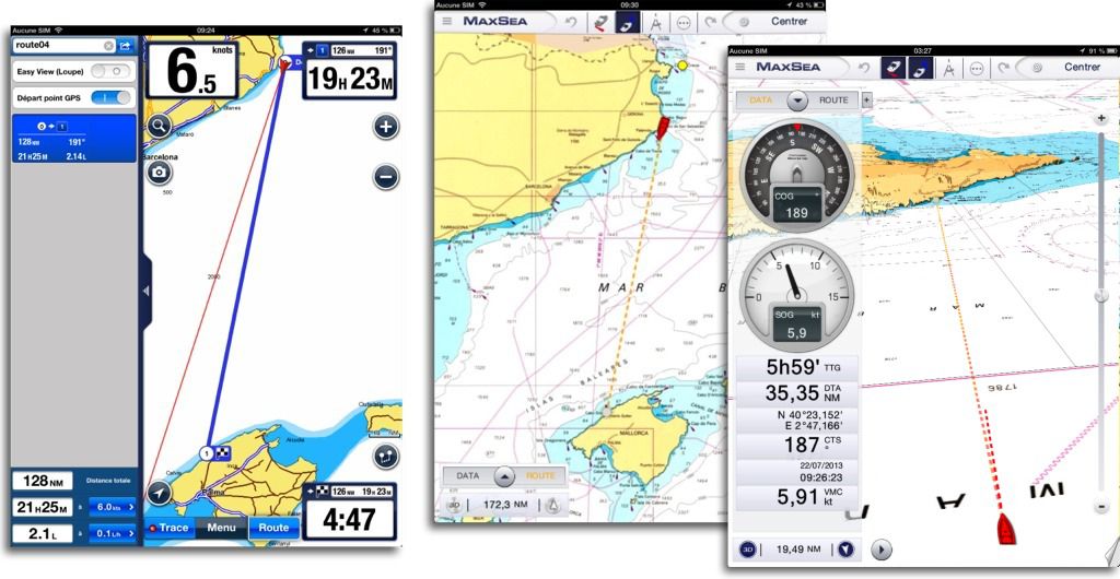
The big disappointment comes from Maxsea TimeZero, more exactly MapMedia raster charting. As long as I walked around the harbor of Hyères, no worries, All details are there. But as soon as you go south, even a large port like Barcelona has display gaps (missing lights in the example below :
MaxSea has announced the use of a vector charting soon in a future release. It is to be hoped. I have already expressed, and I still say that the raster chart is no longer suited to modern computing devices such as tablets, Smartphones and small laptops. Poorly convenient display, file size too big, No data base, Update difficulty, aso.
I voluntarily dismissed Imray because its raster charting for the Mediterranean is terrific poverty. It only has a few major routing charts and few approach details charts. Chart overlays are laborious, The very difficult to use application, ergonomics of a rare poverty. In short for me unusable.
About Navionics, The regularity of updates and global coverage make it the reference publisher. However, the new deal for updating Navionics Marine applications asks me. I will talk about it in a future post.
—
(¹) Indicating that Navionics Marine HD database is absent from Navionics sold by X-Traverse channel ! Not cool…
(²) San Antonio, Ibiza, last correction 26 th 2009.
—
Related articles :
The stakeholders of electronic charting
—



Hello Francis, Too bad for the Grand Pavois and we risk not seeing us again before my next departure. And suddenly I came to take a look at your article. Indeed to go to Nouméa, I have a concern, I go through Panama and the Pacific. Inadox that I start to know well (Several deckchairs to the Antilles, Panama, the Bahamas, Cuba or northern Annapolis, Several Transmed to Greece and Turkey, 4 Transpac to Tahiti) gives me more than satisfaction. I no longer embark on a computer, I chose to have 2 Ipad (in case of breakdown) With the "magic trilogy", Weather4D PRO et Iridium AxcessPoint (Some bugs in this last app during my last deckchair). But… For Noumea, iNavX (just like Macenc) does not know how to pass the antemeridian. So I gave myself to a small comparison, which may be the subject of one of the next posts. In two words Isailor does not know how to do it, Timezero yes, but, unless, does not offer Pacific cartography. Still missed for me. I think I know that OPENCPL, But before I left with a laptop… Other little indication : I gave myself a transponder AIS XB8000 Vesper Marine. I can't use the transmitter, Not being a "station" with its MMSI, But I hope to use the receiver (I was a little scared recently by landing at Cape St. Vincent), Timezero does not know how to display the AIS, the other two if, Tested on Incax, with a question : When I stop I did not see a CPA and TCPA field appear. Finally Infox offers the choice between ortho and loxodromy, It is not expressed (unless I'm mistaken,) In the other two apps, donc ortho or loxo ? I think I may offer myself a cartography for Isailor, No doubt not for tz (I will wait for the vector version and the Pacific). I will send you a little comparison, But an update of these comparisons may prevail no ? Unless you are waiting for the Android version, Olivier and Weather4D took the plunge, It’s also done I think with axcesspoint then when in adefox under Android ? Incax which remains by far what is done better under iPad. Friendships
Christophe
The passage of the antemeridian is a real problem, And since I found that Navionics Marine Asia&Africa did it, I will question Incax and the others.
Regarding the ais in Inavox, CPA and TCPA calculations are not done when the boat is motionless (shift < 0,3 nds), et ne sont donc pas affichés dans les infos de la cible. Si tu es au mouillage et qu'une cible vient sur toi, pas de calcul. La prochaine version de iNavX aura une fonction d'alarme sur cible AIS réglable (dans les réglages des instruments).
Bravo for this article and comparison. I also thought that the raster "type" Shom was the best to navigate , But I changed my mind this summer by comparing with the Isilor/Transas green cards. In the West and Anglo Norman Channel Zone The info is very comparable to the SHOM paper cards precisely. with the fluidity of the vector in addition and the info on the points of interest and the markup. For Anglo Norman, transas cards use basic data provided by Ukho the hydrographic service of His Majesty. Serious therefore. For areas further south I don't know ?
Hello Francis, I have been sailing with Inapx since always and don't want to change it's great.
I do a lot of coastal and I can say that rare are the surprises.
For coastal details I sometimes use Iphigenia with the coast card option and I can say it's really great, Except that we must load tiles before navigation otherwise it is long to load.
I will see you at the Grand Pavois to show you on iPhone and iPad.
Thank you again for your great work,
Laurent Camus, La Rochelle
Hello Francis
I use Inapx on iPad; I downloaded the TZ application.(Brittany)
Conclusions of our experience :
Inadox is much more complete than TZ in navigation, more "navy" I would say, But I admit to consult TZ for cards on the more informative anchorage zones on the nature of the funds and more "pleasant" to read.
The iPad allows this luxury to reasonable cost
Thank you for this very educational article. We only sailed in the Aegean Sea with Incax and Weather4D without unpleasant surprises.
Sincerely.
I usually use Invox and Navionics Marine HD, Ainsi that Weather4d Pro.
The first seems more pleasant to me, easier to manage roads, But the translation into Spanish makes it almost unusable, and change the language of the iPad each time becomes painful. It's a shame, I even suggested that the developer eliminate the Spanish version and leave only the French and/or English version.
I have already pointed out to Maxsea on mapmedia2 a size error in the northern bay of Stornway (Exterior Hebrides) or the scan of admiralty cards reported a rock in the scale 1/100.000 In the middle of the bay, But the same rock was absent on the map at 1/20.000 ! This rock was present on CMAPs and on Navionics. The cards had been updated at the start of the summer 2011. When we choose this bay to wet, Good evening the damage !
Conclusion, like professionals, There are two electronic carto systems on board for safety.
Sincerely
Exactly as for the Barcelona card which displays the portes of the port on the map on a larger scale, But who disappear from the retail card. Dangerous for a night entry without any other source of information.
Finally each card has its favorite field …
– If it is for Hauturière navigation, We will choose Incax (To dialogue with Weather 4D among others) ;
– If it is for poi information, on choisira Navionics Marine HD ;
– If it is for the details of the ribs and ports, We will choose … iNavX ?
… until updates and deep changes arrive in each of the software.
I just have ?
Je n’ai cependant pas très bien compris cette histoire de base absente si achat par X-Traverse. Quel est l’autre source d’achat (incluant la base de donnée) ? Quelle différence de tarifs ? Parce que si il suffit de payer un peu plus cher en passant par autre chose que X-Traverse pour avoir tout ce qu’il faut dans iNavX et en faisant l’économie de Navionics Marine HD , voilà peut-être une bonne solution …
(merci 🙂 )
Pour le choix, c’est effectivement à vous que revient la sélection des critères prioritaires.
For peas, ce sont des données stockées dans un fichier (une base de données) lié à l’application. Un tap sur un élément particulier (Port de plaisance, par exemplke) calls by an indexing system the data relating to this element. This is the principle of vector cartography that allows information to be associated with cards. The file used by Navionics Marine, So included in this application, simply does not exist in the files (Region) Navionics cards distributed by the X-Traverse server. It is a voluntary choice of the company Navionics.
Thank you for these experiences lived at sea, And for these uncompromising comments.