 After several months of intensive development and testing, under the conditions mentioned in a previous post, Olivier Bouyssou will offer his latest version of Weather4D PRO 1.3.0. At no additional cost, the routing module will simply be added with the update !
A career as a computer developer in the service of technical engineering combined with a solid mathematical background (¹) has enabled it to develop routing algorithms that have nothing to envy to the market leaders (²). Added to an interface that everyone agrees with, this new advanced feature that will appeal to both racers and cruisers, want to optimize their trips in the best conditions of safety and comfort. The new features will :
Routing :
- Routing isochronous mixed (Sail and engine).
- Polar efficiency adjustment in percentage.
- Management of polar combined with multiple sails sets.
- Refreshment of a route from actual location.
- Importing Fleeces (CSV files) by the "Open in… ”.
- Export route calculated by mail and "Open in… ”.
- Conversion of the calculated route to a "normal" route (export to iNavX).
GRIB Files :
- Request for fine grids files WRF by email (email, XGate, Iridium Mail) as for the GFS.
Implementation routing requires to combine two main information : a (or more) Polar speed and weather forecast covering the estimated duration of the predicted course.
Polar speed
Usually supplied by architects for cruise ships for a few years, they are only from numerical calculations related to standard plans of hull and sail. They can be used by assigning them a percentage of reduced or increased efficiency depending on the state of the sea, sail set used, of the helmsman (experienced, beginner or autopilot), aso.
Establish a polar diagram in real life, as is the practice for regatta boats, is a long and tedious empirical work that requires great rigor (Heading, Sea State, Sail Trimming, aso.) beyond the reach of all boaters. Nevertheless, more accurate polar and more routing close to reality.
In all cases the polar is entered on a spreadsheet (Excel, Numbers or other) and saved in CSV format (³). Just send it by email and retrieve it on the iPad/iPhone by tapping on the attached file and the " Open with… Weather4D », or to transfer it with an application such as Files Connect. The table must be simple type with two entries. In columns wind speeds, in increments of 5 or 10 knots, beginning with a column zero knot. In rows boat wind angles relative to the apparent wind, from 0° up to 180°, in increments of 5, 10 or 15° according to the data available, beginning with a row zero degrees. The starting row/column cell must contain the acronym "TWA" ”, a dot as decimal, a comma or semicolon as a field separator.
Optimized route creation
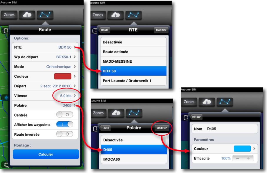
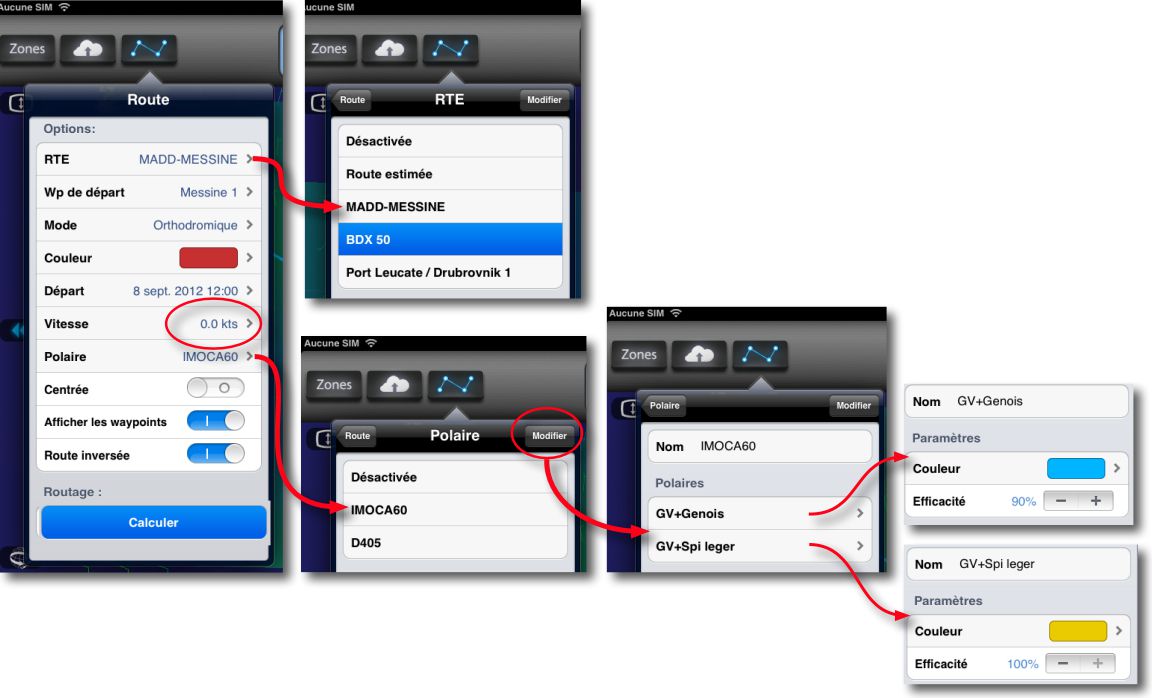
After creating a weather forecast area, and then made a GRIB file request over a period long enough to cover the supposed duration of the journey, you have to import a route composed of the successive waypoints in GPX or KML format (³) from iNavX or any other navigation application. After the forecast is selected, recorded route is chosen and select the route settings :
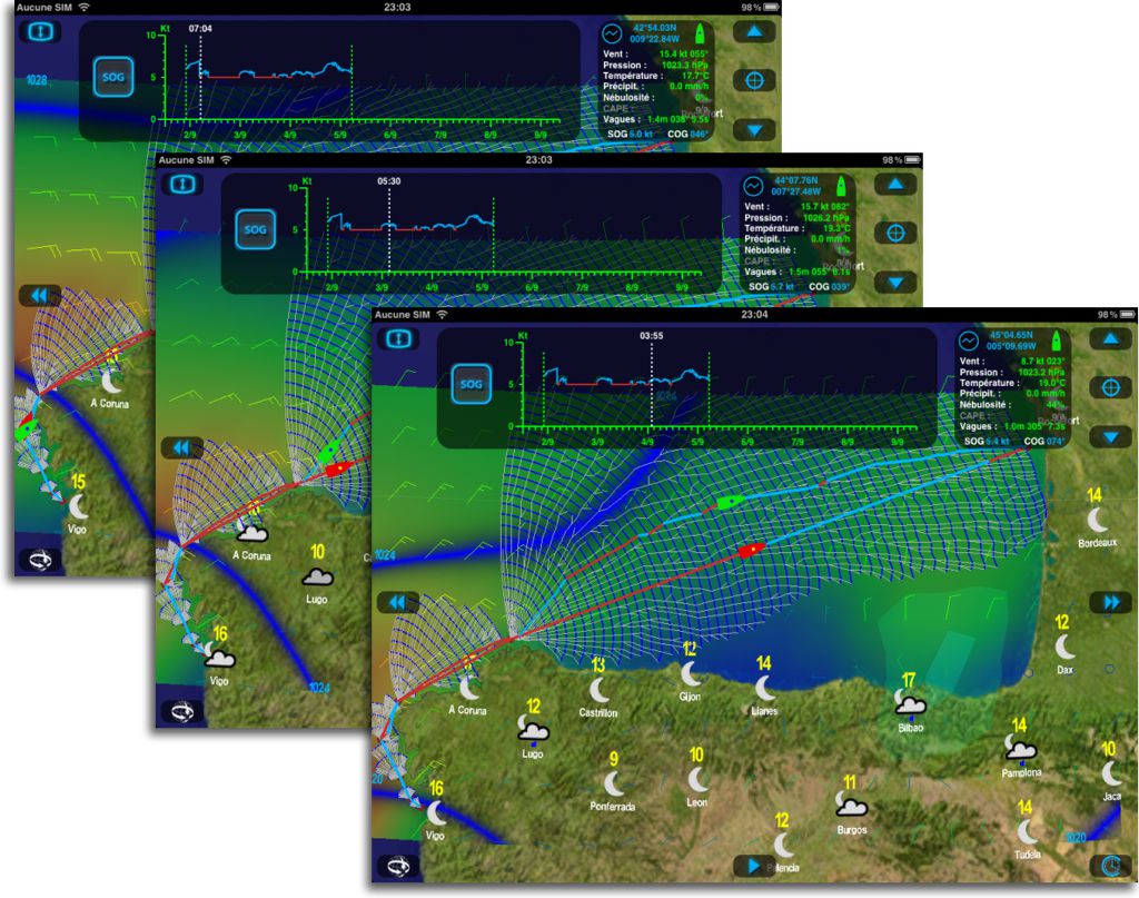
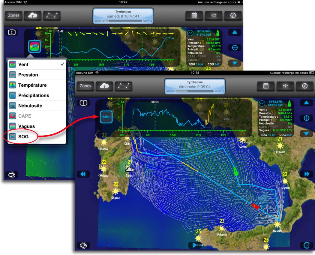
In this example, the imported road is called BDX 50, the speed under sail below which the engine is put on a direct course is 5 knots, the fleece is D405 (Dufour 405), you can change route color and efficiency percentage. Once the settings are entered, select "Calculate" button. The application starts the creation of isochrones which ends with the display of the optimized route. In blue, the sections under sail, in red the motor sections (5 knots). We can compare the optimized progress at any point of the weather forecast, by scrolling through it, with the direct reference route.
The routing module also allows to combine several "sail sets" for a boat, by combining several fleeces. In example below, IMOCA 60′ a set of "GV Genoa" and "GV Light Spi".
Calculation, without the use of the engine (speed = 0 knots), allows you to view the route sections with Genoa and those with light Spinnaker with editable colors, always compared to the direct reference route.
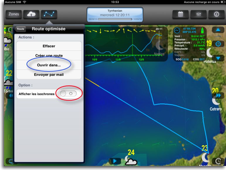
For better readability of weather data, You can choose not to display isochrones :
In addition you can choose at any time of the journey current positon as start waypoint in the route. In this case, route is refreshed in real time and you must choose the next waypoint. The change of the next waypoint is done automatically when passing the waypoint (circle of 500 meters high). The routing can then be recalculated from the current position.
Finally, the optimized route may be transferred to an application like iNavX to activate as route to go. Use the " Open with… ”. Tracking the boat's position, with Weather4D PRO as with iNavX, will allow you to check the progress against the routing, in order to, in case of track error, start a new calculation with updated data (Weather forecast, Polar efficiency percentage).
Comparative
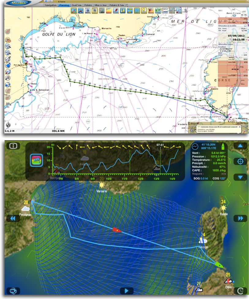
A comparison of routing calculations between Weather4D PRO and the routing module of MaxSea Time Zero, with identical data (polar, GRIB and routes), shows similarity in routing strategies and a slight advantage to Weather4D PRO on timing, Examples :
Route Port-Leucate to La Maddalena
Back Route La Maddalena to Port Leucate
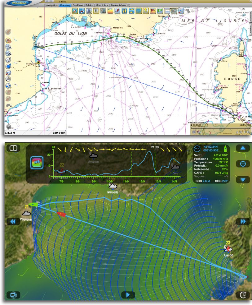
Arrival the 13 at 1:35 am with MaxSea, the 12 at 9:20 pm with W4D PRO.
Note the passage to land with MaxSea, surprising !
Only remains to integrate sea state, Under development, and tidal currents when truly reliable files are available.
But, already, this new feature push Weather4D PRO applications on top of main French routing apps like MaxSea and Adrena, while addressing a wide audience of recreational sailors thanks to a particularly competitive price.
As a "Final Candidate" at the time of publication of this post, The result is frankly… impressive !
—
(¹) View Olivier Bouyssou's profile
(²) See the excellent article by Olivier Chapuis in Voiles et Voiliers dated September.
(³) See Files format In the Glossary.
—


That's what I did but the export in weather is not done….
Bonjour,
Could you please send me your fleece file @ ob@weather4d.com
Thanks in advance.
–Olivier Bouyssou
Here is a link that can help with the making of polar files :
http://www.ffvoile.net/ffv/web/pratique/habitable/ORC_IMS/certificats.asp
Most of the production boats that race from time to time have been measured.
However, it must be added :
– One column 0 TWS (boat speed at 0Kt)
– A column above 20Kt (25Kt for example) with also a boat speed of 0Kt.
– One row 180 TWA with also a boat speed of 0Kt.
Thus, the routing will not offer routes with a TWS > 20kt and a TWA > 150°
Hope this help.
Good evening,
Can you give me some details on how to transform a polar xls file into a csv file??
I tried but it doesn't work: it fails to open in Weather 4d
Thank you for your help
In Excel : Menu " File> Save under… » choose « Format > CSV in the drop-down box.
Bonjour,
Unless I'm mistaken,, The update is not available ? Is this normal ?
And I take this opportunity to ask another question : can we view the iPhone on the ipad (my iPad is only wifi, so it's difficult to use Navionics and weather4D once you're on board !…).
Thank you in advance.
Better winds,
If you mean you want to use your iPhone's GPS for your iPad, it's possible with GPS2IP which I have already mentioned (iPad 2 and +) via Bluetooth. But the best solution is to use a Bluetooth GPS like GNS 1000 Recently Presented in present blog.
The Weather4D Pro Update (v1.3.0) is available on the App Store !
What's new :
– IOS compatibility 6.
– iPhone compatibility 5.
– Routing isochronous mixed (Sail and engine).
– Polar import in csv format.
– Management of polar combined with multiple sails sets.
– Great Circle email requests (Email, XGate, Iridium Mail).
– Managing a route from the current position.
During our stage between Chile and Easter Island, I prepared the road with successive simulations on W4D pro, because I lost the dongle of my Max Sea! The iPad therefore remained at the center of our concerns during the first week, and helped us to assess the weather situation by comparing the grib files received by Sailmail. At the end of the second week we were on Easter Island without ever having run out of wind! I'm looking forward to testing the "real" routing module between Tahiti and New Zealand. Congratulations and thanks to Olivier.