
 Since Garmin has acquired Navionics (¹), it will not take more than a year for Navionics also make its small (r)evolution in its flagship iOS and Android application . New logo, renouncing the multiplicity of applications, abandonment of duality iPad/iPhone, pricing standardization, Bring, among other changes, A little more consistency in the offer.
Recall that Navionics mainly targets, with its application Boating, coastal boaters customers, motorboat in fishing-drive or sailing day-boat, up to 10 nautical miles far from the coast. As a result, it focuses on 95% of the world's yachting with global map coverage, which has made the application widely leader in boating market.
To suit this customer target, a very easy application to use, without complicated TCP/IP connection or AIS reception, but the emphasis placed from the beginning in 2010 on community sharing (²), bathymetry (³) and some sounders connection.
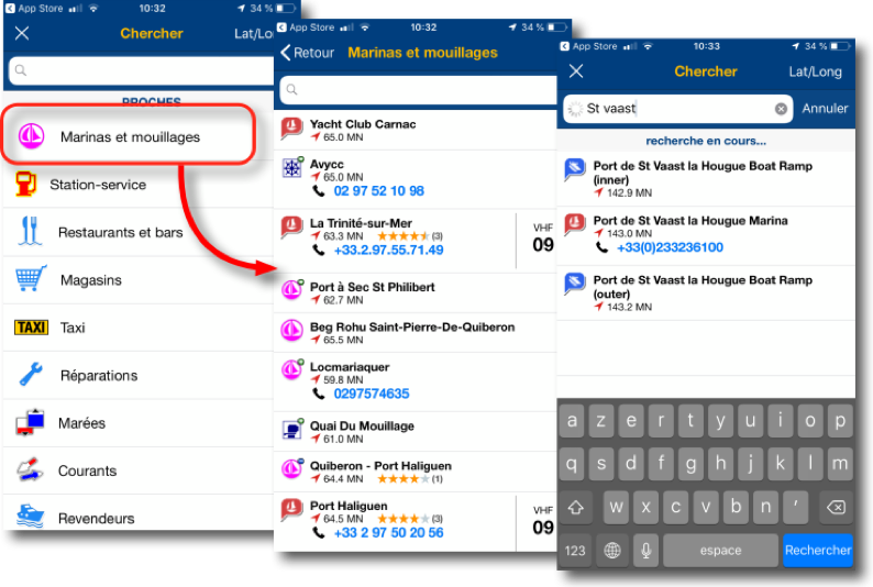
Henceforth, There will be only one application : Boating Marine & Lakes, to download for free, to test with a chart to select available during 10 days. Then you will have to buy. All legacy applications (Europe HD, "Boating HD", aso.) will be deleted, transfer to Boating Marine & Lakes can be done free of charge by following the proposed procedure. It can even restore purchased expired charts, but be careful : it will buy Navionics+ update to recover waypoints Goto function, Autorouting, tracks, aso.

With iPhone, You are quickly encouraged to create an account and define your profile
With Navionics+, the standard 2D charting is to purchase added with SonarChart. With Platinum+ we access to Navionics 3D charting but not for mobile, only for chartplotters with memory card.

Chart prices have been standardized but the division of regions are virtually unchanged
The user interface has been simplified and refreshed, with zooms in on browsing data.

The ActivCaptain information can now be displayed on the chart
It will appear the information from ActiveCaptain database, also acquired by Garmin, as well as data from Community Edits.
The information database is richly endowed
THE +
- Now single application for iPad / iPhone.
- Charting single price iPad / iPhone.
- Lower pricing ± 30% for iPad and ± same prices for iPhone.
- ActiveCaptain built-in.
- Sync with some trackers (only SonarCharts Live).
THE–
- Still not compatible with iOS SplitView function.
- WiFi compatibility only with some fishfinders (no NMEA or TCP/IP).
- Autorouting Dock-to-Dock function against the good seamanship.
- Tides and currents data only up to 3 days.
- Sonarchart card to use with great caution, To be banned for navigation (³).
Navionics Boating is therefore perfectly matched to its users target. It also helps to be a great addition to cartographic applications more oriented offshore cruising, Like Weather4D Routage & Navigation, whose charting issued from formal services does not present sufficient details in some remote places of the world.
I will never repeat it enough, given the low cost of applications and charts on mobile devices, it makes perfect sense to double sources of nautical information, to navigate so to speak with belt and suspenders. Too bad only that Boating does not yet support the function SplitView.
–––
(¹) Charting actors…
(²) Navionics Mobile and community sharing
(³) Marine Navionics always stronger
–––
Good evening,
At the end of 12 months, we can start again 50% price, If we don't pay, We keep the cards but we no longer have the updates or the special functions.
And yes when we paid for Apple, We didn't pay at Google. On the other hand if we stay in one of the 2, We can recover licenses on several tablets and smartphones. Just use the same identifier on each machine with Apple or Google vis -à -vis, and also at Navionics. Rien ne se perd, tout est dans le Cloud, marqué par votre identifiant.
Merci pour l’article. L’abonnement est-il à renouveler chaque année? Je suppose qu’il n’est pas possible avec un seul abonnement d’installer les cartes sur Ipad et sur téléphone Android…
Merci pour l’article.
158€ pour les cartes de France métro uniquement…
Mise à jour pendant les 12 mois suivant l’achat.
Pas donné lorsque l’on compare à Géogarage 🙂
Maintenant, pour ceux qui ne peuvent faire autrement car équipé traceur fixe et autre engins fonctionnant avec des cartes SD ou CF.
Pour les coins reculés, il y a la base UK qui se tient plutôt pas mal.
André
You confuse cards for tracers and those for mobile applications that are 4 to 5 times cheaper : 31 € for Western Europe, 40€ for the British Islands, aso.
Thank you Francis,`I agree on everything, except …
"Function Dock-to-Dock motorway against marine common sense. ”
At your disposal to deepen. I am part of the group that has developed and tested highway for Navionics.
Certainly at first errors were numerous especially when channels crossed and nasty pebbles had a markup not easy to understand. Now I can't blame him, at least for a boat to the engine. For veil in my kind it is missing the "Weather Routing" , But I use other specialized products for this.
For gaps as NMea frames, Ais and Mob is indeed incomprehensible.
For export/import of waypoints/traces/roads in GPX format it could come this year, finally maybe.
Bonjour,
Always clear and precise article as usual.
Thank you and see you soon
François
Bonjour
I would add a weak point -tredestory for me, particularly in coastal where traffic is intense- The lack of integration of AIS frames and therefore no calculation of CPA/TCPA. Obliged to have an additional screen.