Once will not hurt, I relayed the information in French from Blog Panbo which have interest for Apple mobile devices users.
Community Sharing
- User Generated Content (User-generated content)
- Social Mapping or Social Charting (Social Mapping)
- Crowd Sourcing (Crowd sourcing)
All these english words mean the same principle : sharing to the community all maritime information collected by each charting software user. In other words, each boater can use its navigation application to share all information on any changes observed over charts. This can concern the markup, the erection of a new quay or the appearance of new catways in a harbour, practical information on new harbourt services, incorrect positioning of a rock or the appearance of an uncharted shoal, aso.
The purpose is not new. In the USA for several years, the charismatic Jeffrey Siegel, website founder Active Captain, preaches to this yachtmen interactivity to establish Nautical Guides updated continuously by the boaters themselves.

Giuseppe Carnevali
What is new, and reveals by Ben Ellison on his blog Panbo, is the integration by Navionics of this feature in version 5.0 of its application Navionics Mobile, currently being deployed on the AppStore. Navionics founder himself, Giuseppe Carnevali, has recently demonstrated his enthusiasm about enabling interested Navionics users to share data of all sorts, some of which could be validated and added to the chart database of the company, for the benefit of all users.
« User Generated Content » par Navionics
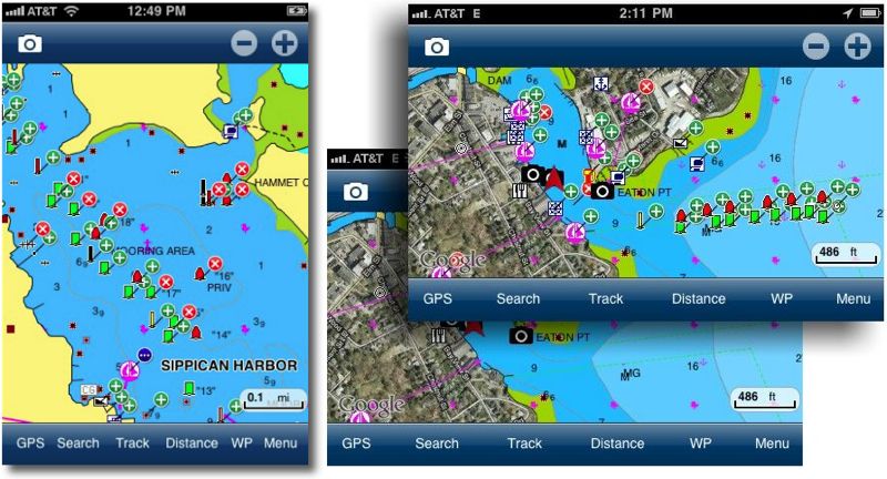
With the community screen ON, users have access to all UGC. A red “x” indicates deletion, and « + » green indicates an addition, a blue dot indicates textual information.
Navionics Mobile 5 present a Community Layer, which will allow, on chart, to edit information and comments, and overall to place marks on the chart which will be immediately seen by all users. These marks are stored as a bunch of icons pages, classified by themes, that the user can select to place on the chart, then provide a description and detailed information. This “community screen” can be activated or deactivated to display or not the elements added to the map.
The icon entry and writing screens
Revolution ?
" A revolution in marine cartography begins…
and it starts with you ! "
This is the slogan displayed by Navionics. Good. But this raises some questions in my mind.
First, I learned navigation by a quite blind trust in marine charts of our national Hydrographic Service, and I have always taken care to update them as corrections are published.
Using Navionics charts with MacENC and iNavX, updates only every 2 or 3 years old, I exchange the security of frequent updates (obtained with a subscription to official ENCs) against the best Price/Quality ratio, and especially same charting on all my devices (Mac, iPhone, iPad ). Although this charting is made with the utmost care from official documents, I remain reasonably cautious when using them..
What will it be, in addition, the trust afforded to information offered by unknown mariners, not more than me professional hydrographers qualified ? As it is only information on harbour facilities, new services or points of interest, no fear to have, the most recent information from passing sailors will be welcome.
But when it comes to new marking, displaced or absent, new fires or on the contrary extinguished, the positioning of a shoal or rock, or any other information regarding ship safety, what credit can be given to it ? Which competent service will travel to verify and confirm the information, the exact position, aso.?
On his Facebook page, Navionics answers this question rather evasively in the comments :
" At time, User contributions will be saved in the community screen. In time, Navionics plans to verify these contributions and decide to implement them in official maps. "
I know social media is trendy, and this creation is a good example applied to pleasure boating. Despite everything, I remain quite doubtful about its real interest in terms of security..
Marketing, or breakthrough for charting ? The debate is open.
M. Fustier, thank you for your interest in our applications and for the way you cover this subject on your blog. Just a clarification, all Navionics charts are updated every year, not every 2/3 years old. Due to the contract that binds us to SHOM, we integrate at least once a year all the new maps and corrections provided by SHOM.. For all other questions, we remain at your disposal for any further information.
Sincerely
Thanks to Navionics for this correction which will undoubtedly satisfy users, and thank you to them for visiting this modest blog with responsiveness. It seems essential to me to provide the most accurate information possible to facilitate the commercial choices of navigators..
I use a GPS a lot (TomTom) for my work. At times he positions me more than 800 m from the road. As if I were driving in the open fields !
What about marine GPS…
I know I'm driving on asphalt even if the GPS is wrong. At sea who controls his GPS ?
I have never had an error when entering a port, but I remain vigilant.
Happy sailing.
MacENC
RV
We're not really on topic, but it doesn't matter. If the TomTom's GPS stalls in the car, it is, either it is not well positioned, either the windshield is a recent athermal one which reduces reception, either the chipset is insufficient. As the latter cause seems unlikely (find out more on the forum GPS Passion), one of the other two causes must probably be the correct one.
Concerning maritime GPS, whatever the brand, fixed or portable, today they are all of formidable precision. Regarding iPhones and iPads, I send you back to detailed articles that I have written on the subject.