Hear, hear, hardy boaters, new Weather4D applications come up !
I wrote “the” in the plural. The two historical applications of Sarl APP4NAV, Weather4D (th 2011) and Weather4D Pro (November 2011 ), change to the user interface of the now famous application Weather4D 2.0, which had been the subject of a complete review of its development published in December 2015. In order to make the range more coherent, the names of the three applications are harmonized :
This change is made only by the way of free updates. In addition, the valid weather subscriptions in each application are kept. The icing on the cake, three tutorials made by myself are now to download, for free ! They are designed on the same pattern as that of Weather4D (ex-2.0) in French and English.
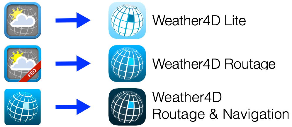
![]() Weather4D Lite is for those who simply want a powerful graphic weather application, based on GRIB weather and ocean files, equipped with a sophisticated interface, suitable for nautical leisure activities as well as for all other land-based leisure activities.
Weather4D Lite is for those who simply want a powerful graphic weather application, based on GRIB weather and ocean files, equipped with a sophisticated interface, suitable for nautical leisure activities as well as for all other land-based leisure activities.
![]() Weather4D Routage will usefully complete, like the Pro version did, the need for high level routing for boaters already provided with their favorite navigation app : iNavX, iSailor or other, able to import and export routes. In addition they will benefit from the multi-routing of Navigation Version.
Weather4D Routage will usefully complete, like the Pro version did, the need for high level routing for boaters already provided with their favorite navigation app : iNavX, iSailor or other, able to import and export routes. In addition they will benefit from the multi-routing of Navigation Version.
![]() Weather4D Routage & Navigation, flagship of developer APP4NAV, will satisfy those waiting for an all-in-one application combining GRIB weather and ocean files, multi-routing, and complete functions of charting navigation, and the integration of onboard instrumentation. The update will include a significant number of new features.
Weather4D Routage & Navigation, flagship of developer APP4NAV, will satisfy those waiting for an all-in-one application combining GRIB weather and ocean files, multi-routing, and complete functions of charting navigation, and the integration of onboard instrumentation. The update will include a significant number of new features.
New in Lite version
Common Settings
- Safe Mode
- Support Iridium GO!™
Advanced Management of locations by category
- Creating a location (waypoint, THEN)
- Creating categories for registered location
- Assignment of location in a category
- Add a name, of an icon, display settings
- Attachment to an area, or global (all areas)
- Quick access in Target menu
- Creation/modification entering latitude/longitude coordinates
- Individual modification, overall or by category, locations
- Tapping on a location opens a creation context menu / modification / suppression
- Tapping an icon opens a creation context menu
Weather
- Extension up to 16 days of GFS models
- Added ARPEGE Europe (0,1°) and global (0,5°) to 4 days
- Added ICON-EU (0,625°) et ICON Global (0,125°) to 5 days
- Adding MFWAM wave models by Meteo-France, 3 resolutions for 3 coverages : Global (world), Europe and France
- Adding NCOM current models at 1/30 ° (2 NM) for US and Caribbean coastal region
New in Routing
In addition to the previous functions :
- Importing waypoints in KML format (in addition to GPX)
- Creation of routes by context menu with a tap on a target or location, then by successive taps on saved places displayed on the map (in addition to the conventional method from a target and then "Begin a route"
- Exporting a routing table .xlsx format, Excel and Numbers compatible spreadsheet
New in Routing & Navigation
In addition to the previous functions :
Charting
- Adding an "Update" button on each chart area as soon as a downloaded update has been published by Geogarage, valid for all publishers. A tap on the button starts the download of the update by replacing the modified tiles.
- Chart orientation North Up, COG Up, HDG (Compass head) Up, BTW (bearing to waypoint) Up.
NMEA
- Extension of output NMEA sentences to appropriate multiplexers and gateways.
And to follow up this (r)evolution, the website weather4d.com will also have a brand new interface, more dynamic, better suited to international application expansion.

Bonjour
Is it scheduled soon to have routing functions with a pivot point, grib alteration, D'Opor de Wills au Format Grb2? If yes, When?
Good day
VIncent
1- « Point pivo »: To have… Zones d’exclusion : Oui
2- "Grib alteration": Oui
3- «GRIB2»: Oui
When ? 1 and 2 Soon, 3 probably for the fall.
Hello Francis,
Do you have the program
>The addition of a man's function to the sea ?
> Mooring alarm ?
Merci
Good evening Marc
Yes it is planned. For men in sea there will be a quick access button to trigger the alarm and specific follow -up of the target. An option will take into account the measured current or from a current model.
Pour l’alarme de mouillage j’ai prévu un instrument dédié et la possibilité d’un report d’alarme sur un autre appareil via une notification.
Ces fonctions nécessitent encore quelques tests en conditions réelles.
Je découvre avec beaucoup d intérêt . Je voulais tester avant une transat . Je suis conquis . Merci à Francis pour les guides
Friendly
Henri
Merci à « toute » l’equipe, ces applications sont de petits bijoux accompagnées d’un support attentif et efficace; le tout à un prix défiant toute concurrence. Je conseille aux grincheux d’aller voir les Adrenas ou les Squid de l’ancien monde.
Excellente nouvelle 😉
Merci à vous et Olivier Bouyssou
encore payer quoi!!!!!!!
For my program the old version summer very well can reinstall it ?
No. You have dozens of free weather applications, Don't deprive yourself.
@Thierry : There is a "free" culture in our country (and the neighbors) funny…
You have to understand that when it's free, So it is we who are the product and who are sold (Our data, Our behavior) to other companies.
The 1st goal of a commercial structure is to do … trade. Otherwise it would be called "non-profit organization for a general interest of general interest". I knew people who worked 70 hours a week voluntarily, Without any counterpart or defray , But the cause that was close to their hearts was very, very high (understand that it's still rare).
I guess (I may be wrong, Who knows) that Mr.. Fustier and M. Bouyssou does not live on air and salt water alone … nor that they have won the mega jackpot at Euromillion but that they have a super-cause that is close to their hearts : develop W4D for free for the happiness of boaters.
Yes it pays yes. Yes we would have liked free yes. No, Santa Claus does not exist, isn't it. If it's "too expensive", so it's only a matter of time for a competitor to offer such a (or better) for less …
There is another much cheaper option : Listen to the weather report on VHF (I would have told you by Navtex NX300D but it is an additional device to buy), raise your position to the sextant (there too the price ..), and trace your position and road on paper.
Speaking of a weather forecast model, I have the impression that there are three newcomers : MFAUM (global, Europe, France).
MFWAM is interesting, It's well seen. Much more precise than FNMOC. On the other hand "MFWAM France" does not seem to work.
MFWAM France takes perfectly, in the three applications.
Bonjour
With the GFS model I can no longer display the Myocean Ibi currents as in the old version
Merci
The three new versions are aligned with the same principle of weather subscription : The subscription is necessary for all models other than GFS. This also applies to ocean models. In return much more models are available for the same subscription price.
Merci 🙂
Mon serviteur me comble 🙂
Remerciement à Olivier BOUYSSOU!