Hear, hear, hardy boaters, new Weather4D applications come up !
I wrote “the” in the plural. The two historical applications of Sarl APP4NAV, Weather4D (th 2011) and Weather4D Pro (November 2011 ), change to the user interface of the now famous application Weather4D 2.0, which had been the subject of a complete review of its development published in December 2015. In order to make the range more coherent, the names of the three applications are harmonized :

This change is made only by the way of free updates. In addition, the valid weather subscriptions in each application are kept. The icing on the cake, three tutorials made by myself are now to download, for free ! They are designed on the same pattern as that of Weather4D (ex-2.0) in French and English.
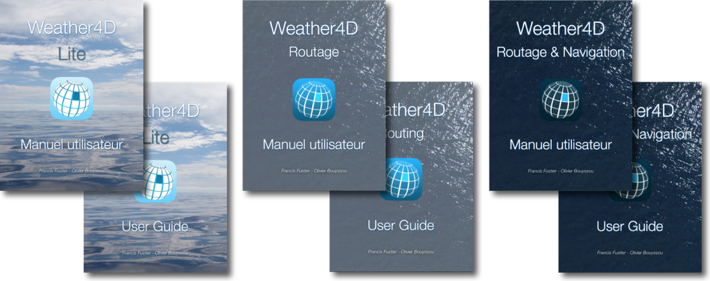
![]() Weather4D Lite is for those who simply want a powerful graphic weather application, based on GRIB weather and ocean files, equipped with a sophisticated interface, suitable for nautical leisure activities as well as for all other land-based leisure activities.
Weather4D Lite is for those who simply want a powerful graphic weather application, based on GRIB weather and ocean files, equipped with a sophisticated interface, suitable for nautical leisure activities as well as for all other land-based leisure activities.
![]() Weather4D Routage will usefully complete, like the Pro version did, the need for high level routing for boaters already provided with their favorite navigation app : iNavX, iSailor or other, able to import and export routes. In addition they will benefit from the multi-routing of Navigation Version.
Weather4D Routage will usefully complete, like the Pro version did, the need for high level routing for boaters already provided with their favorite navigation app : iNavX, iSailor or other, able to import and export routes. In addition they will benefit from the multi-routing of Navigation Version.
![]() Weather4D Routage & Navigation, flagship of developer APP4NAV, will satisfy those waiting for an all-in-one application combining GRIB weather and ocean files, multi-routing, and complete functions of charting navigation, and the integration of onboard instrumentation. The update will include a significant number of new features.
Weather4D Routage & Navigation, flagship of developer APP4NAV, will satisfy those waiting for an all-in-one application combining GRIB weather and ocean files, multi-routing, and complete functions of charting navigation, and the integration of onboard instrumentation. The update will include a significant number of new features.
New in Lite version
Common Settings
- Safe Mode
- Support Iridium GO!™
Advanced Management of locations by category
- Creating a location (waypoint, THEN)
- Creating categories for registered location
- Assignment of location in a category
- Add a name, of an icon, display settings
- Attachment to an area, or global (all areas)
- Quick access in Target menu
- Creation/modification entering latitude/longitude coordinates
- Individual modification, overall or by category, locations
- Tapping on a location opens a creation context menu / modification / suppression
- Tapping an icon opens a creation context menu
Weather
- Extension up to 16 days of GFS models
- Added ARPEGE Europe (0,1°) and global (0,5°) to 4 days
- Added ICON-EU (0,625°) et ICON Global (0,125°) to 5 days
- Adding MFWAM wave models by Meteo-France, 3 resolutions for 3 coverages : Global (world), Europe and France
- Adding NCOM current models at 1/30 ° (2 NM) for US and Caribbean coastal region
New in Routing
In addition to the previous functions :
- Importing waypoints in KML format (in addition to GPX)
- Creation of routes by context menu with a tap on a target or location, then by successive taps on saved places displayed on the map (in addition to the conventional method from a target and then "Begin a route"
- Exporting a routing table .xlsx format, Excel and Numbers compatible spreadsheet
New in Routing & Navigation
In addition to the previous functions :
Charting
- Adding an "Update" button on each chart area as soon as a downloaded update has been published by Geogarage, valid for all publishers. A tap on the button starts the download of the update by replacing the modified tiles.
- Chart orientation North Up, COG Up, HDG (Compass head) Up, BTW (bearing to waypoint) Up.
NMEA
- Extension of output NMEA sentences to appropriate multiplexers and gateways.
And to follow up this (r)evolution, the website weather4d.com will also have a brand new interface, more dynamic, better suited to international application expansion.

Hello to you and especially to Francis (of Stw's time),
I took the plunge (grand…) Going directly from InAvox to W4D R&N considering that it was time to move to more modern and more complete…
Some bugs at the start but the support is an iPad 2… IOS 9.3.5
When I start a road and try to follow it, W4D turns out simply…
Olivier questioned advice to disconnect the "iCloud synchronization" function on W4D and this seems to work even if I have not tested real navigation; Only in the garden. Corrective update should see the day after Olivier.
However, No operating problem on iPhone 6S…
On the other hand, Initially coming from Fugawi on PC, I had by passing on Inavox, recovered (by X-Traverse) My waypoints and roads collected over the years, Especially in coastal navigation. I particularly hold there because there are among others, number of "personal" anchorage and passage whose data I want to keep the data.
I tested the function to export the roads in Kml or GPX from Incax, But these roads are made up of waypoints not taking up the original names and simply numbered ; In addition, They remain in the roads and are not exported to the Waypoint base
So I did not find a Waypoint import system… Whatever the format… By going through direct export from Incax or by going through a complete file exported from Incax…
If one of you has the solution, I am obviously lessee with my thanks.
In the meantime and even if work on W4D R&N is remarkable, I stay (alas) On Inapox…
Yours sincerely
André
Bonjour,
I am sorry to arrive in this debate of unconditional Weather 4D by being negative…
I have been using this application in a pro version for a few years above all for the Gribs Arpege and/or Aroma from a sea corner… After having fun at the beginning to calculate roads with my fleeces (In interface with Incax).
I find it completely unacceptable to charge € 37.99 to iOS and € 10.00 users to those of Android. It's just an insolent commercial practice.
And if it is, You must now install a subscription on each iPad/iPhone of the identified user (What the advertising does not say).
Kind regards
A stuffing turkey, Stone
Applications have always provided for a high -resolution GRIB files. New developments have been lined up for the three versions, only offering the GFS model as standard. Valid subscriptions in previous versions have been propagated to new. The permanent provision of more than 35 Weather and oceanic models 4 times a day requires maintaining servers and bandwidths who have a high recurring cost. This cost requires pooling by subscriptions accordingly.
However, as already expressed precedely in this commentary wire, You can import Gribs files for free from this subscription link :
http://grib.weather4d.com/MyOcean/
Zone with par ex..
Or on http://openskiron.org/en/openwrf
Or any other free gribs supplier. These files are compatible with Weather4D all versions.
How to import a Weather routing 4 D routing to Carto de Ina X ? Merci
Thank you for your answer but can we use your own rasters without going through the platform and the same for future ENC S57 or 63 ? Please enlighten me
The export of roads and routages is illustrated in the user manual page 50.
Is it possible to integrate into Weather 4 D routing of raster cm cards 93 or vector ? Under which cards this router does it integrate its routing ?
Weather4D Routage & Navigation to date exclusively uses raster map from official hydrographic services and made available by the Geogarage platform. Support for ENC S57/S63 vector cards is being studied with this supplier.
Bonjour
Since today's update of the Weather4D Routage and Navigation tutorial, I can't read the videos included
IPad Air 2 11
Can we come back to the previous version ?
There has always been a video display bug in the iBooks app. When you have downloaded - or after an update - a book, must (sometimes) close, Hunt the application from the control center, Then relaunch iBooks. Videos appear.
I reported this bug to Apple there are ages, and never had a return.
Sincerely,
Bonjour,
Which should justify the transition to the road version & Navigation is the use of the application for navigation, The use of navy cards, you nmea, AIS etc… Otherwise, You use another navigation application (iNavX , iSailor, TZ etc…) and Weather4D Routing is used for weather and routing.
So much for the context as we imagined it.
The reason why SOG is no longer present is linked to the fact that in current development, The display of this information is dependent on navigation functions and in particular the navigation bar.
It takes me a little time to reorganize this part to find this display and the solution that is proposed (Display via the road board) is a palliative while waiting for a more suitable solution.
I hope you appreciate all the new features that this application offers as well as future developments.
Bonjour,
I am absolutely of the same opinion as Fred Comment from 31 March 2018 14:30, We lack the possibility of reading the theoretical speed directly in the application.
Your Excel or NUMBERS Table solution is not very practical.
This was basic in Weather 4D Pro. Would be a diverted way of obliging us to migrate to Weather 4D Routing and Navigation?
Hello Francis,
Update of the news made but the application seems unstable on iPad. When downloading gribs, Nothing happens. It fits then back on the main screen of the iPad,….
Do you have an idea ?
Patrick
The best is to address you directly to the support https://www.weather4d.com/fr/contact/
Apart from slowness and sometimes memory crashes with the oldest iPads (iPad 2) We have not noted instability using daily applications. Precise to the support of your iPad model, la version Weather4D, La Version iOS, possibly a screenshot illustrating your problem.
Bonjour,
I discovered last night. Weather 4D Pro evolution at Weather 4D Routage.
A little hard to get back to level when we had it,habit of the old version.
Certainly the fact of filing its roads directly on the ALD app to export a road from Navioncs and then import it to Weather4D is a very good evolution.
I miss it even an essential point in this version, it is to be able to read the theoretical speed (Fluid) During a routing, We had the course and especially the target speed.
No way to display this data with the Weather4D router version?
I already read a lot the manual, But without a subscription to Shom or other, I feel like it's not possible.
Can you confirm me.
Merci
Now you have the possibility of exporting your routing in the form of a walking board, compatible Excel ou Numbers, which can open directly in one or the other application to your iPad.
The same waves and current in the Mediterranean it is where ?
Default, Only the GFS is available without subscription for the three applications unlike Weather4D and Weather4D Pro which offered some additional models. However, If you had an in progress subscription, He continues on the new versions.
The three new versions are aligned with the same principle of weather subscription : The subscription is necessary for all models other than GFS. This also applies to ocean models. In return much more models are available for the same subscription price. Myocean Med currents and MFWAM waves are part of the annual subscription.
But you can import gribs from this link without subscription :
http://grib.weather4d.com/MyOcean/
Zone with par ex..
Or on http://openskiron.org/en/openwrf
These files are compatible with Weather4D all versions.
Bonjour
It is good but suddenly I end up with a completely different application and which seems to me less provided in adjustment… surely that I did not understand everything and the 4D pro tutorial booklet that I had bought I do what ?
Not at all, New applications include more extensive display settings, the possibility of downloading several weather models in addition to waves and currents, multi-routing, the creation of roads directly in the application, And many other things that you can discover with the new manual which is now free. The old tutorial therefore becomes obsolete.