The relationship of a recent experience of an iNavX user and Weather4D PRO routing function invites me to bring a warning to the attention of novices boaters in computer use.
A regatta course, departure from St Helier (Jersey) to arrival Granville, optimized with Weather4D PRO using fine grid GCWF model and MyOcean currents prediction, gave the following route in iNavX :

The optimized route transferred to iNavX
The Southeasterly moderate wind and favorable current North East of Jersey traced a route through the rocky plateau offshore Jersey Southeast. When optimizing, it is visible that the minimum distance constraint from the coast, defined as routing argument in Weather4D PRO, had kept its default value of 0 NM.

The optimized route runs on Violet Bank
It seems obvious that this route was not to be followed ! By studying the topology of places more closely, an option by passing the Violet Channel allowed to join the favorable current leaving the plateau of Arconie starboard. But for this it was necessary to have a good knowledge of the passage, of the direction of the current, and excellent visibility.
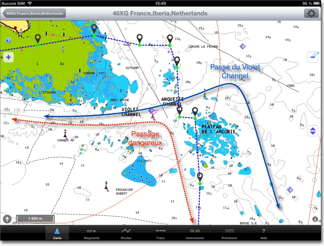
On screenshots above, we see the black dotted line track actually traveled by the sailor. The one, as an advised mariner, preferred to lose a few seats tacking healthy water rather than venturing into a tricky passage.
With the latest navigation applications associated with electronic charting, the comfort provided should not overshadow seamanship. As, contrary to appearance, an unknown part of imprecision remains linked to the implementation of these technologies.
Indeed, although the accuracy of the GPS positioning system is indisputable, it is not necessarily the same for charting. ENCs are, for the most part, reproductions of paper charts which lifted (hydrographic surveys) can sometimes be dated, in certain areas, from a time when positioning means were much less precise than today. On the other hand, reproduction techniques may be subject to error, as, in example, a bad datum conversion of original chart. Accordingly, if my position is accurate to within three meters, the outcropping rock shown on my electronic map a hundred meters from my position may very well, in reality, be only a few meters away.
In coastal regatta, shaving stones is often tempting, but beware of the false security that brings a ship icon scrolling on an electronic chart, this will never replace good verified alignments in the landscape around the boat (*).
–––
(*) See About alignments and sextant
–––
Thank you for this little information. It is true that my starting point was the port of Bonifacio. I also use the COAMPS Europe module for forecasts. – Mediterranean. I have not yet subscribed to Geat Circle, on the other hand I noticed that when Weather4D Pro displayed “import successful” without the second window in the background mentioning the imported models, the routing systematically mentioned “error impossible to calculate the routing” The minimum distance of the side for my routing is left at zero.
Thanks again for your help.
I have a “small” problem with Weather4D Pro, after importing my route with iNavX, I launch the routing on Weather4D and an error message appears telling me that the routing could not be calculated. But without more information. I've been shopping for a while to see where the problem comes from without finding a solution..
Can someone help me please ? and thank you in advance…
My email : jeanchav@hotmail.com
This can come from several causes :
1. The starting waypoint is outside the forecast area.
2. The start time is before the start of the forecast.
3. The waypoint is placed too close to the coast, the vector coastline having a precision of the order of 1000 meters. a GFS et 200 meters. and GCWF. Pay attention to the “Minimum distance from the coast” routing setting.
Clarification on routing quality and weather indications taken into account in W4D pro.
A few days ago I noticed that the weather forecasts that I downloaded with W4D in GCWF had nothing to do with the real conditions at sea. I was able to discuss this subject both with Olivier Bouyssou, the software designer, and Gerald Bibot from Great Circle..
I must say that it was the first time that I noticed double the differences between experienced reality and loaded grib files.. The explanation is simple in fact and it seems good to clarify it for all those who might be unaware of it.. W4D software takes synoptic wind into account. It does not take into account gusts and, in this period of the Normandy Channel Race, we were served in the Channel. Olivier is currently working on an upcoming update which will integrate gusts and wind into 925 mb. I don't know if this update will be accessible to everyone or only to those who have subscribed to the Great Circle fine knit subscription. ? We bet that when it becomes available we will be close to perfection with this brilliant tool.. En attendant je profite du fait que mon abonnement Great Circle par W4D donne un droit sur la même période à l’ensemble des données du site Belge pour croiser les infos de W4D avec celles de Squid2. Mais là je sais que je sors un peu du cadre du site de Francis puisqu’il faut un PC et internet à bord….
En espérant que cette précision apporte un plus aux utilisateurs de W4D et pourquoi pas suscite un commentaire avisé de Mr. Fustier
Mr. Fustier répond bien volontiers 🙂
J’apprécie cette interractivité entre les utilisateurs et le développeur, qui est aussi, I remind him, un navigateur. Il est impossible pour les modestes testeurs, of which I am part, de rencontrer tous les cas de figure en navigation. Tes retours d’expérience, those of Jean and a few others allow us to advance the application for the greatest benefit of all. I would say, covering the song by Michel Fugain : Bravo and thank you !
Thanks to Francis for these details full of “nautical” common sense..
It is true that advances in electronics could encourage sailors to forget the practices of the past. That would be a big mistake. If for old browsers of which I am the past reflexes remain active, what about for beginners. It's good to draw attention to reality. With all the possible equipment we reassure ourselves and secure our options taken. But like runners do, active monitoring remains essential and the adaptation of the real conditions encountered must be put into perspective with computer data. Nobody is perfect.
Not very prudent to route from port of departure to port of arrival in these areas.
A solution would have been to make a preliminary route with two or three compulsory crossing points in order to avoid dangers.. In these cases, W4D Pro carries out efficient and much more secure routing which, as Francis says, will not exempt you from checking the landscape.