
For this 300th blog Navigation Mac entry (Eh, yes, time flies !), I invite you to a survey to find out what charting application is the most used according to the type of practiced navigation. From daily trip to ocean crossing, the need is not the same and this should necessarily guide the choice of the navigation application. But it has yet to prove. Of course we speak here only Apple iOS on iPhone and iPad applications.
After two weeks and 260 answers, here are the results.
• Preamble
The market of yachting in short
Knowing that only 20% recreational vessels registered in France are sailing ships, and that nearly half of those are less than 6 meters high, only 8 motor boats on 10 are also less than 6 meters high (¹), It is logical to think that the vast majority of registered ships is little concerned by this blog. This may explain, in part, the small part of respondents to this survey (12%) for exclusively dayly coastal navigation, mostly practised on sailboats and powerboats registered less than 6 meters high.
The practice of boaters
A study conducted in 2008 by GMV Council (²) practices from 800 boaters, only boats more than 6 meters high, It is clear that :
“Behind the term“ pleasure ”hides a diversity of practices. These different modes of practice combine and are not mutually exclusive : one of the important characteristics of boaters being to be multi-practical. "
This trend in 2008 was certainly confirmed, even amplified so far, especially among younger generations.
Among these practices, 60% boaters are on sailing boats opposit 40% on motorboats. These figures correspond roughly to the registered park, boats being 80% under 6 meters high, actually not falling in this investigation on practices . However it is clear that 53% boaters navigating to the day. Once again, If it eliminates the proportion of motor boats which are used predominantly for the day, found about the survey figures.
• Analysis of the survey
I would remind you that this survey relates only to applications for tablets and smartphones. This survey received 260 responses in two weeks. It is little in absolute terms, in proportion to the potential number of active boaters (³), but significant regarding the "population" of boaters attending this blog.
Navigation areas
Often there were multiple answers to this question. I have however kept for each questionnaire practiced distance farthest, more reliably determines the, or more, application(s) chosen(s).
It is clear that offshore navigation is majority, and strictly coastal navigation little represented on this blog.
Distribution of applications
Here again there are multiple answers, and the sum of the percentages is always greater than 100.
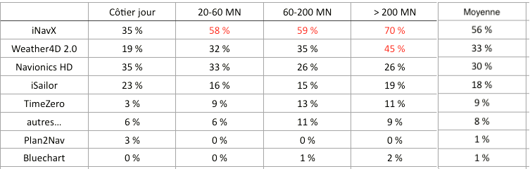
The predominance of iNavX is obvious, and even on par with Navionics HD in coastal navigation, what is surprising. Weather4D 2.0 has taken an important place on the tablets in few time, especially in the high seas. iSailor is still far from catching up iNavX.
However, When you know the sales figures provided by Navionics for its applications, It can be assumed that the largest share is sold to powerboating, its main target, whose followers are almost absent from this blog.
Number of applications used

Almost half of the boaters uses more than one application. This proves the trend to wear 'belt and braces '., for safety to have a choice between two different and/or additional charts. This is also explained by the relative low cost of applications and charts on tablets and smartphones.
———
(¹) http://www.developpement-durable.gouv.fr/IMG/pdf/plaisqqc2014b.pdf
(²) http://www.adt-herault.fr/docs/578-1-atout-france-le-marche-de-la-plaisance-en-france-pdf.pdf
(³) It is estimated the number of active boaters 2,1 million in 2015 (4% of French population + 15 years ago)
———
Hello,
Weather 4D 2.0 for the day but as soon as the nav is longer I me flaps on iNavX to be sure to have all the maps available.
In the future I hope I can no longer use weather 4 d 2.0 including the functions and the quality of the cards, more match my needs.
I use iSAILOR on iphone 5 from 2 years in addition and gradually replacing my lowrance GPSRouteur, I just spent on iSAILOR on Android, a little less friendly than on ios, but very precise, easy to use, and economic.
I use many different programs and softwares. I use MacENC, iNavX, OpenCPN and Charts and Tides for IOS. The later has only charts for US and Canada but integrates ActiveCaptain. iNavX is getting increasingly old and refuses to integrate AC data, or radar. Plus chart management is a nightmare with X Traverse.
Whoever comes to the table with world wide charts that auto update on a solid state device will reap great rewards.
I love Inavx, and weather 4 d . I am doing my routes on my side and my husband on his plotter of his, If the plotter goes down ( What is already happened) was the IPad in relief. This is handy. And ca deal ….
At anchor, I use the "Anchor" application, which uses less energy than the tracer on standby. I have the Navionics from Fugawi map for the Caribbean zone without problem.
I checked both iNavX and Weather4D 2.0 because so far, I haven't had much opportinuty to use Weather4D 2.0. I believe in the future, It will be Weather4D 2.0 for preparation and actual navigation close to coast. If I go beyond, lose Internet connection (via GSM) and therefore, cannot update the map, I would switch back to iNavX.
Cheers,
Dominique
Hello Francis. I use MacEnc on the mac as a basic tool and iNavX on ipad as a backup or for use outside.
I'm a little off words from your poll, but for my part, What is iPad or iPhone is a simple additional contribution to my main system, who is Coastal Explorer on a Panasonic Toughbook. I use the iPad (most often TimeZero) When I'm not at the helm and I want to check whether we still have the right course. And when I'm alone and I want to spend some time indoors, to prepare for eating or other, I plugged a GoPro on the front of the boat and can follow the images in real time on the iPad. It is not perfect, but it reassures, Since the AIS cannot read small craft. I sailed on the Great Lakes, in the Canada and United States.
Good idea with the GoPro.
How do you power the GoPro because the battery time is very short with Wifi
Bas
I prefer MacEnc on the Mac and iSailor on iPad and iphone. Navionics and iNavx are too complicated and more expensive. Navionics has such a clutterd website as well as such alot of different apps, which makes it complicate even to choose.
I mostly use MAC ENC. I love its simple interface. On my iPhone 6+, I use INavX with same raster maps (whew).
In the Caribbean, I use MacENC and app Navionix, because I have no maps that work with INavX. Weather 4 d pro is disappointing on I phone.
iNavX allows to use the Navionics 3XG via x-traverse map, for the Caribbean and South America, strictly identical to the Navionics Boating app. Actually, regardless of the application, an iPhone can only be a troubleshooting, view the size of its screen.
I am now using ISailor the most because of it’s interface and good visible charts.
I stopped working with INavx because of it’s complex charts system and interface
I use it together with Weather 4D prof for ideal routing.
Will there be a upgrade offer for Weather 4D prof user to upgrade to Weather 4D 2.0?
Kind regards
Bas Timmermans