

The relationship of a recent experience of an iNavX user and Weather4D PRO routing function invites me to bring a warning to the attention of novices boaters in computer use.
A regatta course, from St Helier (Jersey) to arrival Granville, optimized with Weather4D PRO using fine grid GCWF model and MyOcean currents prediction, gave the following route in iNavX :

The optimized route transferred to iNavX
The Southeasterly moderate wind and favorable current North East of Jersey traced a route through the rocky plateau offshore Jersey Southeast. When optimizing, it is apparent that the minimum distance constraint to the coast, defined as routing argument in Weather4D PRO, had kept its default 0 NM.

The optimized route runs on Violet Bank
It seems obvious that this route was not to be followed ! By looking more closely at the physical layout, an option by passing the Violet Channel allowed to join the favorable current leaving the plateau of Arconie starboard. But this required a good knowledge of the passage, the orientation of the current, and excellent visibility.
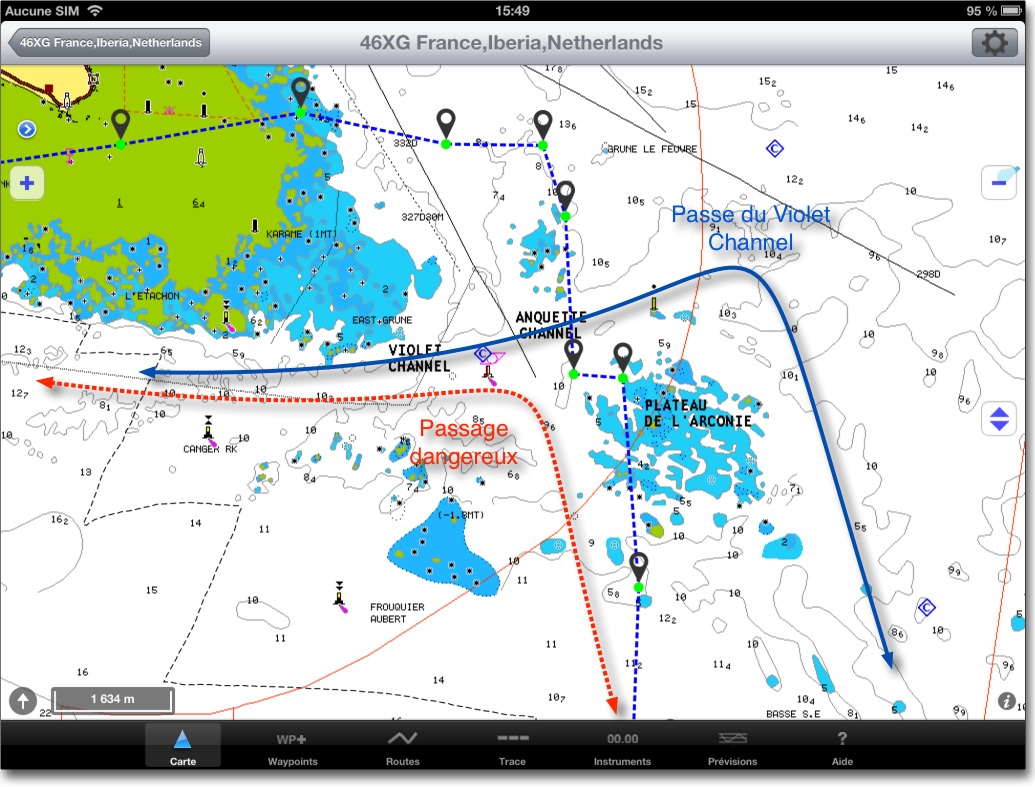
On screenshots above, we see the black dotted line track actually traveled by the sailor. This one, as an advised mariner, preferred to lose a few seats tacking healthy water rather than venturing into a tricky passage.
With the latest navigation applications associated with electronic charting, comfort provided should not overshadow the seamanship. As, contrary to appearances, one unknown part of imprecision is related to the implementation of these technologies.
Indeed, although the accuracy of the GPS system is indisputable, it is not necessarily the same for charting. ENCs are, mostly, reproductions of paper charts which lifted (hydrographic surveys) sometimes dating, in some areas, a time when the positioning means were much less accurate than today. On the other hand, reproductive technologies may be vitiated by error, as, in example, a bad datum conversion of original chart. Accordingly, if my position is accurate to within three meters, the rock outcropping focused on my PCB hundred meters from my position may well, actually, not lie only a few meters.
In coastal race, shave the stones is often tempting, but beware of the false security that brings a ship icon scrolling on an electronic chart, it will never replace good alignments checked in the landscape around the boat (*).
–––
(*) See About alignments and sextant
–––
Thank you for these few information. It is true that my starting point was the port of Bonifacio. I am also using the COAMPS forecast for Europe Module – Mediterranean. I have not yet signed registration Geat Circle, par contre j’ai constaté que lorsque Weather4D Pro affichait « importation réussie » sans la deuxième fenêtre en arrière plan mentionnant les modèles importés, le routage mentionnait systématiquement « erreur impossible de calculer le routage » La distance mini de la côté pour mon routage est laissée à zéro.
Again thank you for your help.
J’ai un « petit » soucis avec Weather4D Pro, after importing my way with iNavX, I run the routing Weather4D and an error message appears telling me that the routing has not been calculated. But without more information. It's been a while since I shop to see where the problem without finding a solution.
Can someone please help me ? and thank you in advance…
Mon mail : jeanchav@hotmail.com
This can come from causes plusiuers :
1. The waypoint is outside the forecast area.
2. The start time is earlier than the start of the forecast.
3. The waypoint is placed too close to the coast, the feature vector having a side accuracy of the order of 1000 meters. one GFS a 200 meters. en CWF. Attention au réglage de routage « Distance mini de la côte ».
Precision quality and weather routing information included in W4D pro.
A few days ago I saw that the weather that I downloaded with W4D in GCWF had nothing to do with the actual conditions at sea. I was able to share this with both Olivier Bouyssou the software developer and Gerald Bibot Great Circle.
I must say that this was the first time I noticed the gap doubled between lived reality and grib files loaded. The explanation is simple really and it seems good to clarify for anyone who might ignore. W4D The software takes into account the synoptic wind. It ignores bursts and, in this period of the Normandy Channel Race, it was served in the Channel. Olivier is currently working on a next MAJ that will integrate and wind gusts 925 mb. I do not know if this Update will be available to all or only to those who subscribed to the fine mesh subscription Great Circle ? I bet that when it will be available on frisera perfection with this great tool. In the meantime I'm enjoying the fact that my subscription by Great Circle W4D gives a right to the same period in the data set to cross the Belgian Site Info W4D with those Squid2. But then I know that I leave a little part of the site since Francis need a PC and internet on board….
I hope that this provides a more accurate users W4D and why not raise a comment advised Mr. Fustier
Mr. Fustier répond bien volontiers 🙂
I appreciate this interractivité between users and the developer, is also, I remember, either a. It is impossible for small testers, I am, to meet all the cases in navigation. Your feedback, those of John and a few others allow to move the application to the benefit of all. I would, repeating the song Michel Fugain : Bravo a merci !
Merci à Francis pour ces précisions pleines de bon sens « marin ».
It is true that advances in electronics could encourage marine forgetfulness of past practices. It would be a serious mistake. If for older browsers which I passed reflexes remain active, what about for beginners. It's good to draw attention to the fact. With all the material we can assure and secure its options taken. But as the runners are, active monitoring is essential and adaptation of the actual conditions encountered is relative with computer data. Nobody is perfect.
Very careful not to make a routing port of departure to port of arrival in these parts.
One solution would have been to make a preliminary route with two or three points of passage to avoid dangers. W4D Pro performs in these cases efficient routing and much more secure which shall not excuse the words of Francis verify the landscape