
I cannot resist the urge to show you some pics (*) to iNavX on iPad which has just crossed the Atlantic, from Mediterranean to Martinique. The sailor has abandoned his MacBook Air, on which he uses MacENC for several years with S-57 ENC charts. It switched to an iPad 3G, featured iNavX, Navionics Gold charts and the Apple app Numbers to write his log book.
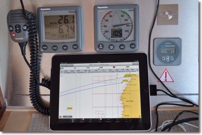
iNavX in action
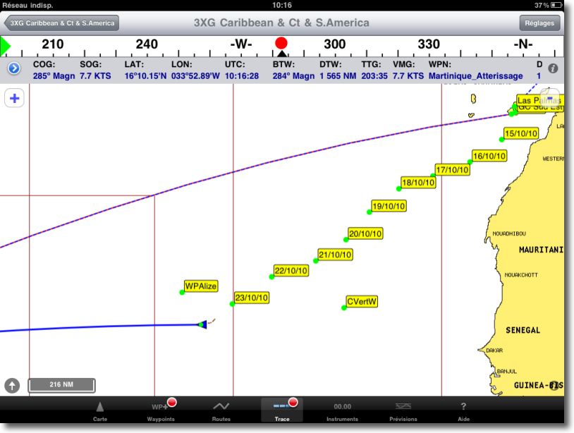
After the Canary Islands, WP are the points at Noon.
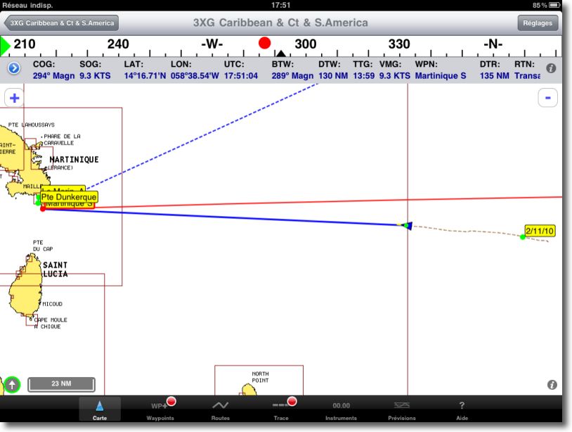
Last days before the Caribbean

Night approach…
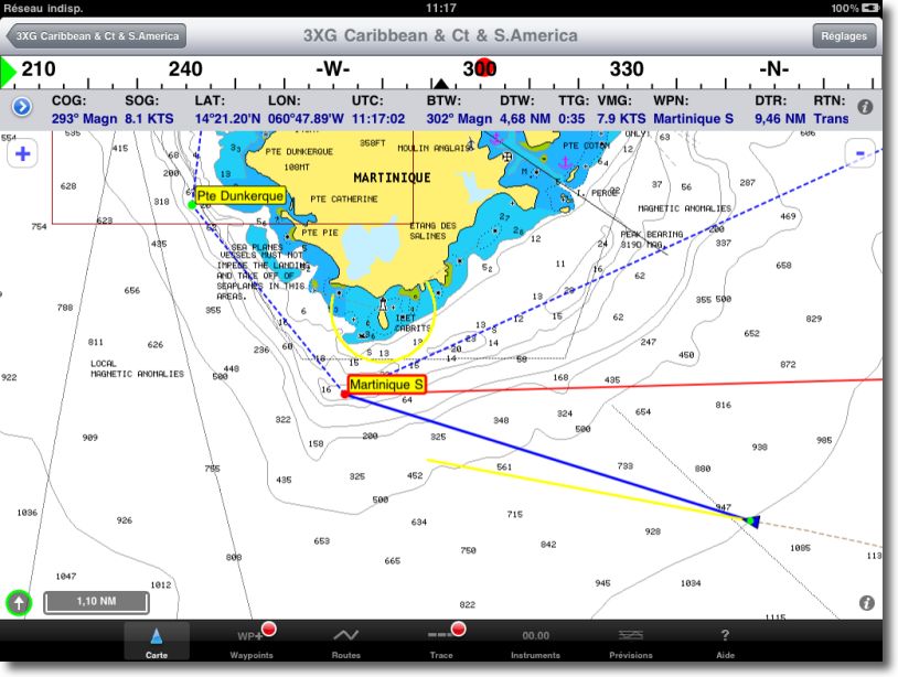
Last nautical miles…
For the skipper, This tablet is definitely adopted. There remains the problem of recovering GRIB files, Who, without ability of satellite connection in modem mode, is not yet possible. The GRIB are downloaded and displayed in the MacBook with MacENC.
Indeed, The phone Iridium offers a data kit for data download and the internet, but only through a USB cable. Moreover, The all-new IsatPhone Inmarsat offers a Bluetooth connection, but does not offer a data service.
We must therefore wait for the next iPad operating system, and an expected Apple opening to external devices connection, like GPS mentioned in a recent article.
Wait and see…
—
(*) Photo and screenshots courtesy of C. Mahé.
And yes am I stupid, but I didn't have iOS 4.2. Just one last thing, which has little to do with it, Rather anecdotal : in Cuba, I noticed a real discrepancy between my position on the iPad (and on a Raymarine plotter equipped with the same Navionics charts) and reality, a good thirty meters in the South-East. I didn't have any accurate enough ENC cards to check on MacEnc. Is it a Navionics error or rather a degradation of the GPS signal ? It should be noted that in Cuba GPS is in principle forbidden and satellite phones are banned and not only in principle.
For brightness, there is now with iOS 4.2.1 Accessible tuning (without closing applications) by double-clicking on the "Home" button, Swipe icons to the right, and the brightness slider appears next to iPod sound settings.
Good evening, The browser, This is me, I just added to this experience another crossing to Cuba, double-handed with a little wind. I confirm, the Ipad, it is super. But I also have a Mac Book, Mac Enc and Iridium. If Francis leaves this subject open and gives me some time, I'll get back to you to tell you more, if you are interested and once I have landed … See you again
Comments are open for 30 days after the article was published, or until 14 December. This article was quoted by Richard Ray On his Twitter page.
I really don't think using an iPad (on board a ship) or a fad. For me, it corresponds to the satisfaction of two essential needs :
-Good readability of information
-Mobility inside the boat depending on the circumstances.
These are the two defects of my Raymarine control unit, which on the other hand gives me complete satisfaction on the management of information. To replace the screen that is too small, you have to change the entire control unit at totally dissuasive prices!
The iPad with NMEA Multiplexer and WiFi seems to be MY solution. It must be said that my boat is a Fisher 37 with practical linkage when conditions are not good. I will obviously not put an iPad on the deck of a sportier sailboat !
I just read on the iNavx blog a response from the developer to Francis :
We will add an iMux configuration to the iNavX Guide in the next couple weeks. The iMux is going to allow iNavX to do something not possible before – send the NMEA-0183 data required to navigate to a waypoint to an autopilot. This will be in the next iNavX release.
This seems to me to be excellent news !
In addition, the iMUX (-from 200€ delivered)avoids the purchase of a WiFi multiplexer and transmitter (300 + 300 € !). Has anyone ever ordered an iMUX ?
About the iMux, I'm waiting for Richard Ray's configuration to make a presentation article. Moreover, I have in preparation an on-board test of the iPad with the different devices to centralize AIS data, Instruments, aso. This test will be carried out in collaboration with a nautical magazine in the course of next January.
This is a confirmation of my intuition of the qualities of the iPad when browsing with iNavX.
My boat is equipped with RayMarine whose screen is really difficult to read while sailing. I am seriously considering acquiring an iPad rather than switching to the new models whose prices are prohibitive. If the possibility of connecting to Wifi is limited, here is a real interactive nautical chart. It's a shame that there is no BLU decoding software for the Mac as on PCs.
Bonjour,
Of course, there are software for decoding BLU on Mac.
Personally, I use the free software : CocoaModem 2.
As for the iPad, contrary to what is written about the simple "fashion effect", there are several obvious advantages over the MAC.
* First of all, the price, whether it's the tablet itself, but also and above all on the mapping software and the mapping itself !
* Then, the absence of any mechanical parts (even if SSDs are now becoming more popular on laptops)
* Then consumption and autonomy
* Diet : from February the 12 Volts per simple cigarette lighter, No need for a converter 220 or small dedicated converter (especially since with the magsafe, The entry fee remains high, cf the MAXWAY solution)
* The touch interface : anyone who gets a taste of handling electronic cards on an iPad feels like they're going back to the Stone Age when they come back to a plotter or even a MacBook (Despite the fabulous trackpad of Apple's laptops).
* Mobility (it can easily be taken out on deck, It's more painful with a MacBook) even if it must then be put in a waterproof bag. The iPad is a great repeater.
As Francis said, Possible via wifi to connect to the on-board instruments via the ad hoc equipment (including for AIS).
Add to that the plethora of applications that are always useful on the go, and you have a rare versatility tool despite the legitimate preconceptions of the beginning.
I set off for two years around the Atlantic from 2011 to 2013 and the iPad will be part of the trip.
Useful add-on apps : GPS Motion X. I should also try HF Weather Fax with my SSB (decoding and displaying weather fax via SSB, in the manner of COCOA Modem mentioned above).
PS : iPad is not waterproof. Neither do most computers and I've never read this as a review. Especially since there are waterproof bags for the iPad while it's more delicate with a computer.
PS2 : the one and only weak point I see there today, it is the lack of possibility of interfacing it with such a satellite.
Looking forward to reading you.
Stéphane.
Bonjour,
I'm going to play devil's advocate…But what is the added value of an Ipad on a mac book??
The Ipad's connectors do not allow the possibility of a grib file, no AIS target, No instrument connection….Not to mention the size of the screen.
So if you need an iPad plus a MacBook…..
It seems to me that we are a bit of a fashion phenomenon, more than in a functional reality……
A + for +
Fashion phenomenon, No doubt ! But you are wrong on several points. iPad can receive GRIB files in iNavX, coastal navigation with a 3G connection, and at the stopover via WiFi.
Several devices today allow AIS data to be transferred via WiFi to the iPad that can be displayed with iNavX.
The 1024 display×768 from iPad, with iNavX and its new "full-screen" function is superior to most plotter readers.
There remains the problem of waterproofing, already mentioned on this blog.
For my own, I don't consider the iPad a gadget, but as a real alternative for small boats, and, Why not, a spare device for offshore navigation.
That being said, we can do without it perfectly !
Bonjour,
The advantage of the iPad lies above all in the price of the cards (200€ less on iPad for the 46XG map with a display and navigation comparable to a plotter or computer).
Bravo for the quality of the site.
Sincerely
Crossing the Atlantic with an iPad: Thank you for this very interesting information. This would tend to prove the reliability of this instrument. You talk about a logbook on Number.Je don't know much about this software ,Could you explain to me how your correspondent went about creating his logbook ?
Sincerely
Numbers is the spreadsheet program of Apple's office suite, an equivalent of Excel, somehow, and fully compatible with the latter. The iPad version is very similar, and allows you to enter text and numbers, and to make calculations. Imagine making a logbook on Excel sheets, it's the same.