
 The National Oceanic and Atmospheric Administration (NOAA) employs approximately 12 000 people around the world, more than half of whom are scientists and engineers. NOAA Operates 18 satellites and 15 vessels and has a budget of 6,8 billion dollars. Through various services, its job is to study the atmosphere (National Weather Service), study the oceans, fish resources, charting the seas (National Ocean Service), to follow their evolution and predict their future (Office of Oceanic and Atmospheric Research). NOAA's work is critical for aviation, Navy, fishing, climate research and offshore oil and gas exploration, especially when it comes to modelling weather patterns and climate change. Read more …
Author : Francis
From 2009 independent IT trainer and consultant for boating. Translator of several navigation apps on iOS and MacOS. Professional in boating for over 30 years old, I dispense from training to applications as well as advice and assistance for the integration of mobile devices (tablets, smartphones) on board pleasure boats.
iTabNav.fr gets a makeover
![]() You know all the good things I think of my partner and friend Dominique Gauthier, Founder and Managing Director of iTabNav.fr (¹). I have been using his products since the beginning, We frequently collaborate, and also sometimes sail together.
You know all the good things I think of my partner and friend Dominique Gauthier, Founder and Managing Director of iTabNav.fr (¹). I have been using his products since the beginning, We frequently collaborate, and also sometimes sail together.
He has just completed its online sales website a complete makeover. Read more …
5G in space : a very good news !
![]() The French satellite service provider Eutelsat has just announced on February 24 th that it has successfully completed the world's first test of connecting to the 5G non-terrestrial network using low-Earth orbit satellites (LEO) by OneWeb (¹).
The French satellite service provider Eutelsat has just announced on February 24 th that it has successfully completed the world's first test of connecting to the 5G non-terrestrial network using low-Earth orbit satellites (LEO) by OneWeb (¹).
This program not only addresses today's connectivity needs, but also lays the foundations for Europe's strategic autonomy in a digitalised world. ”
He said. Read more …
New tutorial : Weather in the Mediterranean
March, the volume 2 from Introduction to Marine Weather has been published on the iBook Store (Apple Books)

The Mediterranean Sea has a unique configuration in the world. An enclosed maritime area of nearly two thousand nautical miles from west to east, it is only open to the Atlantic by a strait of eight nautical miles. Read more …
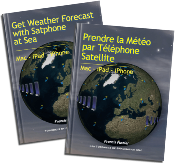
Get Weather Forecast with Satphone at Sea [Update V.2.2]
 Update 2.2 (February 2025)
- Get Weather Forecast with Satphone at Sea
- Get Weather forecast with Satphone at Sea.
-
- Updated pricing 2025.
- Starlink Services Update.
- Updated connection Go!exec® with Weather4D Routing & Navigation.
-
–––
Update Weather4D R&N 2.0.94
Update Weather4D 2.0.94 Fixing potential crashes of the application in certain conditions of use.
Updated also Weather4D Routage 2.0.59
–––
Mac Navigation in the Blue Sky
Navigation Mac is now on Blue Sky @navigationmac.bsky.social
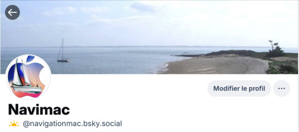
Definitive abandonment of X… Read more …
Celestial, navigation on iPhone and iPad [Update-2]
 [January update 2025] This great app, not updated for several years, no longer works and has been removed from the Apple Store. It's a shame because I had made the French version. A similar alternative could be Celestial Nav whose latest version 3.3 September date 2025, at the price of €30 for the PRO lifetime license. Compatible iOS 26.
`I haven't had the chance to test it yet.
___
SHOM map update at Geogarage
Catalog update SHOM charts France / DOM-TOM and dependencies by Geogarage for Weather4D Routage & Navigation and SailGrib WR
- 214 updated charts (dont 13 new editions)
- 4 deleted charts
The catalog includes 860 charts (1430 with insets)
–––
MacENCx64 V.10.2.0 Update
This important Updating the app mainly concerns the cartographic rendering of the user interface.
