 We've been talking about it since 2020 in the Facebook group of Weather4D users, the messaging app Weather4D Routage & Navigation (¹) now works on Mac with ARM processors : Mac M1 and later, from the system macOS 11.x (“Big Sur” et seq.). Simply connect the Mac to a GPS receiver or NMEA gateway via Wi-Fi to receive the position and navigation data of the instruments. Read more …
Label : Weather4D
Weather4D Routing User Guide
 New publication of Manuels to Weather4D Routage in French version. Warning, it is a new version to download which replaces the previous one (¹). The old guide should be removed from your library in the Apple Books app. Read more …
Weather4D Lite User Manual
 New publication of Manuels to Weather4D Lite in French version. Warning, it is a new version to download which replaces the previous one (¹). The old guide should be removed from your library in the Apple Books app. Read more …
Alternative weather models [Update]
[Update 29 July 2022]
For several years, forecast files in GRIB format have been widely used in meteorological applications.. The majority of forecast models have been made freely available by meteorological services, all countries included. Apps like XyGrib, LuckGrib, SailGrib, Weather4D and others, offer a selection of atmospheric and oceanic models, up to 60 Weather Models, Waves and currents for Weather4D, more than thirty models with LuckGrib, in example. But there are always others that can usefully complement the standard offerings of these applications. Read more …
Predict storms with Weather4D
 In Weather4D (all versions) most weather models provide a data called CAPE.
Convective Available Potential Energy, in French : Energie potentielle de convection disponible. Behind this obscure acronym hides a powerful storm forecasting tool. CAPE is measured in Joules per kilogram of air (J/Kg) and defines the vertical buoyancy energy of a hot air particle in a colder atmosphere. In other words, vertical acceleration of the air particle will be directly related to this energy measurement. Read more …
The Logbook in Weather4D Routing & Navigation
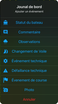 With update 2.0.57 Entering a logbook is now available in Weather4D Routing & Navigation. Data transfer to web interface Navygatio (¹) allows logbook entries to be recorded in near-real or delayed time depending on whether or not there is an internet connection during navigation. Read more …
Weather4D and iOS LAN
From iOS/iPadOS 14.5, A new setting has appeared proposing to allow applications to access the Local area network. This option is offered when installing a new application, but is not necessarily activated if the application is already installed when the OS is updated.
Since then, Many of you are no longer able to connect certain applications (Weather4D, iNavX, aso.) Wi-Fi-connected devices : Iridium GO!®, Multiplexers, Miscellaneous NMEA gateways. To do this, you must activate this "Local network" option for the application concerned. Read more …
Weather4D Routing User Guide & Navigation
 New publication of Manuels to Weather4D Routage & Navigation in French version. Warning, it is a new version to download which replaces the previous one (¹). The old guide should be removed from your library in the Apple Books app. Read more …
Navygatio : Weather4D's 5th dimension [Update]
Weather4D Routage & Navigation brings a major novelty : The Service Navygatio (¹), a web interface which will allow to record the navigations on a server as time goes by, add photos, to share own page with relatives, compare tracks, Analyze performance, and much more to come. A real " Cloud at the unique service of Weather4D Routage & Navigation users with iOS and SailGrib WR with Android. Read more …
Sea state : interpret wave patterns
In Weather4D, as generally in other applications, sea state forecasts are described by ocean models. The most used is the model WW3 (Wave Watch III), published by FNMOC (Fleet Numerical Meteorology and Oceanography Center) of the US Navy, with a global model due to 7 days and resolution 1° (60NM), and a Europe model to 3 days and resolution 0.2° (12NM). Météo-France publish the models MFAUM (Wave Assimilated Model) coupled with the ARPEGE and AROME weather models with three resolutions : Global at 0.5° (30NM), Europe at 0.1° (6NM), France at 0.025° (1,5NM) with variable deadlines (¹). Read more …

