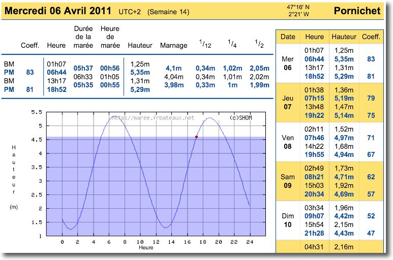
All navigation software offer predictions of tides, more or less long range, that cover the coasts of the whole world. Where come these predictions from ? How are they established ? What is their reliability ? These are all questions that any conscientious yachtman is entitled to ask.
Category : Applications
All applications
iPad 2 and iOS 4.3 – What's new for boaters ?
Since the introduction of this new iPad and installing the new OS on my devices (iPhone 3GS and iPad 1), I wondered about the advantages that could be derived from it by boaters, compared to previous model and system. Read more …
Crossing the Atlantic with an iPad
I cannot resist the urge to show you some pics (*) to iNavX on iPad which has just crossed the Atlantic, from Mediterranean to Martinique. The sailor has abandoned his MacBook Air, on which he uses MacENC for several years with S-57 ENC charts. It switched to an iPad 3G, featured iNavX, Navionics Gold charts and the Apple app Numbers to write his log book.

iNavX in action
Navionics Mobile and Community Sharing
Once will not hurt, I relayed the information in French from Blog Panbo which have interest for Apple mobile devices users.
Community Sharing
- User Generated Content (User-generated content)
- Social Mapping or Social Charting (Social Mapping)
- Crowd Sourcing (Crowd sourcing)
All these english words mean the same principle : sharing to the community all maritime information collected by each charting software user. In other words, each boater can use its navigation application to share all information on any changes observed over charts. This can concern the markup, the erection of a new quay or the appearance of new catways in a harbour, practical information on new harbourt services, incorrect positioning of a rock or the appearance of an uncharted shoal, etc,. Read more …
Marine weather on iPhone
In a previous post about my favorites apps for iPhone, I cited two weather apps : La Chaine Météo, very good general weather application from Meteo Consult, and iSailing Weather that offers maps of sea-based weather GRIB files from British origin.
Weather France has finally added its own free app, offering its full range of forecasts, including marine weather reports in text format. Read more …
AyeTides – World tides with iPad
AyeTides XL, tides prediction application of Hahn Software LLC, is available since 2 nd August on AppStore. Issue of the software AyeTides for Mac and AyeTides for iPhone, the iPad version offers a completely new user interface to take advantage of the size and definition of the screen.
With more than 12.500 tides and currents stations around the world, dont 160 stations in France, the app presents times and heights of tide level based on the US public software XTide (*) using harmonic data and tidal predictions from the National Ocean Service (NOAA). Numerous corrections have been made in order to obtain predictions with an average of less than 3% deviation from the predictions of official bodies, like the SHOM for France, and database updates are frequent and always free.
Read more …
MacENC 8 supports NMEA 2000
Richard Ray announced on the forum macsailing.net forum that great progress had been made on adding support NMEA 2000 in MacENC. MacENC 8 now use the Actisense NGT-1 USB gateway to connect your Mac to an N2K network (¹).
iNavX and iOS4
You are probably aware that the release of the new iOS4 operating system for iPhone and iPod Touch will be available today during the day, via synchronization of your (s) devices with iTunes. For the iPad, We will have to wait until the autumn.
About iNavX, Richard Ray has just written :
iOS 4 should be available tomorrow (21/06/2010). Only apps that are specifically built for iOS 4 will be able to take advantage of multitasking or toggle switching. iNavX 3.1.0 and later will support this feature.
Patience, therefore…
—
[Update September 01/07/2010] iNavX 3.1.0 is available on the AppStore.
iNavX 3.0.2 – highly expected new feature
INavX 3.0.2, available soon on the AppStore, comes with a much anticipated feature and welcome improvements :
Course Up / North Up
This feature, although criticized by some purists (of which I am part), was implemented to respond to numerous requests from users visiting the forum iphonesailing.net. Read more …
The stakeholders of electronic charting
Navionics charts, C-Map charts, BlueChart, MapMedia… You will admit that we have difficulty finding our way in all these brands of electronic cartography. Who belongs to whom ? What works with what ?
To help you see things more clearly, I took a little time to locate the main actors who, au final, provide us these wonderful charts that avoid storing pounds of paper. place free, and ecological in addition ! Once again, follow the leader… Read more …