
After my first post Crossing the Atlantic with an iPad here are some screenshots provided by Christophe Mahé between Panama and the Marquesas Islands, during his crossing last month. Just to dream a little, and to convince the last recalcitrant about the ability of an iPad to provide a position and trace a route anywhere on the globe. Read more …
Category : Charting
iSailor, charts are available for France
 Sex updated list of new charts available for iSailor, include coasts of France :
∙ Germany ∙ Australia ∙ Bermuda ∙ Canada ∙ Denmark ∙ Egypt ∙ Spain ∙ Estonia ∙ Finland ∙ France ∙ Greece ∙ Italy ∙ Ireland ∙ Latvia ∙ New Zealand ∙ Norway ∙ Papua New Guinea ∙ The Netherlands ∙ Portugal ∙ United Kingdom ∙ Suede ∙ USA : Atlantic Coast, Gulf Coast, Pacific Coast, Hawaiian Islands, Alaska, Great Lakes (U.S. Waters). Read more …
iSailor : Transas maps on iPhone and iPad
In France, mariners know little, or not at all, about Transas company of Russian origin. The Transas Group is nevertheless one of the world's leading professional of navigation software . Founded in 1990 in St Petersburgh, it opens its first office in England in Southampton (UK). Application developer for maritime and aeronautical training simulators, leading ECDIS certified designer, AIS network installer, the company has provided its electronic charting systems to prestigious customers, as the Russian space station MIR in 1996. There are countless marine simulator and flight simulators equipped with Transas technology in training centers worldwide. Several major commercial harbours are also equipped with VTS (*) and VTM (*) from Transas.
With 200 million turnover, the now international group, majority run by Russians, has its headquarters in Cork, Ireland.
All this to tell you that, when the very serious Transas company decides to launch a marine charting application on the iPhone and iPad, does not hesitate to rely on a communication, let’s say… particularly impactful. See instead… Read more …
Visit the bottom of the oceans
March, the NOAA has posted a superb animated digital mapping ocean bottom. A few thousand feet below our keel, this fantastic landscape leaves you dreaming. I can not help you to relay it with translation of their related comment. Read more …
About Marine Charting
Christmas is coming and, whether the celebration is religious or pagan, so traditional gifts.
You've no doubt guessed my passion for marine charting, but before electronic charts, I hold a special attachment to paper charts. I started sailing with SHOM charts in black and white, accompanied by pretty calligraphy engravings representing remarkable capes, alignments. Then appeared the colored charts, flat, difficult to store in a sailboat of 8 meters high. I bought charts from the British Admiralty, even more colourful, impossible formats, with complicated folding and cutting in the form of cartridges. Finally I discovered the West Indies charts Imray, of a reduced format, laminated and folded in protective plastic envelopes, a revolution on chart tables. Then SHOM also produces folded charts, "P" for Piacenza, that I sold for several years.
But this generally only represents the 35 Later years of marine charting.
I was therefore particularly fascinated by the two books that follow, maybe you already know because not recent, but which are really worth taking advantage of this festive period to be offered them, if you did not yet got. Read more …
Crossing the Atlantic with an iPad
I cannot resist the urge to show you some pics (*) to iNavX on iPad which has just crossed the Atlantic, from Mediterranean to Martinique. The sailor has abandoned his MacBook Air, on which he uses MacENC for several years with S-57 ENC charts. It switched to an iPad 3G, featured iNavX, Navionics Gold charts and the Apple app Numbers to write his log book.
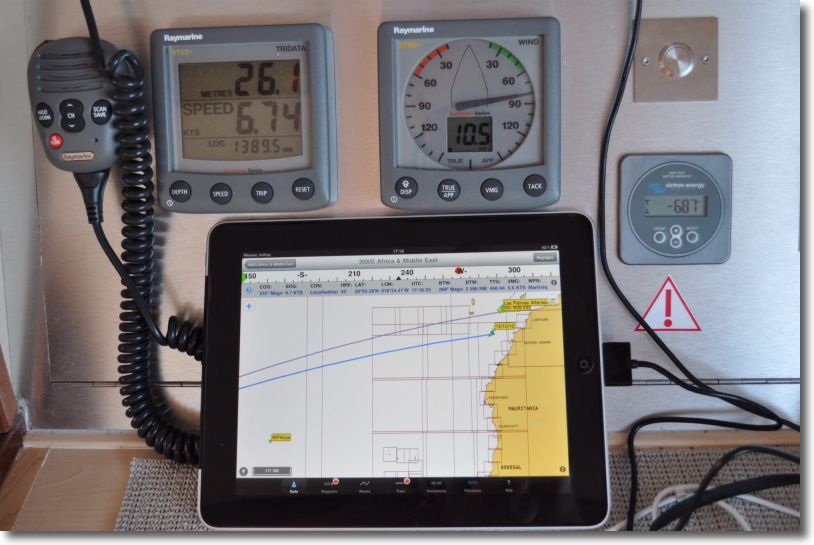
iNavX in action
View the currents on electronic charts ?
I deliberately title this article in the form of a question. Many users, all countries included, want the visualization of currents in Richard Ray's applications. Indeed, there is no display function of the currents in GPSNavX, MacENC and iNavX. It is a deliberate choice by the developer because there are many data sources and all hydrographic services are unwilling to provide their files in digital format. In addition, Users are likely to take data displayed on their cards as safe and certain, With consequences that could engage the liability of the publisher and legal risks, especially in the USA, too big for the developer. Read more …
Navionics Mobile and Community Sharing
Once will not hurt, I relayed the information in French from Blog Panbo which have interest for Apple mobile devices users.
Community Sharing
- User Generated Content (User-generated content)
- Social Mapping or Social Charting (Social Mapping)
- Crowd Sourcing (Crowd sourcing)
All these english words mean the same principle : sharing to the community all maritime information collected by each charting software user. In other words, each boater can use its navigation application to share all information on any changes observed over charts. This can concern the markup, the erection of a new quay or the appearance of new catways in a harbour, practical information on new harbourt services, incorrect positioning of a rock or the appearance of an uncharted shoal, aso. Read more …
The stakeholders of electronic charting
Navionics charts, C-Map charts, BlueChart, MapMedia… You will admit that we have difficulty finding our way in all these brands of electronic cartography. Who belongs to whom ? What works with what ?
To help you see things more clearly, I took a little time to locate the main actors who, au final, provide us these wonderful charts that avoid storing pounds of paper. place free, and ecological in addition ! Once again, follow the leader… Read more …
Print charts with GPSNavX / MacENC
These two applications offer direct printing of screen content. It is very convenient to print a chart, regardless of the scale used on the screen. Indeed, Print this concerns only the chart content visible on screen, excluding pop-up windows. As a general rule, you should first choose a landscape print format, and then use the menu File > Print.

Direct printing with GPSNavX