Update iNavX 5.0.7 [Update-2]

[Update] Following the update 5.0.6 the charts were again no more reachable. A release 5.0.7 delivered in the night of May 15 until 16 has solved the problem. But alas, the Fugawi/Chart website was made unavailable for a few hours, and therefore no more access to accounts to retrieve charts. Definitely, fate persists !

You can now resume the procedure :

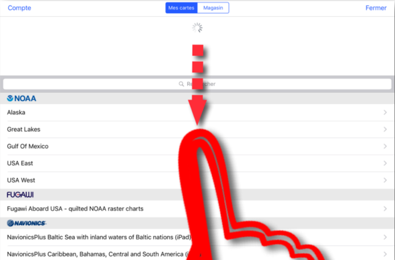
  1. Select the “Maps” page > “My cards” tab
  2. Select each chart folder you have purchased
  3. Type “Update Map List”
  4. Activate and download the folder again

To make it work, may be you need to logout/login to your Fugawi account. You will notice however that the French translation has been completed, at least one positive thing !

[Update-2]

To restore your cards in the “My cards” page, you have to pull the page down by sliding it with your finger, your purchases need to be refreshed.

–––

The new division of the NV Charts

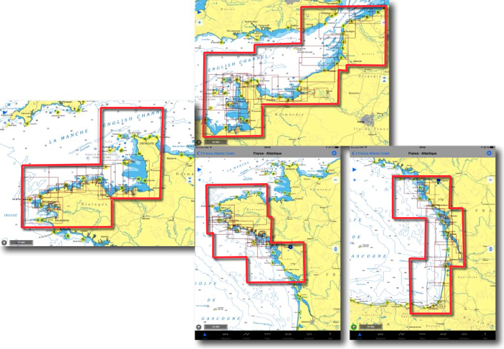
I had presented in May 2015 the excellent raster charts NV Charts by the German Publisher NV Verlag. In 2016, the previous cutting in 4 areas for France - Channel and Atlantic coasts - has been split into 8 areas for 49,90$ apiece. It should be noted that each year a new edition replaces the previous one, there is no update.

Bounderies in 2015

Read more …

Guide Escales 2017

I have mentioned last July the "Stopovers" Guide, digital version of Bloc Marine published by the Figaro Group. It seems that the remarks I made on the excessively fragmented division of these guides were heard : The version 2017 has the number of modules reduced by 17 down to 12 for the Channel-Atlantic coast, and 13 down to 10 for the Mediterranean. It is a welcome initiative !

Read more …

iNavX 5.0 from Charybde to Scylla

The major update 5.0 of iNavX, issued late August, was unfortunately a long and painful labor for new developers, and a succession of whirlpools and reefs for users. Among the many bugs and regressions laboriously fixed by successive builds, the worst part was the total loss of charts for almost all of us. This is, repeatedly. To top it all off the recent migration, this month, of charting server X-Traverse to a new website Fugawi much more user-friendly, didn't make things easy. Some explanations are necessary. Read more …

The Weather4D 2.0 new is arrived

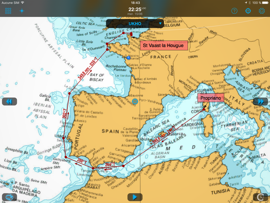
No developer vacations ! I talked about testing the new features to come during our Long journey from Corsica to Normandy last May. After several weeks of finalization, and mainly to adapt early to future iOS 10 Available this fall, here is the delivery of the new version 2.0.15 in Weather4D 2.0. An addition of long-awaited new features.
Read more …

stairs – the digital version of Bloc Marine

At the beginning of this year I wrote the greatest good I thought of the Digital Almanac, the digitized version of Reed’s Nautical Almanac. The Figaro group, Publisher of the website www.figaronautisme.fr, owner of Météo-Consult / The Weather Channel and Logbook – Marine Block, Published since the end 2014 "Stopover Guides", the digitized version of the Marine Block on the iBook Store. Read more …

Roseanor, 2000 nautical miles against the grain around Europe

Conveying a boat from Corsica to Normandy in May, it's a bit like going around the world upside down from East to West, but more modest. Two thousands nautical miles on the water against winds and tides, four and a half weeks at sea, with thirteen days forced stopover awaiting for good weather conditions, three hundreds and fifty hours of engine to support the sails, 1000 litres of diesel oil, multiple Corsican, Spanish and Portuguese wines bibs, to calm our nerves, A few packs of water to quench thirst, and hundreds of hours of testing the new features in development of… Weather4D Routage & Navigation !

Read more …

Navionics Boating 9.0 update on what's new

Updated on 17 May, Navionics Boating presents some modifications, in presentation and functionalities.

First of all only subsist Navionics Boating for iPhone and "Boating HD" » for iPad. The old names have disappeared, happily because confusion was great. Version purchased with built-in charting has the name of the region, for example "Europe HD" for iPad. On the other hand, there is a free version called "Seas and Lakes" which allows to test then buy a chart of the area of choice, and additional options. Read more …

Weather4D 2.0.11 A bunch of new features and improvements

Delivered in AppStore this morning after two weeks of revisions and contre-revisions of Apple services, Always more picky, The new version is finally available. On the menu and in bulk : AIS via internet with AISHub, direct access to Geogarage and cache memory chart management, new model of GRIB weather forecast from Meteo-France AROME HD for inshore races, Full-screen mode, advanced distance calculations, the most visible. Under the hood also a lot of optimization for routing and power consumption. Detailed review to follow… Read more …

C-Map back to Europe

Yachtmen my friends, do you know Altor ? Of course not, don't look for, me either until this morning. Altor is an investor from northern Europe who presents himself as follows :

"Altor is a family of Private Equity Funds focused on investing in and developing and medium sized companies with’a Nordic origin. We want to create Sustainable values and make a real difference as a a valuable partner For Owners and managers in buiding to world class companies. We work with a Nordic team with extensive international experience in fields such as private equity, consulting, investment banking and various industrial sectors."

But why talk about it ? Read more …