
![]() Since the release of Iridium GO! (¹) There were two different pages of subscription (for free) to messaging service, and two applications (iOS/Android) to connect to Iridium devices. Now there is only one application : Iridium Mail & Web app to connect to either the router Optimizer, or to Iridium GO! Read more …
Since the release of Iridium GO! (¹) There were two different pages of subscription (for free) to messaging service, and two applications (iOS/Android) to connect to Iridium devices. Now there is only one application : Iridium Mail & Web app to connect to either the router Optimizer, or to Iridium GO! Read more …
Iridium GO! keeps its promises [Update]
Since its announcement last February, and GO! took a long time to arrive at retailers until the beginning of this month. The company E-SAT gave me one to conduct some tests. Although too late to carry out these tests at sea, the Quai des Antilles on the Ile de Nantes offers a wide sky clearance also than the deck of a boat, enough to connect satellites of all-round. Two types of tests were carried out : requests and receipts of GRIB weather files from an iPad featured with Weather4D PRO app, functions related to telephony from an iPhone.

Routing and usage precautions
With the advent of powerful weather-routing applications on our tablets and smartphones, as Weather4D and SailGrib WR, at truly affordable prices, routing is becoming more popular for pleasure boating. The quality of these applications is already appealing to amateur sailors, and even some high-seas professional riders, but also a growing number of leisure boaters. Riders use the routing in the essential interests of performance, Achieve the fastest route from one point to another, so leisure boaters are more focused on getting safer and more comfortable routes. For them, The notion of speed is mainly used to avoid periods of bad weather, and the optimized route to escape areas where sea and wind conditions can be dangerous. Routing is also used for this : even in powerboating, you may try to avoid too much wind speeds or wave heights to ensure ypur crew comfortable and serene trip. But what credibility can be given to routing ? Read more …
IsatPhone 2 the new satellite phone from Inmarsat [Update-2]
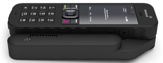 The war is open between the two leading operators worldwide satellite phone. After the announcement of the GO! by Iridium (¹), here is IsatPhone 2 by Inmarsat.
Inmarsat will deliver its new mobile satellite phone on March 24 next. IsatPhone 2 Targets the high-end of the satellite telephony market. Described as "a fine device combined with a feeling of high quality", it has additional options and more features than the previous IsatPhone Pro model (²), such as GPS tracking, an emergency button or the reception of calls with the antenna folded. Read more …
Plea for free European data
This could be a subject of the Baccalaureate in Economic Sciences, and although I never took this exam (because of post-68 incompatibility and Cancerism chronic) The subject seems to me sufficiently imminent and serious to attempt to deal with it, from my modest point of view. Read more …
iPadNav.fr becomes iTabNav.fr
![]() March, the 14 th 2011 I had announce the opening of an e-commerce website focused in accessories, mounts and connexion devices dedicated to iPhone and iPad for marine navigation : iPadNav.fr. Since then, its founder and I maintained a close collaboration, our complementary actions allowing us to provide an effective response to all new users of these wonderful tools perfectly suited to nautical activities. Many of you were able to meet me several times on his stand, both the Grand Pavois de La Rochelle and the Paris Nautic boat show.
March, the 14 th 2011 I had announce the opening of an e-commerce website focused in accessories, mounts and connexion devices dedicated to iPhone and iPad for marine navigation : iPadNav.fr. Since then, its founder and I maintained a close collaboration, our complementary actions allowing us to provide an effective response to all new users of these wonderful tools perfectly suited to nautical activities. Many of you were able to meet me several times on his stand, both the Grand Pavois de La Rochelle and the Paris Nautic boat show.
After three years of existence, Dominique Gauthier company has grown considerably, to the point of wanting to expand its offering to users other than boating : outdoor sports, hiking, trekking, fitness, and all leisure activities for which numerous targeted applications are now available, both for Apple devices and for the fast-growing market for Android devices.
Thus, iPadNav has just announced in a press release the change of name of its website to iTabNav.fr July 1st 2014, in a desire to open his offers to all useful accessories for tablets and smartphones, regardless of brand or operating system, and for all leisure activities.
Hope that this new extended offering meet the same success as for leisure boating and sailing, because iTabNav.fr will offer specialized products scattered across multiple foreign websites on a single French website. With local French service and support as a bonus.
With IsatHub, Inmarsat promises to connect - much - faster [Update]
 After the announcement with great pump of the GO! by Iridium few month ago, but not yet available, Inmarsat has introduced IsatHub at CommunicAsia show which just closed its doors in Singapur. The competition is tough between the two industrial, but unlike Iridium more oriented towards mainstream users, Inmarsat is aimed primarily at a professional market.
IsatHub is a WiFi hotspot allowing to connect all mobile devices to Inmarsat satellite network. No need cellular towers, IsatHub provides aworldwide connectivity to your tablets and smartphones.
Read more …
A RADAR screen finally on iPad
![]()
 Done ! Furuno annouced on 7 th 2014 until Stockholm Boatshow his new radar DRS4W – W comes for WiFi – allowing display on iPad and iPhone. Would be available in May in France. The relevant application DRS4W is available for free on all AppStores.
DRS4W is the first radar that features WiFi to, finally, change iPhone and iPad in a real radar display. After satphones connection, Here are the last bastion of marine electronics that falls. More exactly, a leader in marine electronics finally takes into account the irreversible evolution of consumer technology. Read more …
iPad GPS far away from networks
For those who do are not yet fully convinced, despite my assertions in many posts (¹), Here's another example of the accuracy of iPad GPS, cut off from any cellular or terrestrial Wi-Fi network. Already lived in 2011 during a stay in La Reunion (²), this time back from a recent trip to London I brought back the "proofs" below, screenshoted aboard an Airbus A320 : Read more …
Electronic charts : scales and overscale [Update]
A recent email exchange with a Mediterranean user drew my attention to a specific aspect of electronic charting : zoom limitation of a chart. ENC vector charts (¹) are classified in 6 categories depending scale : smallest scales less than 1:1.500.000 for global views to largest scale up to 1:4.000 for harbours and anchorages. (²).

Marine charts international classification
In most cases, ENC S-57 (¹) official charts the most detailed have a scale about 1:4000, thus 1 cm on the chart (screen view) represent 40 meters on the ground. With paper chart, the only way to get more details is… to use a a magnifying glass, that provides, as we know, in no case more accuracy. But it is quite otherwise for electronics charts.