 Weather4D 2.0 is available sur Apple AppStore (*). After the success of the first two versions, APP4NAV company just revisit chart navigation on iPad and iPhone by integrating the timing dimension. With simulations and weather routing, navigation becomes predictive, allowing a constant anticipation of future weather conditions and sea state. This “navigation into the future”, relied on the quality of meteorological and oceanographic predictions today available, was designed in order to bring a new dimension to the safety of boaters. Read more …
Label : GRIB
Météo-France GRIB files finally for free
 A year after my advocacy for free European data (¹) Météo-France finally offers free access to its two famous ARPEGE and AROME models. A welcome development, started in 2014 by the success of MyOcean, since then integrated into Mercator Ocean (²), but a notable change of attitude for a public establishment which has always been asked to self-finance a significant part of its budget. Forecasts from these two models are made available on Météo-France portal in the GRIB version 2 format. Since the 21 July 2015.
New GFS grid 0.25° model
 By a corrected notification on 23 December 2014 (¹), with NWS (National Weather Service) NOAA announced a major update to its GFS weather prediction model to be effective in mid-January 2015. Actually, This model has been partially available on an experimental basis since the beginning of December.
NOTE
March, the Global Forecast System (GFS) is a weather forecasting model produced by the National Centers for Environmental Prediction (NCEP) dependent on the NWS. Dozens of variables (²) are available through this dataset, from the temperatures, winds and precipitation down to soil moisture and atmospheric ozone concentration. The entire world is covered by the current GFS model with a horizontal resolution of 27 km between grid points up to 10 days. The horizontal resolution is 70 km for forecasts between one week and two weeks. The GFS model is a coupled model, Composed of four distinct models (An atmospheric model, An ocean model, A terrestrial model, and a sea ice model), that compete together to give an accurate picture of weather conditions. Changes are regularly made to the GFS model to improve the performance and accuracy of the forecasts. Mesh data is available for download via NOMADS servers (National Operational Model Archive and Distribution System) and widely used by app developers around the world.
Read more …
Iridium Mail & Web became fully usable again
 Since release Apple iOS 8 early October 2014 the messaging app Iridium Mail & Web app (who replaced Iridium Mail & Web app) was no longer able to export an attachment to another application using the “Open in” function.… ”. As a result, a GRIB weather file received as an attachment from the SailDocs server could no longer be used in any application, mainly Weather4D PRO.
It took more than 3 months for two successive updates to correct this severely handicapping problem for Iridium customer users :
Iridium GO! keeps its promises [Update]
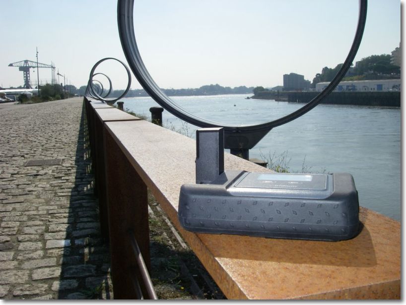
Since its announcement last February, and GO! took a long time to arrive at retailers until the beginning of this month. The company E-SAT gave me one to conduct some tests. Although too late to carry out these tests at sea, the Quai des Antilles on the Ile de Nantes offers a wide sky clearance also than the deck of a boat, enough to connect satellites of all-round. Two types of tests were carried out : requests and receipts of GRIB weather files from an iPad featured with Weather4D PRO app, functions related to telephony from an iPhone.
Routing and usage precautions
With the advent of powerful weather-routing applications on our tablets and smartphones, as Weather4D and SailGrib WR, at truly affordable prices, routing is becoming more popular for pleasure boating. The quality of these applications is already appealing to amateur sailors, and even some high-seas professional riders, but also a growing number of leisure boaters. Riders use the routing in the essential interests of performance, Achieve the fastest route from one point to another, so leisure boaters are more focused on getting safer and more comfortable routes. For them, The notion of speed is mainly used to avoid periods of bad weather, and the optimized route to escape areas where sea and wind conditions can be dangerous. Routing is also used for this : even in powerboating, you may try to avoid too much wind speeds or wave heights to ensure ypur crew comfortable and serene trip. But what credibility can be given to routing ? Read more …
IsatPhone 2 the new satellite phone from Inmarsat [Update-2]
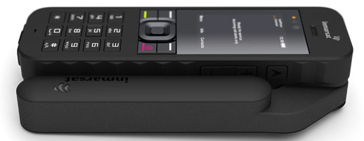 The war is open between the two leading operators worldwide satellite phone. After the announcement of the GO! by Iridium (¹), here is IsatPhone 2 by Inmarsat.
Inmarsat will deliver its new mobile satellite phone on March 24 next. IsatPhone 2 Targets the high-end of the satellite telephony market. Described as "a fine device combined with a feeling of high quality", it has additional options and more features than the previous IsatPhone Pro model (²), such as GPS tracking, an emergency button or the reception of calls with the antenna folded. Read more …
Weather4D still makes greater finesse
 With the basic 1.3.3 and PRO versions 1.3.9 delivered last November, Weather4D had replaced the GRIB files fine grid from Great Circle by its own files based on the U.S. model WRF (¹), computed under his own steam. These files cover Europe, Greece, Canaria, Azores, Greater and Lesser Antilles, offer a resolution of 0.1° (6 NM) up to 96 hours by 1 hour steps. The data provided is the same as the GFS model (¹). At the same time, The annual subscription price has been reduced by 60 down to 30 €.
Thanks to the implementation of new means, the next updates that have just been submitted to Apple Store will provide even more details. Olivier Bouyssou explains :
« FYI, App4Nav uses 6 different servers, 2 for the calculation of WRF model and 4 for distributing GRIBs : 2 for the US+Asia region and 2 for Europe. At this time 8000 GRIBs are distributed per day and triple during the season… ”
This now enables to provide, for the French coasts, including Corsica, ultra-fine grid to 0.04 °, that to say 2,4 NM. It also adds to the GFS and WRF files new data evaluating wind gusts. Read more …
Weather4D PRO 1.3.3 further improves routing
 Improvements…
No respite for this application : two and a half months after integrating the currents into the routing calculation, this latest version provides significant advances on this function. The improvements bring greater precision to the calculation of the optimized route and new parameters allow for fine-tuning.
… and two pieces of good news :
They concern currents, follow the leader… Read more …
iNavX 3.6.1 with high-resolution GRIB files
Since version 3.6.1 iNavX provides overlay of GRIB weather files in high resolution from theyr.com. This English website owned by Kona Ltd company is the developer of the application GribView which I talked about in a previous post (¹). An active account on x-traverse.com must be open, and done subscription to one of the Theyr subscriptions.
Actually x-traverse.com website allows two subscriptions :
- Theyr Standard – Mobile at the annual price of $9,99 (environ 7,85 €) or monthly of $3,99 (environ 3,10 €)
- Theyr Premium – Mobile at the annual price of $19,99 (environ 15,70 €) or monthly of $6,99 (environ 5,40 €)


