
![]() Delivered in AppStore this morning after two weeks of revisions and contre-revisions of Apple services, Always more picky, The new version is finally available. On the menu and in bulk : AIS via internet with AISHub, direct access to Geogarage and cache memory chart management, new model of GRIB weather forecast from Meteo-France AROME HD for inshore races, Full-screen mode, advanced distance calculations, the most visible. Under the hood also a lot of optimization for routing and power consumption. Detailed review to follow… Read more …
Delivered in AppStore this morning after two weeks of revisions and contre-revisions of Apple services, Always more picky, The new version is finally available. On the menu and in bulk : AIS via internet with AISHub, direct access to Geogarage and cache memory chart management, new model of GRIB weather forecast from Meteo-France AROME HD for inshore races, Full-screen mode, advanced distance calculations, the most visible. Under the hood also a lot of optimization for routing and power consumption. Detailed review to follow… Read more …
Category : Tutorials
How to…
Buy nautical charts on Geogarage
![]() Weather4D Routage & Navigation offers a choice of raster charts from many international hydrographic services . Charts folders are available for application on the French web server Geogarage. Charts are subject to an annual subscription by Publisher directly on Geogarage website after creating an account there. After subscribing to a publisher, the entry in Weather4D 2.0 credentials created in Geogarage activate display of subscribed folder , ready to download. Procedure step-by-step :
Weather4D Routage & Navigation offers a choice of raster charts from many international hydrographic services . Charts folders are available for application on the French web server Geogarage. Charts are subject to an annual subscription by Publisher directly on Geogarage website after creating an account there. After subscribing to a publisher, the entry in Weather4D 2.0 credentials created in Geogarage activate display of subscribed folder , ready to download. Procedure step-by-step :
Weather4D 2.0 revisits navigation on iPad [Update]
![]() Weather4D 2.0 is available sur Apple AppStore (*). After the success of the first two versions, APP4NAV company just revisit chart navigation on iPad and iPhone by integrating the timing dimension. With simulations and weather routing, navigation becomes predictive, allowing a constant anticipation of future weather conditions and sea state. This “navigation into the future”, relied on the quality of meteorological and oceanographic predictions today available, was designed in order to bring a new dimension to the safety of boaters. Read more …
Weather4D 2.0 is available sur Apple AppStore (*). After the success of the first two versions, APP4NAV company just revisit chart navigation on iPad and iPhone by integrating the timing dimension. With simulations and weather routing, navigation becomes predictive, allowing a constant anticipation of future weather conditions and sea state. This “navigation into the future”, relied on the quality of meteorological and oceanographic predictions today available, was designed in order to bring a new dimension to the safety of boaters. Read more …
AIS reception on the web [Update]
 In recent years, websites allowing the visualization of maritime traffic have developed on the web.. They continuously transmit via the internet the positions received from the ships' AIS transmitters, received by reception bases on land, all along the coasts. Two of them caught my attention because they present very different options : Marine Traffic et SiiTech. Read more …
Signal K Project, universal open source marine data sharing
You will soon hear about Signal K, a marine data communication standard, developed in open source, which aims to replace NMEA standards (0183 and 2000) technically overwhelmed by the exponential development of connected objects. The designers intend to provide an open and free protocol to developers and manufacturers alike., allowing to get over the constraints linked to the NMEA : license costs, flow limits, limit the number and type of devices, unsuitability for complex environments, to wireless communications, therefore incompatible with the Internet of Things and the Internet itself.

AIS for dummies
With the progressive generalization of the AIS (transceivers) aboard our pleasure boats (¹), and their obligatory presence on board a large proportion of commercial ships, capacities for display and processing of targets (surrounding vessels equipped with a transceiver) have significantly improved our security. Still need to know how to interpret this information that, in high-traffic areas, can quickly become a real headache.
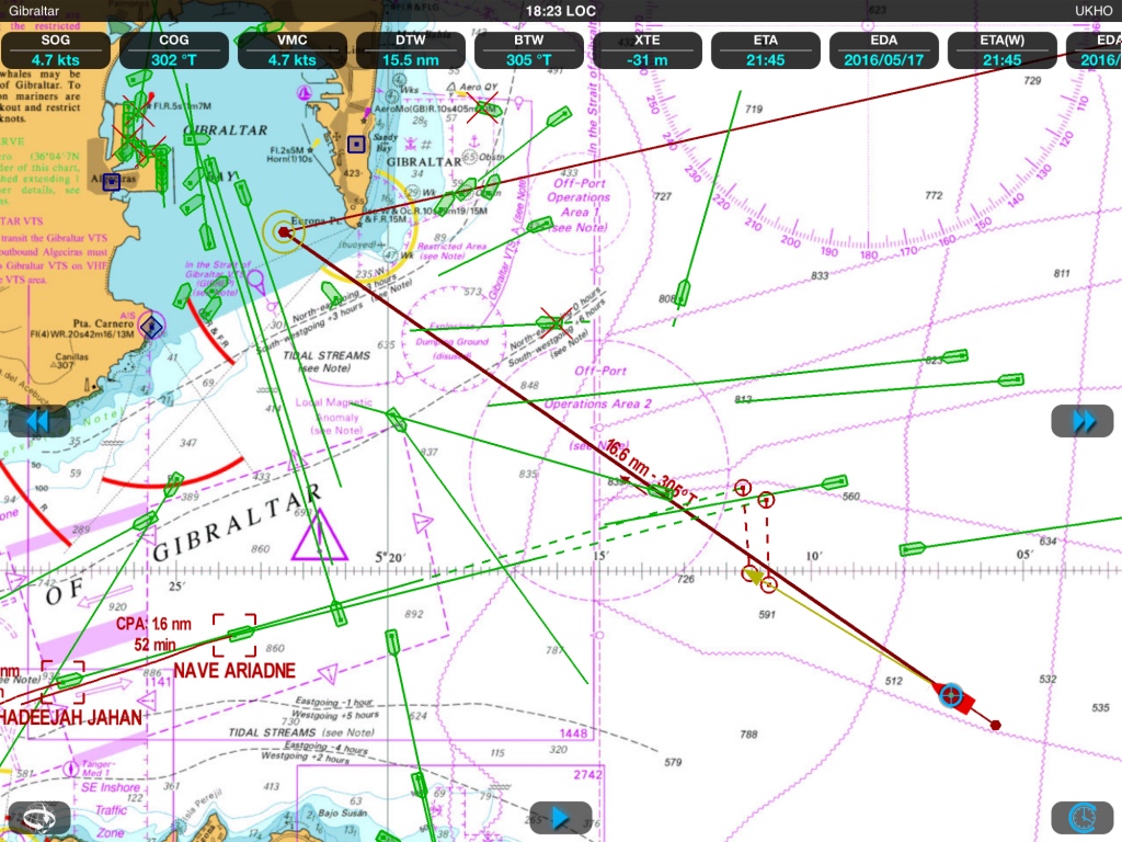
In such a situation, better have a quick diagnosis of the risk of collision ! (Weather4D 2.0)
iNavX undergoes a change of ownership
![]() New developers, new logo, new splash page, and new website.
New developers, new logo, new splash page, and new website.
The version 4.7.0 has just been delivered by NavX Studios LLC, the company that bought all of Richard Ray's computer creations : GPSNavX, MacENC and iNavX.
The handover took place during the summer. New developers (there are two of them) were first focused on iNavX, for a first debugging update, performance optimization and acceleration of charts downloading with X-Traverse. We can bet that this transfer will bring a new dynamic to these excellent applications, whose creation and development have rested since 2002 on the unique Rich Ray's keyboard.
I continue to test and produce the French version of these applications on behalf of the new team.
Use your iPhone as a GPS for iPad Wi-Fi
 With the appGPS2IP, we can use (temporaly) the GPS of an iPhone to transmit the position to a Wi-Fi iPad that does not have GPS.
But this method should only be seen as a temporary repair for the reasons which will be mentioned later.. NMEA position data will be sent by GPS2IP using TCP/IP protocol through cellular tethering.
NV Chart extends coasts of France from SHOM
In a previous entry I presented the SHOM raster charts provided by many publishers on iPad. For several weeks the German nautical chart publisher NV Verlag offers two new areas ending coverage of the coasts of France Atlantic and English Channel. These charts are usable both with iNavX on iPad/iPhone, only with GPSNavX and MacENC on Mac. We can therefore, unlike Navionics, use the two available copies of each region on two different media (iPad , iPhone ou Mac).

iNavX and iSailor always offer more functions
The year 2015 barely started, the developers are already giving us the developments of their applications, probably made between two glasses of champagne during the holidays. I consider iNavX and iSailor as the two best navigation apps so far under iOS. These are the ones that offer the most extensive functions and the selection of the best charts. They each have their qualities and faults., and I take advantage of the new features brought by their recent update to try a quick function/price comparison.
Warning, this exercise is associated with a snapshot vision, valid today but quickly obsolete tomorrow, as changes are rapid in this domain. On the other hand, it is always difficult to distinguish between objective and subjective aspects in a comparison., I was already confronted in the past (¹). Read more …