The least I can say, it’s that the new things don’t jostle. After the frenzy of announcements of 2013, the developers seem to be marking time. It is likely that the proliferation of navigation apps should not promote their profitability, and that the financial return on investment in development and maintenance time should not be obtained by everyone. Navionics charts remains the undisputed leader. By creating its new “Boating” formula to complement and/or replace “Marine” (¹) it revives sales which were probably starting to run out of steam. iNavX remains the best-selling independent application in the USA, and the rest of the world through combination with Navionics cartography, and particularly in France thanks… to the strong promotion to which I contribute. Its developer multiplies very regular updates, which ensures good positioning on the AppStore and user satisfaction, despite the questionable ergonomics of certain functions. Read more …
Category : Tutorials
How to…
iNavX 4.0.0 improves charting [Update]
 iNavX 4.0.0 greatly improves the display of raster charts : continuous seamless tiled charts (¹) and access to a new Navionics Gold chart : the 50XG covering almost the entire Pacific Ocean. Read more …
Weather4D still makes greater finesse
 With the basic 1.3.3 and PRO versions 1.3.9 delivered last November, Weather4D had replaced the GRIB files fine grid from Great Circle by its own files based on the U.S. model WRF (¹), computed under his own steam. These files cover Europe, Greece, Canaria, Azores, Greater and Lesser Antilles, offer a resolution of 0.1° (6 NM) up to 96 hours by 1 hour steps. The data provided is the same as the GFS model (¹). At the same time, The annual subscription price has been reduced by 60 down to 30 €.
Thanks to the implementation of new means, the next updates that have just been submitted to Apple Store will provide even more details. Olivier Bouyssou explains :
« FYI, App4Nav uses 6 different servers, 2 for the calculation of WRF model and 4 for distributing GRIBs : 2 for the US+Asia region and 2 for Europe. At this time 8000 GRIBs are distributed per day and triple during the season… ”
This now enables to provide, for the French coasts, including Corsica, ultra-fine grid to 0.04 °, that to say 2,4 NM. It also adds to the GFS and WRF files new data evaluating wind gusts. Read more …
ENCs, Routing and sailing shaves stone
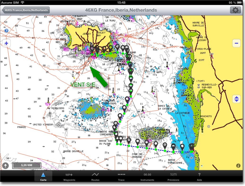
The relationship of a recent experience of an iNavX user and Weather4D PRO routing function invites me to bring a warning to the attention of novices boaters in computer use.
A regatta course, departure from St Helier (Jersey) to arrival Granville, optimized with Weather4D PRO using fine grid GCWF model and MyOcean currents prediction, gave the following route in iNavX :
Weather4D PRO 1.3.3 further improves routing
 Improvements…
No respite for this application : two and a half months after integrating the currents into the routing calculation, this latest version provides significant advances on this function. The improvements bring greater precision to the calculation of the optimized route and new parameters allow for fine-tuning.
… and two pieces of good news :
They concern currents, follow the leader… Read more …
Install a WiFi network onboard
Request more frequent from boat owners is for the installation of a WiFi reception onboard. The proliferation of computers, tablets and smartphones on boats incentive to maintain a connection with the Internet, even while sailing. Exchange emails, Follow social media, Receive weather files, and how many other reasons lead to an irrepressible addiction. C’est la vie !
I have already mentioned on my website, in chapter about means for receiving GRIB files, some available solutions : Read more …
Weather4D PRO 1.3.2 adds the currents in the routing
 With the version 1.3.2, Weather4D PRO allows to get and display currents as GRIB data. To begin with, currents available are provided with subscription by Tidetech, I mentioned there in the past (¹). Once entered in Weather4D PRO settings a username and password, provided at the time of subscription, you can access Tidetech global catalog.
Only one PRO subscription to Tidetech allows you to obtain files in GRIB format. The company is considering a specific offer for applications on iPad / iPhone. Read more …
iPolar generates speed polars for Weather4D PRO
 You dreamed of it since Weather4D Pro has featured its powerful routing module. He did it !
Our Toulousian crazy developer, Olivier Bouyssou, just sent Apple a new app : iPolar.
Developed in collaboration with — and on behalf of — KND SailingPerformance, iPolar calculates the performance polars of a sailboat based on specific parameters, Easy to identify : Read more …
iNavX 3.6.1 with high-resolution GRIB files
Since version 3.6.1 iNavX provides overlay of GRIB weather files in high resolution from theyr.com. This English website owned by Kona Ltd company is the developer of the application GribView which I talked about in a previous post (¹). An active account on x-traverse.com must be open, and done subscription to one of the Theyr subscriptions.
Actually x-traverse.com website allows two subscriptions :
- Theyr Standard – Mobile at the annual price of $9,99 (environ 7,85 €) or monthly of $3,99 (environ 3,10 €)
- Theyr Premium – Mobile at the annual price of $19,99 (environ 15,70 €) or monthly of $6,99 (environ 5,40 €)
Routing comes up in Weather4D PRO 1.3
 After several months of intensive development and testing, under the conditions mentioned in a previous post, Olivier Bouyssou will offer his latest version of Weather4D PRO 1.3.0. At no additional cost, the routing module will simply be added with the update !
A career as a computer developer in the service of technical engineering combined with a solid mathematical background (¹) has enabled it to develop routing algorithms that have nothing to envy to the market leaders (²). Added to an interface that everyone agrees with, this new advanced feature that will appeal to both racers and cruisers, want to optimize their trips in the best conditions of safety and comfort. The new features will :
Routing :
- Routing isochronous mixed (Sail and engine).
- Polar efficiency adjustment in percentage.
- Management of polar combined with multiple sails sets.
- Refreshment of a route from actual location.
- Importing Fleeces (CSV files) by the "Open in… ”.
- Export route calculated by mail and "Open in… ”.
- Conversion of the calculated route to a "normal" route (export to iNavX).
GRIB Files :
- Request for fine grids files WRF by email (email, XGate, Iridium Mail) as for the GFS.

