
There is a long time that I suggested you had more title under "Reading". Technical news are not so much for a few weeks, I take this opportunity to introduce you a great novel discovered thanks to the wise advice of an old friend living in Concarneau. I thank him here warmly. Read more …
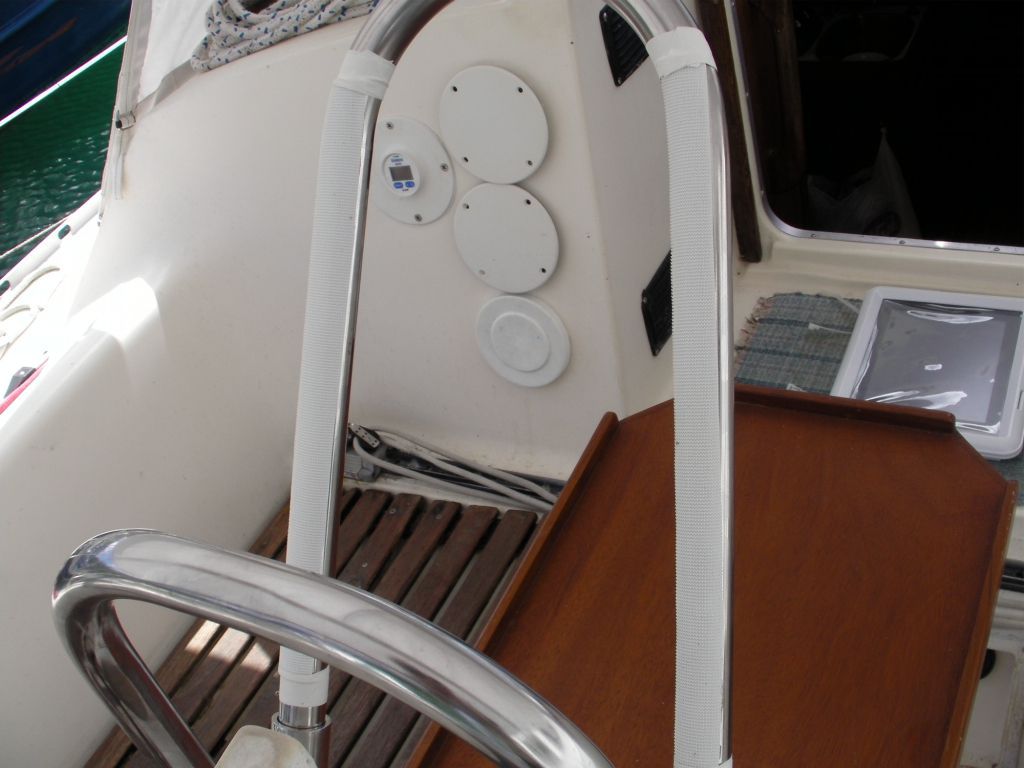
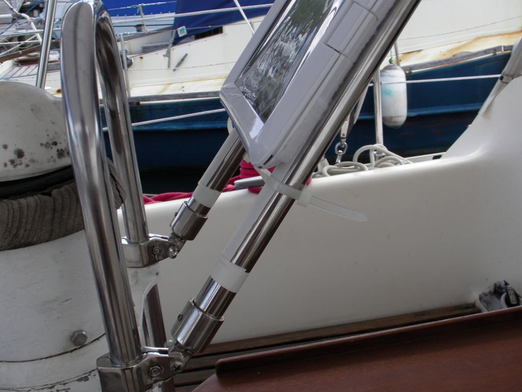
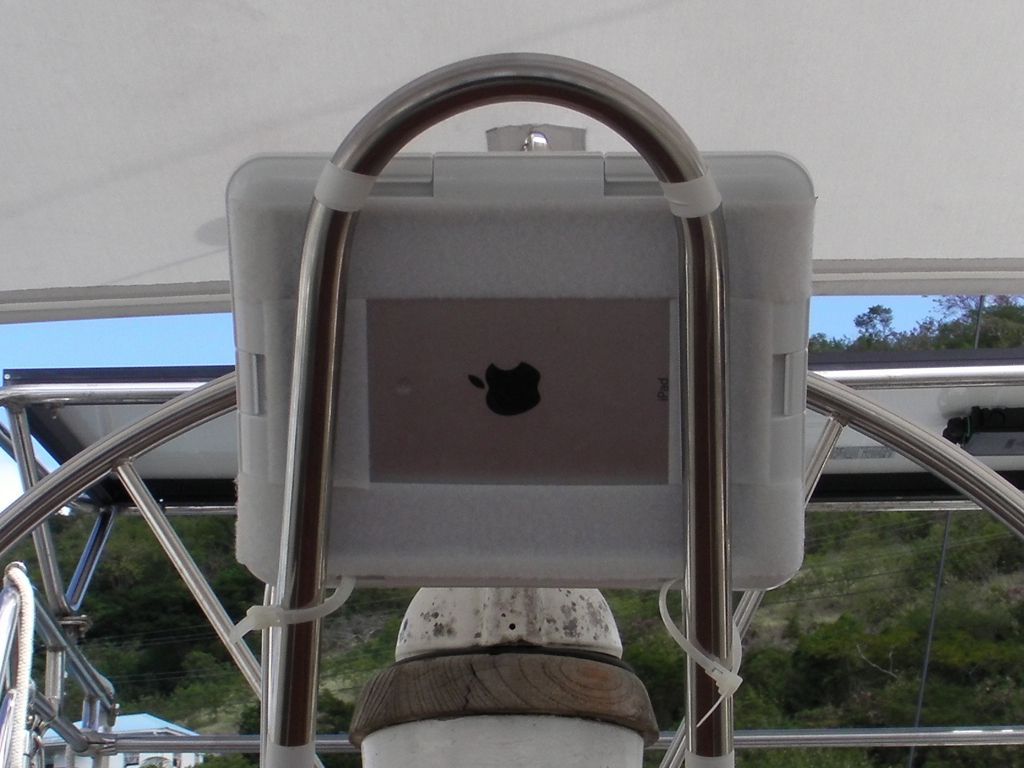
Simple and original mount for iPad
Serge Rousseau, A Canadian navigator, sent me some pictures of the installation of his iPad on his sailboat. He wrote me :
"I'm sending you some photos of the support. I fixed an industrial Velcro on the stainless steel tube and I maintain waterproof case (+or- 50 €) with reusable fasteners (Tie Wrap). You can also use a waterproof envelope used to protect the maps in kayaks and secure it with velcro and reustable ties. ”
For a particularly economical solution, I find it simple, clever and aesthetic enough for my own opinion. It's up to you to judge…


NMEA 2000, a network standard of the future
![]() NMEA 2000® (¹) is a standard for electronic communication network specifically designed for pleasure boats, according to an industry standard published by the National Marine Electronics Association (NMEA). It aims to meet many needs, arising from the considerable increase of electronic devices onboard, the widespread use of computers and MFDs (²) with control and navigation application more sophisticated. It also aims to interconnect equipment provided by various manufacturers and brands, allowing boat builders and users great freedom in the choice of their navigation instruments. Read more …
NMEA 2000® (¹) is a standard for electronic communication network specifically designed for pleasure boats, according to an industry standard published by the National Marine Electronics Association (NMEA). It aims to meet many needs, arising from the considerable increase of electronic devices onboard, the widespread use of computers and MFDs (²) with control and navigation application more sophisticated. It also aims to interconnect equipment provided by various manufacturers and brands, allowing boat builders and users great freedom in the choice of their navigation instruments. Read more …
Miniplex-2Wi, the new WiFi multiplexer for iPad and iPhone
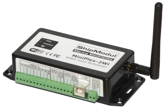 The company ShipModul website has just presented on its website its brand new WiFi multiplexer, Miniplex-2Wi. The Miniples-2Wi only regards boats owners with NMEA 0183 and/or RAYMARINE SeaTalk instruments. For boats with NMEA 2000, network, refer to the excellent SeaSmart WiFi Recently featured on this blog.
Search for charts information data with iNavX
![]() Navionics vector charts contain a number of detailed information for each marina, and sometimes certain anchorages. These places are marked on charts by the symbol shown against.
Navionics vector charts contain a number of detailed information for each marina, and sometimes certain anchorages. These places are marked on charts by the symbol shown against.
This data is called "Navaids" when the information relates to navigation, and "POIs" when dealing with practical and interesting information (Point Of Interest, The "s" is the plural). Read more …
Seasmart WiFi connects NMEA network 2000 to your iPad
 March, the SeaSmart WiFi, presented by iTabNav.fr at the Nautic de Paris last week, allows a WiFi connection to iPad , iPhone or other computer over WiFi to a NMEA network 2000.
Designed by Chetco Digital Instruments, Brookings, Oregon (USA), SeaSmart is a wireless transmitter NMEA2000 and NMEA0183 compatible consists of an USB/serial gateway, a WiFi transmitter 802.11 b/g and an embedded CGI/AJAX web server. Compatible with web browsers on most smartphones, like iPhone, iPad or Android, SeaSmart.Net translates NMEA 2000 (PGNs) messages through an open protocol in HTML pages updated in real time and sent streaming to web server. The transfer is bi-directional. In addition, NMEA 0183 connector allows to interface instruments that use this protocol, like an AIS, their data being multiplexed and added to the flow of data powered by SeaSmart.net. Read more …
iOS 5 can erase your Navionics charts without warning
Good surprise during the ARC transatlantic 2011.
After transferring photos from my device to my iPad, for an unknown reason the storage memory was full. I had 9GB free and I only transferred the contents of a 2GB SD-Card. Mystery !
Anyway, after two or three system messages warning me of the upcoming saturation, iOS 5 has simply deleted all my Navionics map used by iNavX !
When asked by e-mail, Rich Ray confirmed the fact possible :
"This is an unfortunate change in iOS5, the iOS will and can clear any apps downloaded data without notice if another app needs more space.. iOS doesn't give any notification to the app if this happens".
Olivier Bouyssou told me it was possible for developers to store application data in a folder reserved unerasable, but that this was rarely allowed by Apple. This was a big problem because no one knew how iOS selected which apps it cleared from.
Yachtmen my friends, be prudent : if you do not want to lose your charting during the cruise, away from any network allowing you to download them again, monitor the available space of your iPad and iPhone.
Navigation with iPad trainings : a complete solution
 With Weather4D PRO and Iridium Mail, associated with a satellite phone Iridium, we now have a complete solution, reliable and low cost to receive, display and manage GRIB files in open seas with iPad.
iNavX and Navionics cartography also provide a complete navigation solution, supporting files transfers with Weather4D PRO : GRIB, routes, tracks, that allows simultaneous display in both applications.
These solutions, perfectly complementary and consistent with each other, have been tested on more than 2800 NM in the automn during a crossing from Canaria to the Caribbean, on board Catana 47 "Burst", token place in ARC rally 2011. In addition, Olivier Bouyssou was able to improve his Weather4D Pro application "over time", correcting, adding and optimizing daily development onboard. Read more …
Weather4D PRO 1.0 integrates routes from iNavX
 The new app Weather4D PRO for iOS (iPhone / iPad), developed by Olivier Bouyssou, was submited yesterday to Apple. It provides advanced functions associated with GRIB files for demanding users. It comes in addition to Weather4D app which was promoted as one of the best apps in Apple AppStore for few weeks.
This Pro version, quickly available, will provide following features :
GRIB files management :
- Importation, sharing (export ), copy-paste, folders filing, history, request from SailDocs by email
Routes management :
- Route import in KML format from iNavX or other apps, overlay route display with forecasts, boat progress with forecasts scrolling, route settings (heading, speed, date, etc…).
Iridium satellites tracking :
- Prediction of transition from Iridium satellites to optimize the connections to run queries GRIB files. Automatic updating of ephemeris and parameter setting coverage (rising, timing). Read more …
I am writing to you from Gibraltar
Hey yes ! After this wonderful stay on the island of Reunion, here I am embarked without transition aboard "Rafale", a Catana 47 chartered for the ARC rally, A specially equipped proprietary model with carbon mast, Horn Mylar SGS, spinnaker, and other I forget . Underway to the Canarias, via Gibraltar, to start in Las Palmas.

Under way to Gibraltar